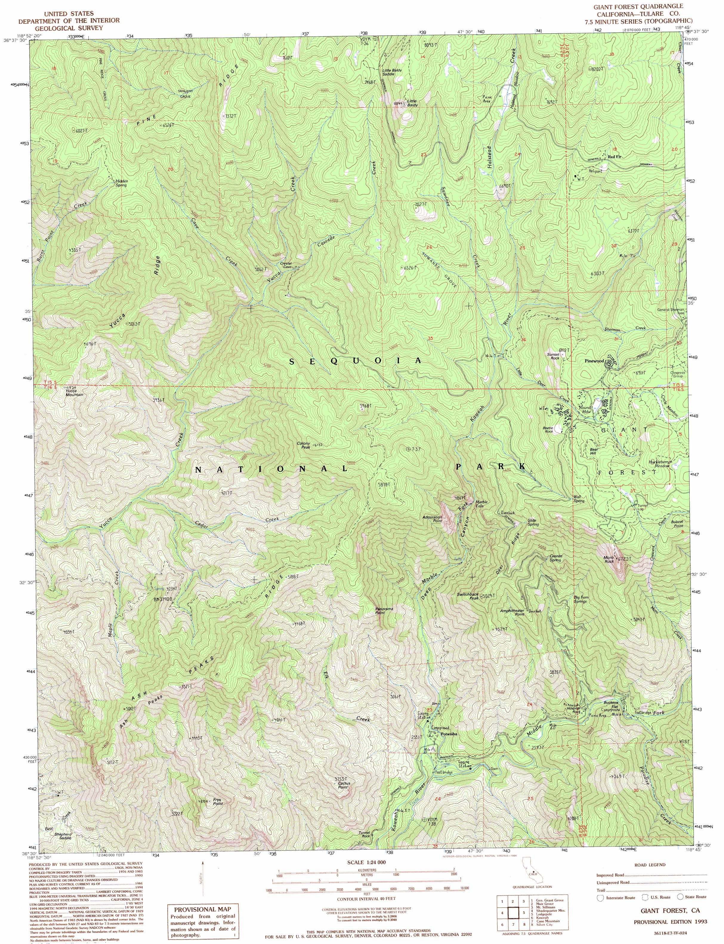
Giant Forest Topo Map California
To zoom in, hover over the map of Giant Forest
USGS Topo Quad 36118e7 - 1:24,000 scale
| Topo Map Name: | Giant Forest |
| USGS Topo Quad ID: | 36118e7 |
| Print Size: | ca. 21 1/4" wide x 27" high |
| Southeast Coordinates: | 36.5° N latitude / 118.75° W longitude |
| Map Center Coordinates: | 36.5625° N latitude / 118.8125° W longitude |
| U.S. State: | CA |
| Filename: | o36118e7.jpg |
| Download Map JPG Image: | Giant Forest topo map 1:24,000 scale |
| Map Type: | Topographic |
| Topo Series: | 7.5´ |
| Map Scale: | 1:24,000 |
| Source of Map Images: | United States Geological Survey (USGS) |
| Alternate Map Versions: |
Giant Forest CA 1987, updated 1987 Download PDF Buy paper map Giant Forest CA 1993, updated 1994 Download PDF Buy paper map Giant Forest CA 2012 Download PDF Buy paper map Giant Forest CA 2015 Download PDF Buy paper map |
1:24,000 Topo Quads surrounding Giant Forest
Verplank Ridge |
Hume |
Wren Peak |
Cedar Grove |
The Sphinx |
Miramonte |
General Grant Grove |
Muir Grove |
Mount Stillman |
Sphinx Lakes |
Auckland |
Shadequarter Mountain |
Giant Forest |
Lodgepole |
Triple Divide Peak |
Woodlake |
Kaweah |
Case Mountain |
Silver City |
Mineral King |
Rocky Hill |
Chickencoop Canyon |
Dennison Peak |
Moses Mountain |
Quinn Peak |
> Back to 36118e1 at 1:100,000 scale
> Back to 36118a1 at 1:250,000 scale
> Back to U.S. Topo Maps home
Giant Forest topo map: Gazetteer
Giant Forest: Capes
Admiration Point elevation 1412m 4632′Amphitheater Point elevation 1339m 4393′
Bobcat Point elevation 1963m 6440′
Panorama Point elevation 1383m 4537′
Giant Forest: Falls
Marble Falls elevation 1338m 4389′Giant Forest: Flats
Buckeye Flat elevation 850m 2788′Circle Meadow elevation 2107m 6912′
Halstead Meadow elevation 2128m 6981′
Huckleberry Meadow elevation 2036m 6679′
Round Meadow elevation 1950m 6397′
Giant Forest: Forests
Giant Forest elevation 2125m 6971′Sequoia National Forest elevation 1956m 6417′
Giant Forest: Gaps
Little Baldy Saddle elevation 2241m 7352′Shepherd Saddle elevation 918m 3011′
Giant Forest: Pillars
Beetle Rock elevation 1952m 6404′Hospital Rock elevation 836m 2742′
Tunnel Rock elevation 607m 1991′
Giant Forest: Populated Places
Pinewood elevation 2013m 6604′Potwisha elevation 657m 2155′
Red Fir elevation 2156m 7073′
Giant Forest: Ridges
Ash Peaks Ridge elevation 1870m 6135′Cactus Point elevation 1133m 3717′
Deer Ridge elevation 1593m 5226′
Peaks Ridge elevation 1581m 5187′
Pine Ridge elevation 2322m 7618′
Yucca Ridge elevation 1526m 5006′
Giant Forest: Springs
Big Fern Springs elevation 1200m 3937′Granite Spring elevation 1467m 4812′
Hidden Spring elevation 1679m 5508′
Slide Spring elevation 1675m 5495′
Wall Spring elevation 1866m 6122′
Giant Forest: Streams
Cascade Creek elevation 2165m 7103′Cave Creek elevation 1220m 4002′
Cedar Creek elevation 812m 2664′
Crescent Creek elevation 1288m 4225′
Elk Creek elevation 616m 2020′
Halstead Creek elevation 1591m 5219′
Little Deer Creek elevation 1587m 5206′
Maple Creek elevation 746m 2447′
Marble Fork Kaweah River elevation 618m 2027′
Middle Fork Kaweah River elevation 618m 2027′
Paradise Creek elevation 863m 2831′
Sherman Creek elevation 1687m 5534′
Suwanee Creek elevation 1583m 5193′
Wolverton Creek elevation 1908m 6259′
Giant Forest: Summits
Ash Peaks elevation 1709m 5606′Bear Hill elevation 2045m 6709′
Colony Peak elevation 1870m 6135′
Frys Point elevation 1382m 4534′
Little Baldy elevation 2453m 8047′
Moro Rock elevation 1985m 6512′
Sunset Rock elevation 1941m 6368′
Switchback Peak elevation 1514m 4967′
Yucca Mountain elevation 1497m 4911′
Giant Forest: Valleys
Deep Canyon elevation 683m 2240′Giant Forest: Woods
Skagway Grove elevation 1816m 5958′Suwanee Grove elevation 1878m 6161′
Giant Forest digital topo map on disk
Buy this Giant Forest topo map showing relief, roads, GPS coordinates and other geographical features, as a high-resolution digital map file on DVD:
Southern Sierra Nevada, California & Southern Nevada
Buy digital topo maps: Southern Sierra Nevada, California & Southern Nevada