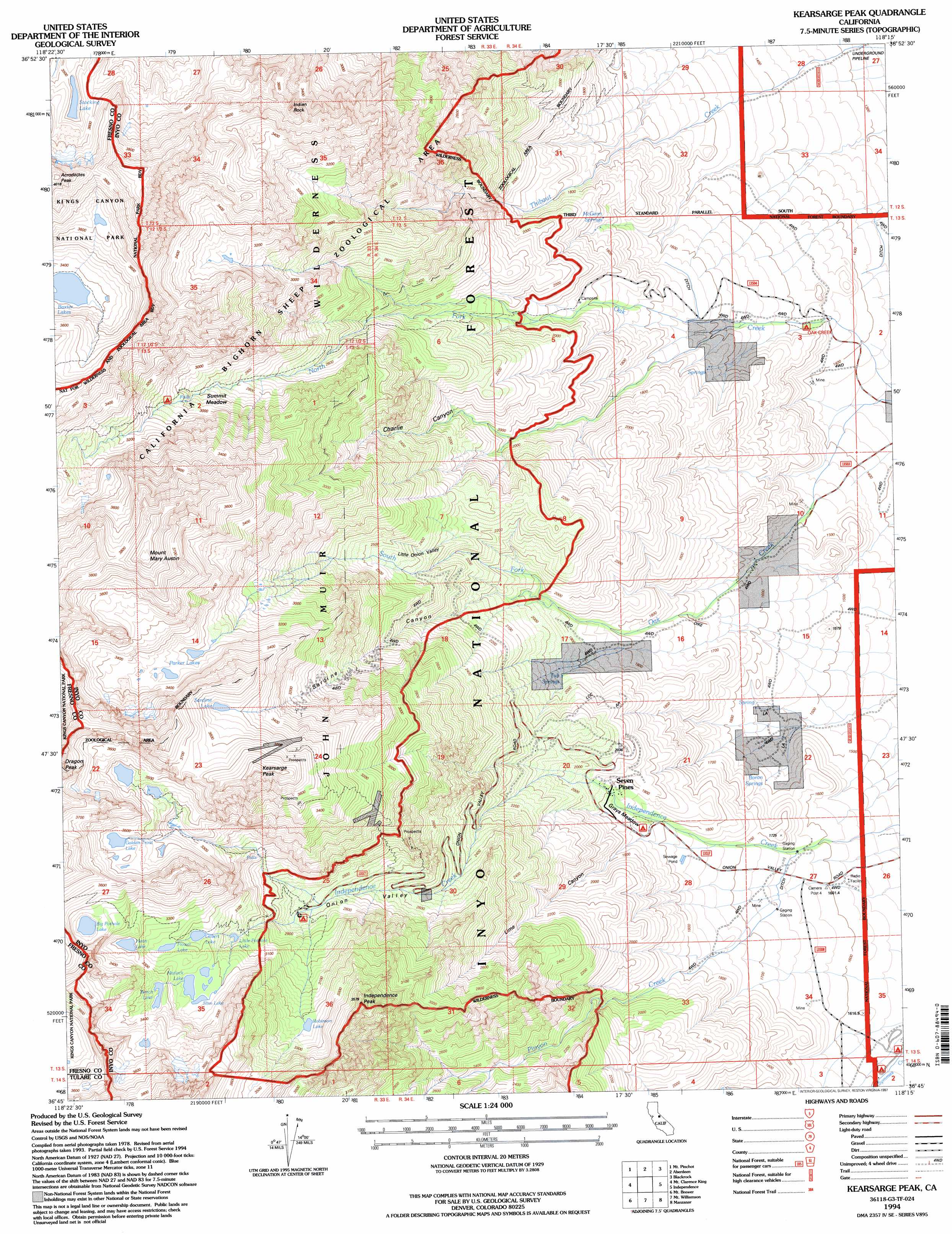
Kearsarge Peak Topo Map California
To zoom in, hover over the map of Kearsarge Peak
USGS Topo Quad 36118g3 - 1:24,000 scale
| Topo Map Name: | Kearsarge Peak |
| USGS Topo Quad ID: | 36118g3 |
| Print Size: | ca. 21 1/4" wide x 27" high |
| Southeast Coordinates: | 36.75° N latitude / 118.25° W longitude |
| Map Center Coordinates: | 36.8125° N latitude / 118.3125° W longitude |
| U.S. State: | CA |
| Filename: | o36118g3.jpg |
| Download Map JPG Image: | Kearsarge Peak topo map 1:24,000 scale |
| Map Type: | Topographic |
| Topo Series: | 7.5´ |
| Map Scale: | 1:24,000 |
| Source of Map Images: | United States Geological Survey (USGS) |
| Alternate Map Versions: |
Kearsarge Peak CA 1985, updated 1985 Download PDF Buy paper map Kearsarge Peak CA 1992, updated 1994 Download PDF Buy paper map Kearsarge Peak CA 1994, updated 1997 Download PDF Buy paper map Kearsarge Peak CA 2012 Download PDF Buy paper map Kearsarge Peak CA 2015 Download PDF Buy paper map |
| FStopo: | US Forest Service topo Kearsarge Peak is available: Download FStopo PDF Download FStopo TIF |
1:24,000 Topo Quads surrounding Kearsarge Peak
North Palisade |
Split Mountain |
Fish Springs |
Tinemaha Reservoir |
Waucoba Mountain |
Marion Peak |
Mount Pinchot |
Aberdeen |
Blackrock |
Mazourka Peak |
The Sphinx |
Mount Clarence King |
Kearsarge Peak |
Independence |
Bee Springs Canyon |
Sphinx Lakes |
Mount Brewer |
Mount Williamson |
Manzanar |
Union Wash |
Triple Divide Peak |
Mount Kaweah |
Mount Whitney |
Mount Langley |
Lone Pine |
> Back to 36118e1 at 1:100,000 scale
> Back to 36118a1 at 1:250,000 scale
> Back to U.S. Topo Maps home
Kearsarge Peak topo map: Gazetteer
Kearsarge Peak: Basins
Little Onion elevation 2373m 7785′Onion Valley elevation 2700m 8858′
Kearsarge Peak: Flats
Grays Meadow elevation 1817m 5961′Lower Grays Meadow elevation 1744m 5721′
Summit Meadow elevation 3086m 10124′
Kearsarge Peak: Lakes
Bench Lake elevation 3318m 10885′Big Pothole Lake elevation 3436m 11272′
Flower Lake elevation 3215m 10547′
Gilbert Lake elevation 3177m 10423′
Golden Trout Lake elevation 3475m 11400′
Heart Lake elevation 3298m 10820′
Little Pothole Lake elevation 3070m 10072′
Matlock Lake elevation 3216m 10551′
Parker Lakes elevation 3347m 10980′
Robinson Lake elevation 3217m 10554′
Sardine Lake elevation 3535m 11597′
Slim Lake elevation 3218m 10557′
Stocking Lake elevation 3525m 11564′
Kearsarge Peak: Mines
Big Ram Mine elevation 2268m 7440′Declaration Mine elevation 1471m 4826′
Grand Group elevation 3531m 11584′
Kearsarge Group elevation 2765m 9071′
Phoenix Group elevation 2735m 8973′
Rex Montis Mine elevation 3710m 12171′
Virginia Group elevation 2915m 9563′
Kearsarge Peak: Parks
California Bighorn Sheep Zoological Area elevation 3067m 10062′Kearsarge Peak: Populated Places
Seven Pines elevation 1889m 6197′Kearsarge Peak: Springs
Boron Springs elevation 1590m 5216′McGann Springs elevation 1760m 5774′
Tub Springs elevation 1936m 6351′
Kearsarge Peak: Streams
North Fork Oak Creek elevation 1335m 4379′Pinyon Creek elevation 1636m 5367′
South Fork Oak Creek elevation 1337m 4386′
Kearsarge Peak: Summits
Independence Peak elevation 3536m 11601′Indian Rock elevation 3709m 12168′
Kearsarge Peak elevation 3847m 12621′
Mount Baxter elevation 3947m 12949′
Mount Mary Austin elevation 3958m 12985′
Kearsarge Peak: Valleys
Black Canyon elevation 1749m 5738′Charlie Canyon elevation 1969m 6459′
Lime Canyon elevation 1760m 5774′
Sardine Canyon elevation 1942m 6371′
Kearsarge Peak digital topo map on disk
Buy this Kearsarge Peak topo map showing relief, roads, GPS coordinates and other geographical features, as a high-resolution digital map file on DVD:
Southern Sierra Nevada, California & Southern Nevada
Buy digital topo maps: Southern Sierra Nevada, California & Southern Nevada