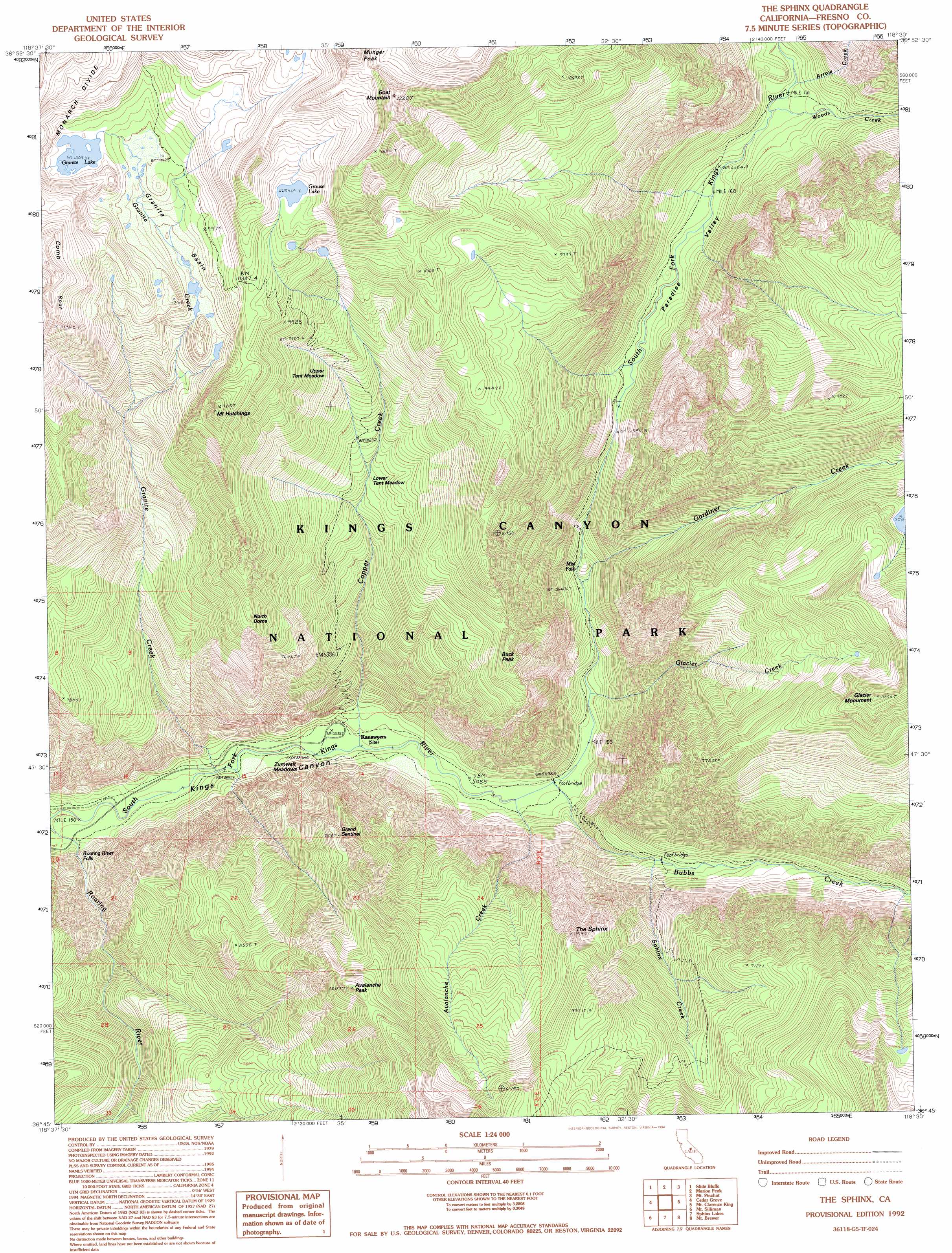
The Sphinx Topo Map California
To zoom in, hover over the map of The Sphinx
USGS Topo Quad 36118g5 - 1:24,000 scale
| Topo Map Name: | The Sphinx |
| USGS Topo Quad ID: | 36118g5 |
| Print Size: | ca. 21 1/4" wide x 27" high |
| Southeast Coordinates: | 36.75° N latitude / 118.5° W longitude |
| Map Center Coordinates: | 36.8125° N latitude / 118.5625° W longitude |
| U.S. State: | CA |
| Filename: | o36118g5.jpg |
| Download Map JPG Image: | The Sphinx topo map 1:24,000 scale |
| Map Type: | Topographic |
| Topo Series: | 7.5´ |
| Map Scale: | 1:24,000 |
| Source of Map Images: | United States Geological Survey (USGS) |
| Alternate Map Versions: |
The Sphinx CA 1988, updated 1988 Download PDF Buy paper map The Sphinx CA 1992, updated 1994 Download PDF Buy paper map The Sphinx CA 2012 Download PDF Buy paper map The Sphinx CA 2015 Download PDF Buy paper map |
1:24,000 Topo Quads surrounding The Sphinx
Blackcap Mountain |
Mount Goddard |
North Palisade |
Split Mountain |
Fish Springs |
Tehipite Dome |
Slide Bluffs |
Marion Peak |
Mount Pinchot |
Aberdeen |
Wren Peak |
Cedar Grove |
The Sphinx |
Mount Clarence King |
Kearsarge Peak |
Muir Grove |
Mount Stillman |
Sphinx Lakes |
Mount Brewer |
Mount Williamson |
Giant Forest |
Lodgepole |
Triple Divide Peak |
Mount Kaweah |
Mount Whitney |
> Back to 36118e1 at 1:100,000 scale
> Back to 36118a1 at 1:250,000 scale
> Back to U.S. Topo Maps home
The Sphinx topo map: Gazetteer
The Sphinx: Basins
Granite Basin elevation 2986m 9796′The Sphinx: Falls
Mist Falls elevation 1755m 5757′Roaring River Falls elevation 1550m 5085′
The Sphinx: Flats
Lower Tent Meadow elevation 2271m 7450′Paradise Valley elevation 2021m 6630′
Upper Tent Meadow elevation 2496m 8188′
Zumwalt Meadows elevation 1524m 5000′
The Sphinx: Lakes
Granite Lake elevation 3078m 10098′Grouse Lake elevation 3192m 10472′
The Sphinx: Pillars
Grand Sentinel elevation 2584m 8477′North Dome elevation 2571m 8435′
The Sphinx elevation 2740m 8989′
The Sphinx: Populated Places
Kanawyers elevation 1530m 5019′The Sphinx: Streams
Arrow Creek elevation 2109m 6919′Avalanche Creek elevation 1553m 5095′
Bubbs Creek elevation 1562m 5124′
Copper Creek elevation 1537m 5042′
Gardiner Creek elevation 1719m 5639′
Glacier Creek elevation 1587m 5206′
Granite Creek elevation 1513m 4963′
Sphinx Creek elevation 1888m 6194′
Sugarloaf Creek elevation 1945m 6381′
Woods Creek elevation 2104m 6902′
The Sphinx: Summits
Avalanche Peak elevation 3057m 10029′Buck Peak elevation 2679m 8789′
Glacier Monument elevation 3371m 11059′
Goat Mountain elevation 3686m 12093′
Mount Hutchings elevation 3285m 10777′
Munger Peak elevation 3648m 11968′
The Sphinx: Valleys
Avalanche Canyon elevation 1561m 5121′The Sphinx digital topo map on disk
Buy this The Sphinx topo map showing relief, roads, GPS coordinates and other geographical features, as a high-resolution digital map file on DVD:
Southern Sierra Nevada, California & Southern Nevada
Buy digital topo maps: Southern Sierra Nevada, California & Southern Nevada