Mazourka Peak Topo Map California
To zoom in, hover over the map of Mazourka Peak
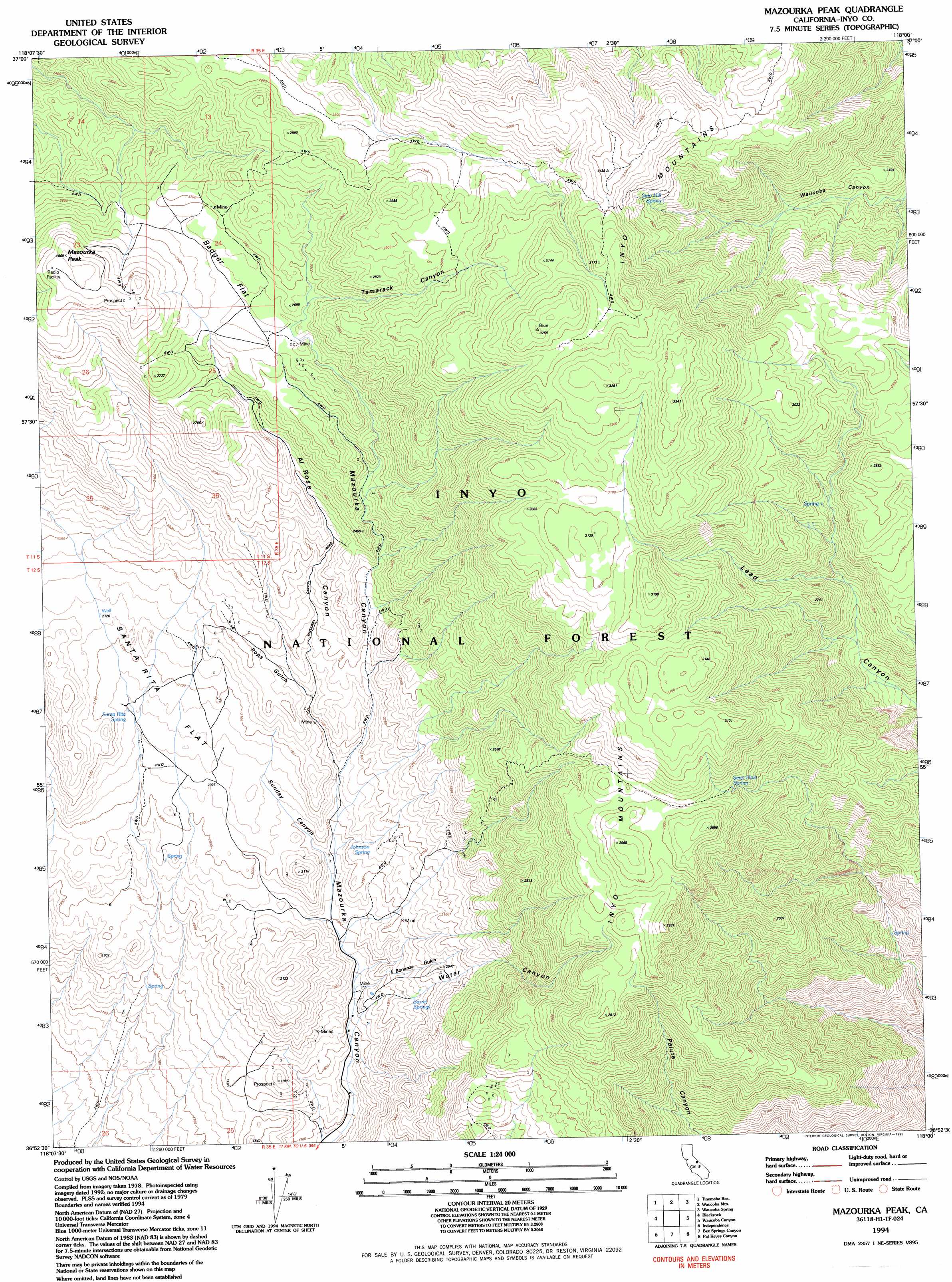
USGS Topo Quad 36118h1 - 1:24,000 scale
| Topo Map Name: | Mazourka Peak |
| USGS Topo Quad ID: | 36118h1 |
| Print Size: | ca. 21 1/4" wide x 27" high |
| Southeast Coordinates: | 36.875° N latitude / 118° W longitude |
| Map Center Coordinates: | 36.9375° N latitude / 118.0625° W longitude |
| U.S. State: | CA |
| Filename: | o36118h1.jpg |
| Download Map JPG Image: | Mazourka Peak topo map 1:24,000 scale |
| Map Type: | Topographic |
| Topo Series: | 7.5´ |
| Map Scale: | 1:24,000 |
| Source of Map Images: | United States Geological Survey (USGS) |
| Alternate Map Versions: |
Mazourka Peak CA 1979, updated 1994 Download PDF Buy paper map Mazourka Peak CA 1982, updated 1983 Download PDF Buy paper map Mazourka Peak CA 1982, updated 1987 Download PDF Buy paper map Mazourka Peak CA 1994, updated 1995 Download PDF Buy paper map Mazourka Peak CA 1994, updated 1997 Download PDF Buy paper map Mazourka Peak CA 2012 Download PDF Buy paper map Mazourka Peak CA 2015 Download PDF Buy paper map |
| FStopo: | US Forest Service topo Mazourka Peak is available: Download FStopo PDF Download FStopo TIF |
1:24,000 Topo Quads surrounding Mazourka Peak
Big Pine |
Uhlmeyer Spring |
Cowhorn Valley |
Joshua Flats |
East Of Joshua Flats |
Fish Springs |
Tinemaha Reservoir |
Waucoba Mountain |
Waucoba Spring |
East Of Waucoba Spring |
Aberdeen |
Blackrock |
Mazourka Peak |
Waucoba Canyon |
East Of Waucoba Canyon |
Kearsarge Peak |
Independence |
Bee Springs Canyon |
Pat Keyes Canyon |
Lower Warm Springs |
Mount Williamson |
Manzanar |
Union Wash |
New York Butte |
Craig Canyon |
> Back to 36118e1 at 1:100,000 scale
> Back to 36118a1 at 1:250,000 scale
> Back to U.S. Topo Maps home
Mazourka Peak topo map: Gazetteer
Mazourka Peak: Flats
Badger Flat elevation 2644m 8674′Santa Rita Flat elevation 2052m 6732′
Mazourka Peak: Mines
Abestos Number 1 Prospect elevation 2033m 6669′Badger Flat Prospects elevation 2631m 8631′
Barrel Springs Group Placer Mine elevation 1847m 6059′
Black Lady Mine elevation 2001m 6564′
Blackbird Prospect elevation 2078m 6817′
Blue Bell Mine elevation 2728m 8950′
Blue Stone Talc Mine elevation 2282m 7486′
Copper Empire Group Mine elevation 1862m 6108′
D R Mar Jak Mine elevation 2096m 6876′
Gold Rabbit Prospect elevation 1725m 5659′
Good Luck Prospect elevation 2614m 8576′
Gray Eagle Talc Mine elevation 2083m 6833′
Hidden Valley Numbers 1-6 Prospects elevation 2360m 7742′
Joe Diaz Prospect elevation 2325m 7627′
Julia R Numbers 1-3 Prospects elevation 1926m 6318′
Lucilles Lucky Star Prospect elevation 2176m 7139′
Maid of Erin Mine elevation 1901m 6236′
Mexican Hat Prospect elevation 2826m 9271′
Michaels 322 Prospect elevation 2684m 8805′
Philday Lode Prospect elevation 1725m 5659′
Platta Blanca Mine elevation 2481m 8139′
Saint Phillip Prospect elevation 2667m 8750′
Santa Rita Numbers 1-9 Placer Mines elevation 2036m 6679′
Seventy-Niner Numbers 1-2 Prospects elevation 1601m 5252′
Susan Number 1 Prospect elevation 2342m 7683′
Talco Prospect elevation 2459m 8067′
Western Minnesota Mining Association Placer Mine elevation 2124m 6968′
Zincite Prospect elevation 2630m 8628′
Mazourka Peak: Springs
Barrel Springs elevation 1941m 6368′Johnson Spring elevation 2031m 6663′
Santa Rita Spring elevation 2067m 6781′
Seep Hole Spring elevation 2797m 9176′
Side Hill Spring elevation 2852m 9356′
Mazourka Peak: Summits
Mazourka Peak elevation 2863m 9393′Mazourka Peak: Valleys
Al Rose Canyon elevation 2052m 6732′Bonanza Gulch elevation 1841m 6040′
Pops Gulch elevation 2117m 6945′
Sunday Canyon elevation 1952m 6404′
Tamarack Canyon elevation 2669m 8756′
Water Canyon elevation 1841m 6040′
Mazourka Peak digital topo map on disk
Buy this Mazourka Peak topo map showing relief, roads, GPS coordinates and other geographical features, as a high-resolution digital map file on DVD:
Southern Sierra Nevada, California & Southern Nevada
Buy digital topo maps: Southern Sierra Nevada, California & Southern Nevada