Exeter Topo Map California
To zoom in, hover over the map of Exeter
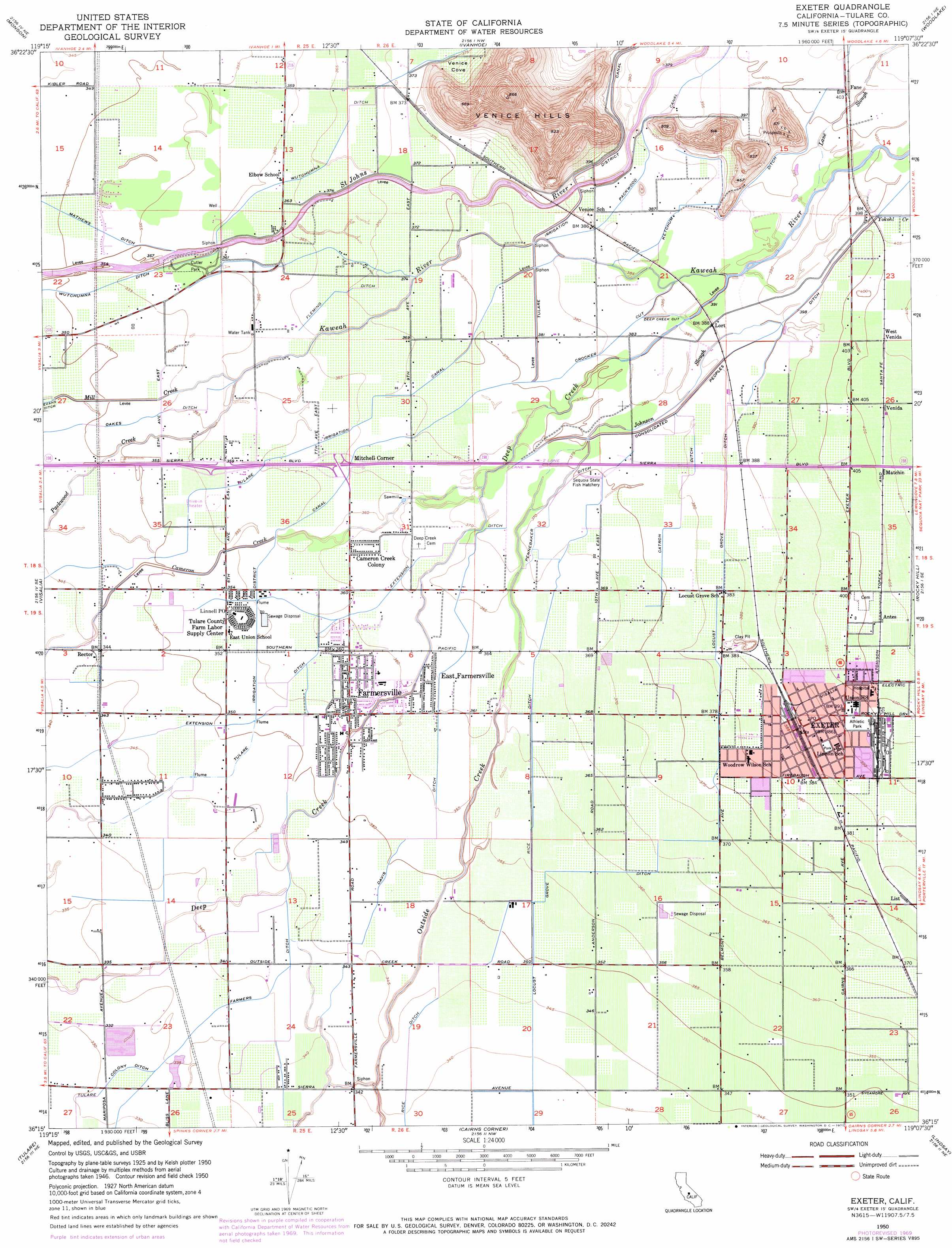
USGS Topo Quad 36119c2 - 1:24,000 scale
| Topo Map Name: | Exeter |
| USGS Topo Quad ID: | 36119c2 |
| Print Size: | ca. 21 1/4" wide x 27" high |
| Southeast Coordinates: | 36.25° N latitude / 119.125° W longitude |
| Map Center Coordinates: | 36.3125° N latitude / 119.1875° W longitude |
| U.S. State: | CA |
| Filename: | o36119c2.jpg |
| Download Map JPG Image: | Exeter topo map 1:24,000 scale |
| Map Type: | Topographic |
| Topo Series: | 7.5´ |
| Map Scale: | 1:24,000 |
| Source of Map Images: | United States Geological Survey (USGS) |
| Alternate Map Versions: |
Exeter CA 1950, updated 1952 Download PDF Buy paper map Exeter CA 1950, updated 1971 Download PDF Buy paper map Exeter CA 1950, updated 1971 Download PDF Buy paper map Exeter CA 2012 Download PDF Buy paper map Exeter CA 2015 Download PDF Buy paper map |
1:24,000 Topo Quads surrounding Exeter
Reedley |
Orange Cove South |
Stokes Mountain |
Auckland |
Shadequarter Mountain |
Traver |
Monson |
Ivanhoe |
Woodlake |
Kaweah |
Goshen |
Visalia |
Exeter |
Rocky Hill |
Chickencoop Canyon |
Paige |
Tulare |
Cairns Corner |
Lindsay |
Frazier Valley |
Taylor Weir |
Tipton |
Woodville |
Porterville |
Success Dam |
> Back to 36119a1 at 1:100,000 scale
> Back to 36118a1 at 1:250,000 scale
> Back to U.S. Topo Maps home
Exeter topo map: Gazetteer
Exeter: Canals
Catron Ditch elevation 117m 383′Consolidated Peoples Ditch elevation 119m 390′
Crocker Cut elevation 117m 383′
Davis Ditch elevation 108m 354′
Deep Creek Cut elevation 118m 387′
Extension Ditch elevation 109m 357′
Fleming Ditch elevation 114m 374′
Ketchum Ditch elevation 121m 396′
Locust Grove Ditch elevation 109m 357′
Packwood Canal elevation 120m 393′
Pennebaker Ditch elevation 115m 377′
Rice Ditch elevation 105m 344′
Exeter: Guts
Johnson Slough elevation 117m 383′Exeter: Parks
Ash Street Park elevation 110m 360′Cutler Park elevation 110m 360′
Exeter City Athletic Park elevation 120m 393′
Jennings Park elevation 110m 360′
Roys Park elevation 108m 354′
Exeter: Populated Places
Antes elevation 123m 403′Cameron Creek Colony elevation 111m 364′
East Farmersville elevation 110m 360′
Exeter elevation 119m 390′
Fane elevation 124m 406′
Farmersville elevation 109m 357′
Giant Oak (historical) elevation 111m 364′
List elevation 116m 380′
Lort elevation 120m 393′
Matchin elevation 125m 410′
Mitchell Corner elevation 112m 367′
Musk (historical) elevation 119m 390′
Rector elevation 106m 347′
Venida elevation 126m 413′
West Venida elevation 126m 413′
Exeter: Post Offices
Exeter Post Office elevation 119m 390′Farmersville Post Office elevation 110m 360′
Linnell Post Office elevation 109m 357′
Exeter: Ranges
Venice Hills elevation 184m 603′Exeter: Streams
Kaweah River elevation 108m 354′Lane Slough elevation 120m 393′
Yokohl Creek elevation 118m 387′
Exeter: Valleys
Venice Cove elevation 115m 377′Exeter digital topo map on disk
Buy this Exeter topo map showing relief, roads, GPS coordinates and other geographical features, as a high-resolution digital map file on DVD:
Southern Sierra Nevada, California & Southern Nevada
Buy digital topo maps: Southern Sierra Nevada, California & Southern Nevada