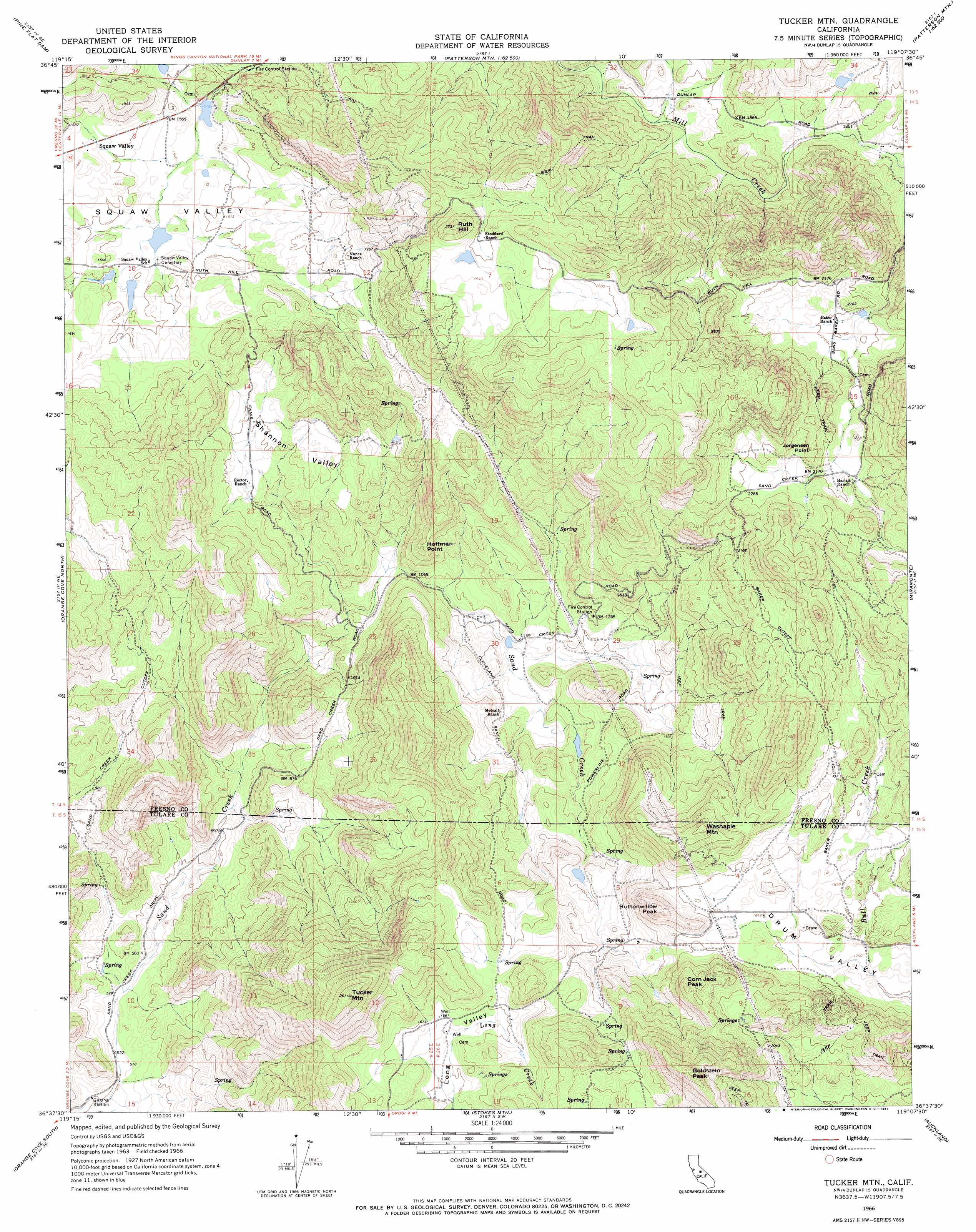
Tucker Mountain Topo Map California
To zoom in, hover over the map of Tucker Mountain
USGS Topo Quad 36119f2 - 1:24,000 scale
| Topo Map Name: | Tucker Mountain |
| USGS Topo Quad ID: | 36119f2 |
| Print Size: | ca. 21 1/4" wide x 27" high |
| Southeast Coordinates: | 36.625° N latitude / 119.125° W longitude |
| Map Center Coordinates: | 36.6875° N latitude / 119.1875° W longitude |
| U.S. State: | CA |
| Filename: | o36119f2.jpg |
| Download Map JPG Image: | Tucker Mountain topo map 1:24,000 scale |
| Map Type: | Topographic |
| Topo Series: | 7.5´ |
| Map Scale: | 1:24,000 |
| Source of Map Images: | United States Geological Survey (USGS) |
| Alternate Map Versions: |
Tucker Mtn CA 1966, updated 1967 Download PDF Buy paper map Tucker Mtn CA 1966, updated 1967 Download PDF Buy paper map Tucker Mountain CA 2012 Download PDF Buy paper map Tucker Mountain CA 2015 Download PDF Buy paper map |
1:24,000 Topo Quads surrounding Tucker Mountain
Humphreys Station |
Trimmer |
Sacate Ridge |
Patterson Mountain |
Rough Spur |
Piedra |
Pine Flat Dam |
Luckett Mountain |
Verplank Ridge |
Hume |
Wahtoke |
Orange Cove North |
Tucker Mountain |
Miramonte |
General Grant Grove |
Reedley |
Orange Cove South |
Stokes Mountain |
Auckland |
Shadequarter Mountain |
Traver |
Monson |
Ivanhoe |
Woodlake |
Kaweah |
> Back to 36119e1 at 1:100,000 scale
> Back to 36118a1 at 1:250,000 scale
> Back to U.S. Topo Maps home
Tucker Mountain topo map: Gazetteer
Tucker Mountain: Airports
Baker and Hall Airport elevation 640m 2099′Tucker Mountain: Basins
Drum Valley elevation 524m 1719′Shannon Valley elevation 416m 1364′
Shipes Valley elevation 648m 2125′
Tucker Mountain: Dams
Sand Creek 1691 Dam elevation 194m 636′Tucker Mountain: Populated Places
Hoffman Point elevation 450m 1476′Squaw Valley elevation 497m 1630′
Tucker Mountain: Reservoirs
Sand Creek Reservoir elevation 194m 636′Tucker Mountain: Streams
Little White Deer Creek elevation 514m 1686′Tucker Mountain: Summits
Baker Mountain elevation 864m 2834′Buttonwillow Peak elevation 690m 2263′
Corn Jack Peak elevation 704m 2309′
Goldstein Peak elevation 857m 2811′
Jorgensen Point elevation 733m 2404′
Ruth Hill elevation 782m 2565′
Tucker Mountain elevation 790m 2591′
Washapie Mountain elevation 739m 2424′
Tucker Mountain: Valleys
Little White Deer Valley elevation 528m 1732′Tucker Mountain digital topo map on disk
Buy this Tucker Mountain topo map showing relief, roads, GPS coordinates and other geographical features, as a high-resolution digital map file on DVD:
Southern Sierra Nevada, California & Southern Nevada
Buy digital topo maps: Southern Sierra Nevada, California & Southern Nevada