Verplank Ridge Topo Map California
To zoom in, hover over the map of Verplank Ridge
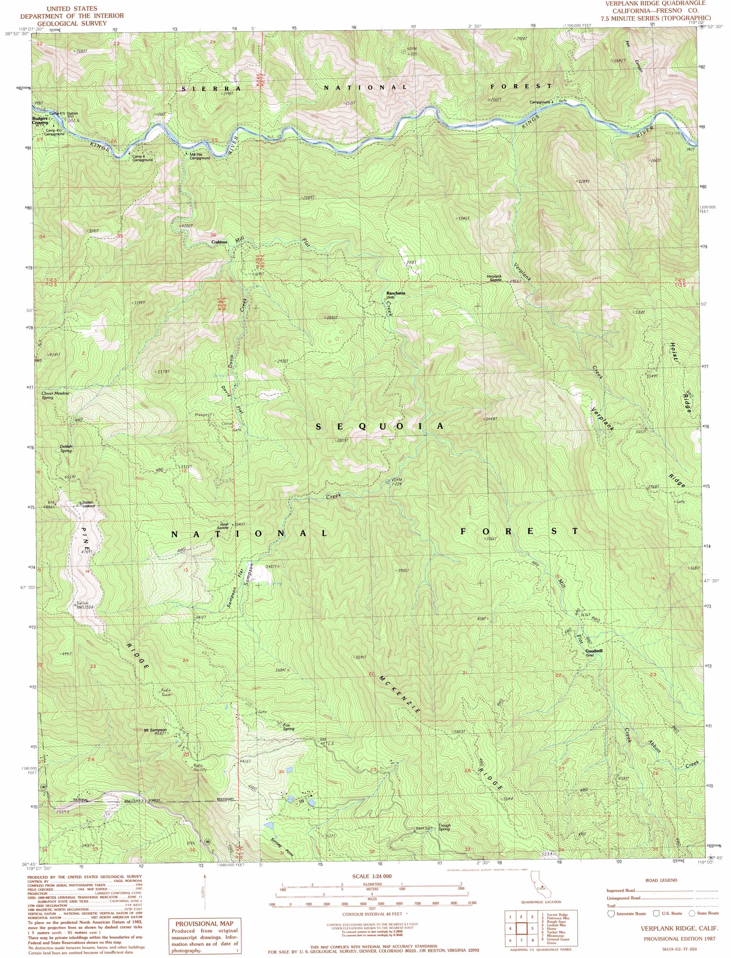
USGS Topo Quad 36119g1 - 1:24,000 scale
| Topo Map Name: | Verplank Ridge |
| USGS Topo Quad ID: | 36119g1 |
| Print Size: | ca. 21 1/4" wide x 27" high |
| Southeast Coordinates: | 36.75° N latitude / 119° W longitude |
| Map Center Coordinates: | 36.8125° N latitude / 119.0625° W longitude |
| U.S. State: | CA |
| Filename: | o36119g1.jpg |
| Download Map JPG Image: | Verplank Ridge topo map 1:24,000 scale |
| Map Type: | Topographic |
| Topo Series: | 7.5´ |
| Map Scale: | 1:24,000 |
| Source of Map Images: | United States Geological Survey (USGS) |
| Alternate Map Versions: |
Verplank Ridge CA 1987, updated 1987 Download PDF Buy paper map Verplank Ridge CA 2012 Download PDF Buy paper map Verplank Ridge CA 2015 Download PDF Buy paper map |
| FStopo: | US Forest Service topo Verplank Ridge is available: Download FStopo PDF Download FStopo TIF |
1:24,000 Topo Quads surrounding Verplank Ridge
Shaver Lake |
Dinkey Creek |
Nelson Mountain |
Courtright Reservoir |
Blackcap Mountain |
Trimmer |
Sacate Ridge |
Patterson Mountain |
Rough Spur |
Tehipite Dome |
Pine Flat Dam |
Luckett Mountain |
Verplank Ridge |
Hume |
Wren Peak |
Orange Cove North |
Tucker Mountain |
Miramonte |
General Grant Grove |
Muir Grove |
Orange Cove South |
Stokes Mountain |
Auckland |
Shadequarter Mountain |
Giant Forest |
> Back to 36119e1 at 1:100,000 scale
> Back to 36118a1 at 1:250,000 scale
> Back to U.S. Topo Maps home
Verplank Ridge topo map: Gazetteer
Verplank Ridge: Crossings
Rogers Crossing elevation 313m 1026′Verplank Ridge: Flats
Davis Flat elevation 659m 2162′Mill Flat elevation 346m 1135′
Sampson Flat elevation 926m 3038′
Verplank Ridge: Gaps
Goat Saddle elevation 1082m 3549′Verplank Saddle elevation 886m 2906′
Verplank Ridge: Populated Places
Crabtree elevation 414m 1358′Goodmill elevation 1133m 3717′
Rodgers Crossing elevation 311m 1020′
Verplank Ridge: Ridges
McKenzie Ridge elevation 1719m 5639′Pine Ridge elevation 1613m 5291′
Verplank Ridge elevation 1633m 5357′
Verplank Ridge: Springs
Clover Meadow Spring elevation 1071m 3513′Delilah Spring elevation 1324m 4343′
Fox Spring elevation 1286m 4219′
Trough Spring elevation 1469m 4819′
Verplank Ridge: Streams
Abbott Creek elevation 1250m 4101′Converse Creek elevation 431m 1414′
Davis Creek elevation 448m 1469′
Mill Flat Creek elevation 356m 1167′
Sampson Creek elevation 667m 2188′
Verplank Creek elevation 379m 1243′
Verplank Ridge: Summits
Mount Sampson elevation 1447m 4747′Sontag Point elevation 1296m 4251′
Verplank Ridge: Valleys
Fox Canyon elevation 412m 1351′Verplank Ridge digital topo map on disk
Buy this Verplank Ridge topo map showing relief, roads, GPS coordinates and other geographical features, as a high-resolution digital map file on DVD:
Southern Sierra Nevada, California & Southern Nevada
Buy digital topo maps: Southern Sierra Nevada, California & Southern Nevada