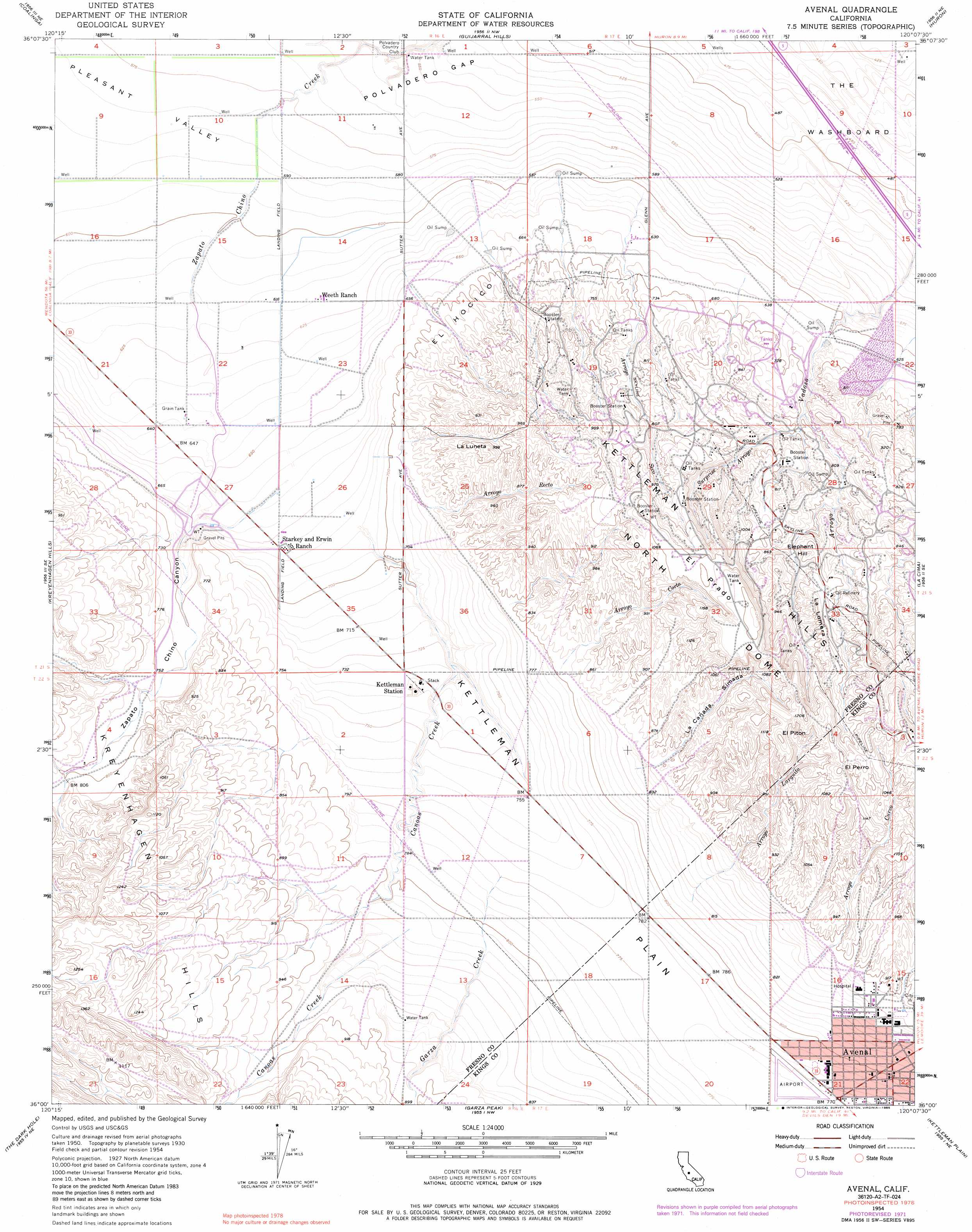
Avenal Topo Map California
To zoom in, hover over the map of Avenal
USGS Topo Quad 36120a2 - 1:24,000 scale
| Topo Map Name: | Avenal |
| USGS Topo Quad ID: | 36120a2 |
| Print Size: | ca. 21 1/4" wide x 27" high |
| Southeast Coordinates: | 36° N latitude / 120.125° W longitude |
| Map Center Coordinates: | 36.0625° N latitude / 120.1875° W longitude |
| U.S. State: | CA |
| Filename: | o36120a2.jpg |
| Download Map JPG Image: | Avenal topo map 1:24,000 scale |
| Map Type: | Topographic |
| Topo Series: | 7.5´ |
| Map Scale: | 1:24,000 |
| Source of Map Images: | United States Geological Survey (USGS) |
| Alternate Map Versions: |
Canoas Creek CA 1950 Download PDF Buy paper map Avenal CA 1954, updated 1957 Download PDF Buy paper map Avenal CA 1954, updated 1967 Download PDF Buy paper map Avenal CA 1954, updated 1967 Download PDF Buy paper map Avenal CA 1954, updated 1972 Download PDF Buy paper map Avenal CA 1954, updated 1972 Download PDF Buy paper map Avenal CA 1954, updated 1985 Download PDF Buy paper map Avenal CA 2012 Download PDF Buy paper map Avenal CA 2015 Download PDF Buy paper map |
1:24,000 Topo Quads surrounding Avenal
Joaquin Rocks |
Domengine Ranch |
Harris Ranch |
Calflax |
Vanguard |
Alcalde Hills |
Coalinga |
Guijarral Hills |
Huron |
Westhaven |
Curry Mountain |
Kreyenhagen Hills |
Avenal |
La Cima |
Kettleman City |
Parkfield |
The Dark Hole |
Garza Peak |
Kettleman Plain |
Los Viejos |
Cholame Hills |
Cholame Valley |
Tent Hills |
Pyramid Hills |
Avenal Gap |
> Back to 36120a1 at 1:100,000 scale
> Back to 36120a1 at 1:250,000 scale
> Back to U.S. Topo Maps home
Avenal topo map: Gazetteer
Avenal: Airports
Avenal Airport elevation 237m 777′Avenal: Flats
El Prado elevation 337m 1105′The Washboard elevation 144m 472′
Avenal: Gaps
Polvadero Gap elevation 168m 551′Avenal: Parks
Floyd Rice Park elevation 259m 849′Avenal: Populated Places
Avenal elevation 246m 807′Avenal: Post Offices
Avenal Post Office elevation 251m 823′Avenal: Ridges
El Hocico elevation 222m 728′La Lomera elevation 297m 974′
Avenal: Streams
Arroyo Corto elevation 247m 810′Arroyo Curvo elevation 257m 843′
Arroyo Esquinado elevation 267m 875′
Arroyo Larguito elevation 249m 816′
Arroyo Recto elevation 210m 688′
Arroyo Seco elevation 183m 600′
Canoas Creek elevation 211m 692′
Garza Creek elevation 237m 777′
Surprise Arroyo elevation 207m 679′
Avenal: Summits
El Perro elevation 368m 1207′El Pitón elevation 368m 1207′
Elephant Hill elevation 288m 944′
La Luneta elevation 293m 961′
Avenal: Valleys
La Cañada Simada elevation 262m 859′Zapato Chino Canyon elevation 206m 675′
Avenal digital topo map on disk
Buy this Avenal topo map showing relief, roads, GPS coordinates and other geographical features, as a high-resolution digital map file on DVD: