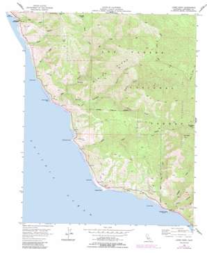
Lopez Point Topo Map California
To zoom in, hover over the map of Lopez Point
USGS Topo Quad 36121a5 - 1:24,000 scale
| Topo Map Name: | Lopez Point |
| USGS Topo Quad ID: | 36121a5 |
| Print Size: | ca. 21 1/4" wide x 27" high |
| Southeast Coordinates: | 36° N latitude / 121.5° W longitude |
| Map Center Coordinates: | 36.0625° N latitude / 121.5625° W longitude |
| U.S. State: | CA |
| Filename: | o36121a5.jpg |
| Download Map JPG Image: | Lopez Point topo map 1:24,000 scale |
| Map Type: | Topographic |
| Topo Series: | 7.5´ |
| Map Scale: | 1:24,000 |
| Source of Map Images: | United States Geological Survey (USGS) |
| Alternate Map Versions: |
Lopez Point CA 1956 Download PDF Buy paper map Lopez Point CA 1956, updated 1957 Download PDF Buy paper map Lopez Point CA 1956, updated 1960 Download PDF Buy paper map Lopez Point CA 1956, updated 1984 Download PDF Buy paper map Lopez Point CA 1995, updated 2000 Download PDF Buy paper map Lopez Point CA 2012 Download PDF Buy paper map Lopez Point CA 2015 Download PDF Buy paper map |
| FStopo: | US Forest Service topo Lopez Point is available: Download FStopo PDF Download FStopo TIF |
1:24,000 Topo Quads surrounding Lopez Point
> Back to 36121a1 at 1:100,000 scale
> Back to 36120a1 at 1:250,000 scale
> Back to U.S. Topo Maps home
Lopez Point topo map: Gazetteer
Lopez Point: Capes
Gamboa Point elevation 36m 118′Lopez Point elevation 27m 88′
Lopez Point: Islands
Dolan Rock elevation 0m 0′Harlan Rock elevation 1m 3′
Lopez Rock elevation 1m 3′
Square Black Rock elevation 1m 3′
Lopez Point: Parks
Limekiln State Park elevation 17m 55′Lopez Point: Populated Places
Lucia elevation 108m 354′Lopez Point: Post Offices
Lucia Post Office (historical) elevation 249m 816′Lopez Point: Ridges
Mining Ridge elevation 992m 3254′Lopez Point: Streams
Big Creek elevation 5m 16′Limekiln Creek elevation 8m 26′
North Fork Big Creek elevation 391m 1282′
Rat Creek elevation 28m 91′
Vicente Creek elevation 0m 0′
West Fork Limekiln Creek elevation 40m 131′
Lopez Point: Summits
Round Tree Hill elevation 920m 3018′Twin Peak elevation 1468m 4816′
Lopez Point: Trails
Gamboa Trail elevation 1081m 3546′North Coast Ridge Trail elevation 1383m 4537′
Lopez Point: Valleys
Devils Canyon elevation 36m 118′Hare Canyon elevation 40m 131′
Limekiln Canyon elevation 12m 39′
Middle Fork Devils Canyon elevation 251m 823′
North Fork Devils Canyon elevation 251m 823′
South Fork Devils Canyon elevation 397m 1302′
Lopez Point digital topo map on disk
Buy this Lopez Point topo map showing relief, roads, GPS coordinates and other geographical features, as a high-resolution digital map file on DVD:


