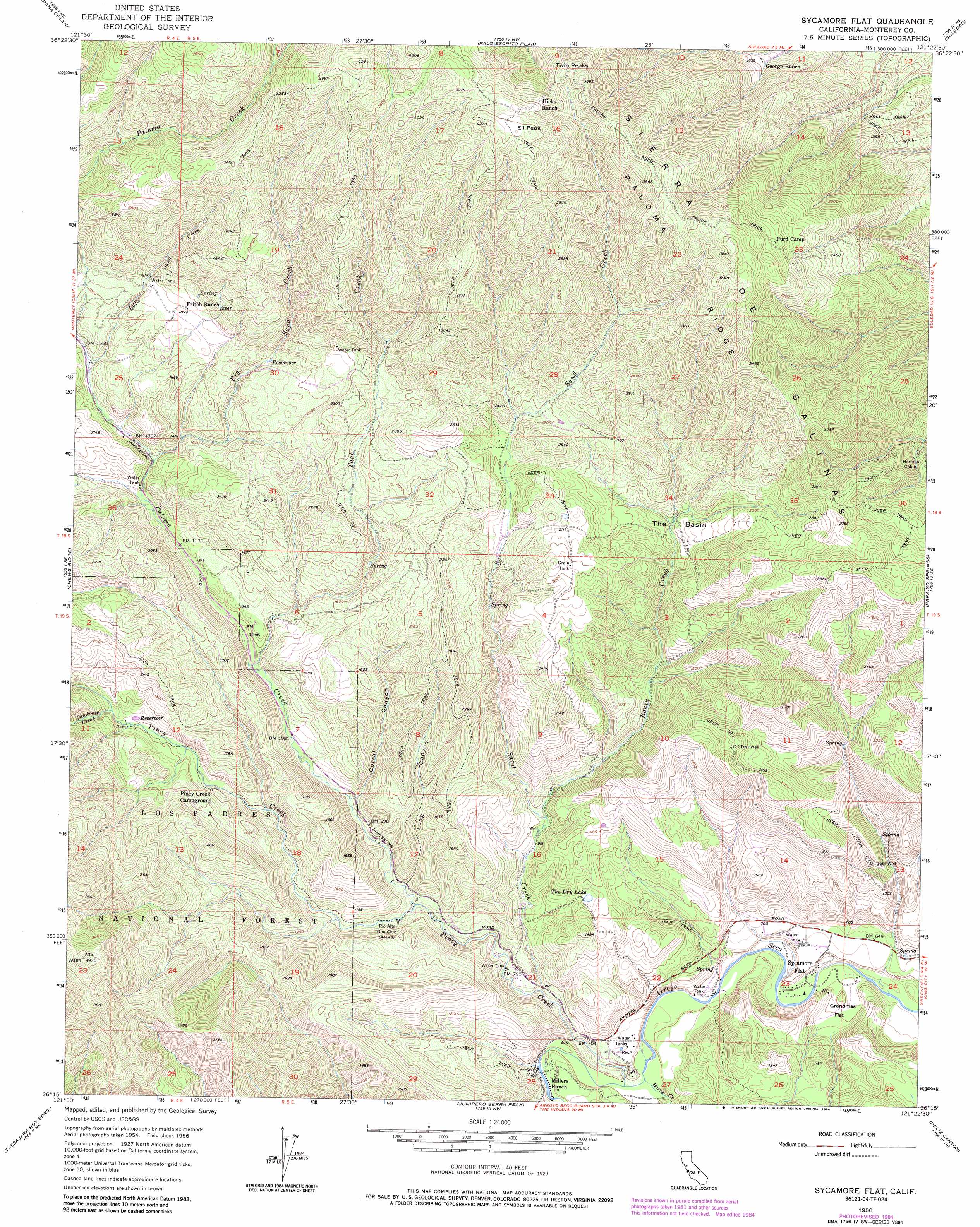
Sycamore Flat Topo Map California
To zoom in, hover over the map of Sycamore Flat
USGS Topo Quad 36121c4 - 1:24,000 scale
| Topo Map Name: | Sycamore Flat |
| USGS Topo Quad ID: | 36121c4 |
| Print Size: | ca. 21 1/4" wide x 27" high |
| Southeast Coordinates: | 36.25° N latitude / 121.375° W longitude |
| Map Center Coordinates: | 36.3125° N latitude / 121.4375° W longitude |
| U.S. State: | CA |
| Filename: | o36121c4.jpg |
| Download Map JPG Image: | Sycamore Flat topo map 1:24,000 scale |
| Map Type: | Topographic |
| Topo Series: | 7.5´ |
| Map Scale: | 1:24,000 |
| Source of Map Images: | United States Geological Survey (USGS) |
| Alternate Map Versions: |
Sycamore Flat CA 1956, updated 1958 Download PDF Buy paper map Sycamore Flat CA 1956, updated 1966 Download PDF Buy paper map Sycamore Flat CA 1956, updated 1977 Download PDF Buy paper map Sycamore Flat CA 1956, updated 1984 Download PDF Buy paper map Sycamore Flat CA 1995, updated 2000 Download PDF Buy paper map Sycamore Flat CA 2012 Download PDF Buy paper map Sycamore Flat CA 2015 Download PDF Buy paper map |
| FStopo: | US Forest Service topo Sycamore Flat is available: Download FStopo PDF Download FStopo TIF |
1:24,000 Topo Quads surrounding Sycamore Flat
Spreckels |
Chualar |
Gonzales |
Mount Johnson |
Bickmore Canyon |
Carmel Valley |
Rana Creek |
Palo Escrito Peak |
Soledad |
North Chalone Peak |
Ventana Cones |
Chews Ridge |
Sycamore Flat |
Paraiso Springs |
Greenfield |
Partington Ridge |
Tassajara Hot Springs |
Junipero Serra Peak |
Reliz Canyon |
Thompson Canyon |
Lopez Point |
Cone Peak |
Bear Canyon |
Cosio Knob |
> Back to 36121a1 at 1:100,000 scale
> Back to 36120a1 at 1:250,000 scale
> Back to U.S. Topo Maps home
Sycamore Flat topo map: Gazetteer
Sycamore Flat: Basins
The Basin elevation 498m 1633′Sycamore Flat: Flats
Grandmas Flat elevation 180m 590′Sycamore Flat: Lakes
The Dry Lake elevation 339m 1112′Sycamore Flat: Populated Places
Millers Ranch elevation 190m 623′Sycamore Flat elevation 188m 616′
Sycamore Flat: Ridges
Paloma Ridge elevation 1173m 3848′Sycamore Flat: Streams
Basin Creek elevation 291m 954′Big Sand Creek elevation 416m 1364′
Calaboose Creek elevation 445m 1459′
Horse Creek elevation 174m 570′
Little Sand Creek elevation 466m 1528′
Paloma Creek elevation 261m 856′
Piney Creek elevation 178m 583′
Sand Creek elevation 208m 682′
Tash Creek elevation 349m 1145′
Sycamore Flat: Summits
Ell Peak elevation 1297m 4255′Twin Peaks elevation 1202m 3943′
Sycamore Flat: Valleys
Corral Canyon elevation 310m 1017′Horse Canyon elevation 179m 587′
Long Canyon elevation 276m 905′
Sycamore Flat digital topo map on disk
Buy this Sycamore Flat topo map showing relief, roads, GPS coordinates and other geographical features, as a high-resolution digital map file on DVD: