Palo Escrito Peak Topo Map California
To zoom in, hover over the map of Palo Escrito Peak
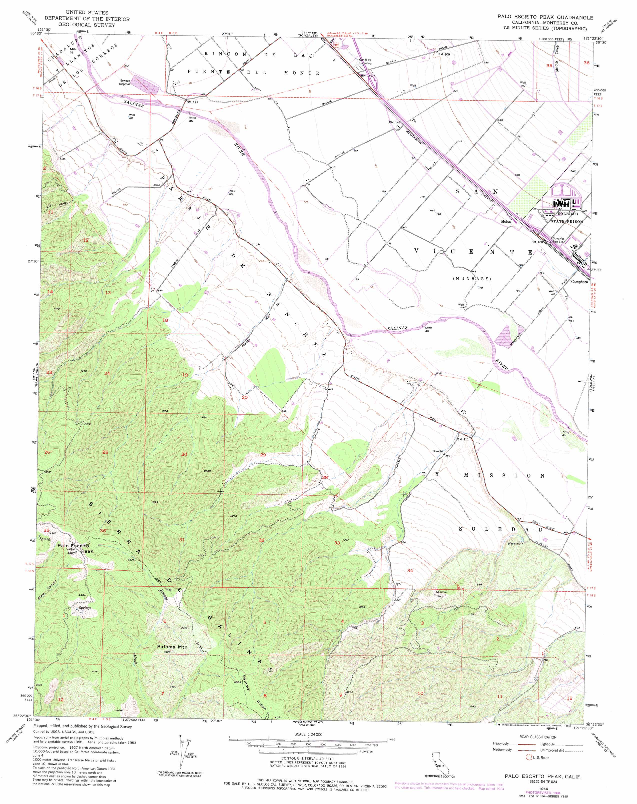
USGS Topo Quad 36121d4 - 1:24,000 scale
| Topo Map Name: | Palo Escrito Peak |
| USGS Topo Quad ID: | 36121d4 |
| Print Size: | ca. 21 1/4" wide x 27" high |
| Southeast Coordinates: | 36.375° N latitude / 121.375° W longitude |
| Map Center Coordinates: | 36.4375° N latitude / 121.4375° W longitude |
| U.S. State: | CA |
| Filename: | o36121d4.jpg |
| Download Map JPG Image: | Palo Escrito Peak topo map 1:24,000 scale |
| Map Type: | Topographic |
| Topo Series: | 7.5´ |
| Map Scale: | 1:24,000 |
| Source of Map Images: | United States Geological Survey (USGS) |
| Alternate Map Versions: |
Palo Escrito Peak CA 1956, updated 1956 Download PDF Buy paper map Palo Escrito Peak CA 1956, updated 1966 Download PDF Buy paper map Palo Escrito Peak CA 1956, updated 1982 Download PDF Buy paper map Palo Escrito Peak CA 1956, updated 1984 Download PDF Buy paper map Palo Escrito Peak CA 1956, updated 1986 Download PDF Buy paper map Palo Escrito Peak CA 2012 Download PDF Buy paper map Palo Escrito Peak CA 2015 Download PDF Buy paper map |
1:24,000 Topo Quads surrounding Palo Escrito Peak
Salinas |
Natividad |
Mount Harlan |
Paicines |
Cherry Peak |
Spreckels |
Chualar |
Gonzales |
Mount Johnson |
Bickmore Canyon |
Carmel Valley |
Rana Creek |
Palo Escrito Peak |
Soledad |
North Chalone Peak |
Ventana Cones |
Chews Ridge |
Sycamore Flat |
Paraiso Springs |
Greenfield |
Partington Ridge |
Tassajara Hot Springs |
Junipero Serra Peak |
Reliz Canyon |
Thompson Canyon |
> Back to 36121a1 at 1:100,000 scale
> Back to 36120a1 at 1:250,000 scale
> Back to U.S. Topo Maps home
Palo Escrito Peak topo map: Gazetteer
Palo Escrito Peak: Populated Places
Molus elevation 51m 167′Palo Escrito Peak: Ranges
Sierra de Salinas elevation 1354m 4442′Palo Escrito Peak: Streams
McCoy Creek elevation 110m 360′Palo Escrito Peak: Summits
Palo Escrito Peak elevation 1352m 4435′Paloma Mountain elevation 1207m 3959′
Palo Escrito Peak digital topo map on disk
Buy this Palo Escrito Peak topo map showing relief, roads, GPS coordinates and other geographical features, as a high-resolution digital map file on DVD: