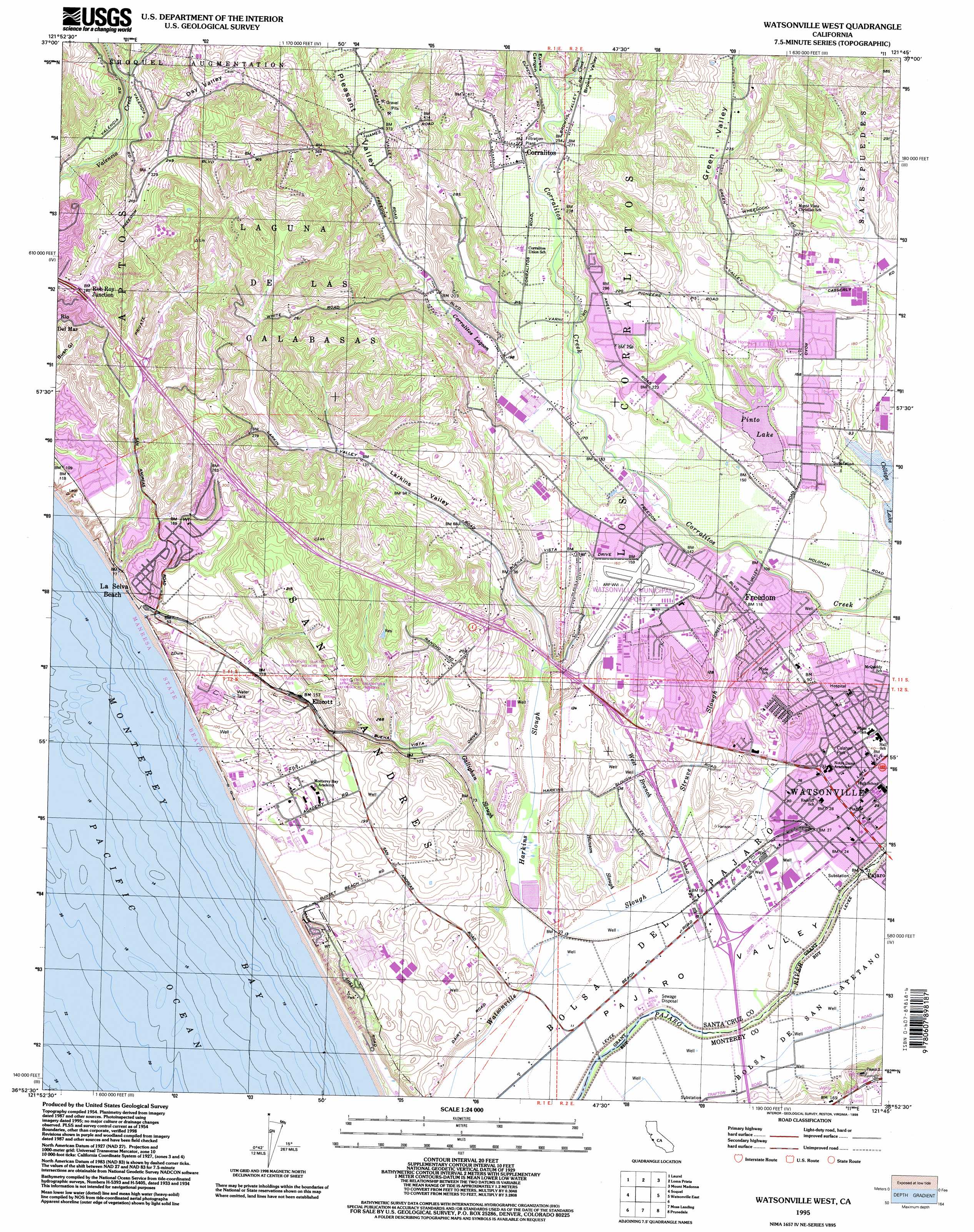
Watsonville West Topo Map California
To zoom in, hover over the map of Watsonville West
USGS Topo Quad 36121h7 - 1:24,000 scale
| Topo Map Name: | Watsonville West |
| USGS Topo Quad ID: | 36121h7 |
| Print Size: | ca. 21 1/4" wide x 27" high |
| Southeast Coordinates: | 36.875° N latitude / 121.75° W longitude |
| Map Center Coordinates: | 36.9375° N latitude / 121.8125° W longitude |
| U.S. State: | CA |
| Filename: | o36121h7.jpg |
| Download Map JPG Image: | Watsonville West topo map 1:24,000 scale |
| Map Type: | Topographic |
| Topo Series: | 7.5´ |
| Map Scale: | 1:24,000 |
| Source of Map Images: | United States Geological Survey (USGS) |
| Alternate Map Versions: |
Watsonville West CA 1954, updated 1955 Download PDF Buy paper map Watsonville West CA 1954, updated 1965 Download PDF Buy paper map Watsonville West CA 1954, updated 1969 Download PDF Buy paper map Watsonville West CA 1954, updated 1981 Download PDF Buy paper map Watsonville West CA 1954, updated 1984 Download PDF Buy paper map Watsonville West CA 1954, updated 1994 Download PDF Buy paper map Watsonville West CA 1995, updated 1998 Download PDF Buy paper map Watsonville West CA 2012 Download PDF Buy paper map Watsonville West CA 2015 Download PDF Buy paper map |
1:24,000 Topo Quads surrounding Watsonville West
Castle Rock Ridge |
Los Gatos |
Santa Teresa Hills |
Morgan Hill |
Mount Sizer |
Felton |
Laurel |
Loma Prieta |
Mount Madonna |
Gilroy |
Santa Cruz |
Soquel |
Watsonville West |
Watsonville East |
Chittenden |
Moss Landing |
Prunedale |
San Juan Bautista |
||
Marina |
Salinas |
Natividad |
> Back to 36121e1 at 1:100,000 scale
> Back to 36120a1 at 1:250,000 scale
> Back to U.S. Topo Maps home
Watsonville West topo map: Gazetteer
Watsonville West: Airports
Alta Vista Heliport elevation 139m 456′Monterey Bay Academy Airport elevation 17m 55′
Watsonville Community Hospital Heliport elevation 40m 131′
Watsonville Municipal Airport elevation 46m 150′
Watsonville West: Beaches
Sunset Beach elevation 3m 9′Watsonville West: Lakes
Corralitos Lagoon elevation 60m 196′Watsonville West: Parks
Callaghan Park elevation 13m 42′Crestview Park elevation 30m 98′
Ellicott Slough National Wildlife Refuge elevation 86m 282′
Flodberg Park elevation 25m 82′
Manresa State Beach elevation 9m 29′
Mesa Village Park elevation 58m 190′
Pinto Lake City Park elevation 37m 121′
Pinto Lake County Park elevation 52m 170′
Ramsay Park elevation 8m 26′
Santa Cruz Long-Toed Salamander Ecological Reserve elevation 65m 213′
Scott County Park elevation 61m 200′
Second Street Playground elevation 9m 29′
Sunset State Beach elevation 6m 19′
The Glass House State Historic Landmark elevation 50m 164′
Watsonville Plaza elevation 10m 32′
Watsonville State Wildlife Area elevation 2m 6′
Watsonville West: Populated Places
Amesti elevation 45m 147′Aptos Hills elevation 66m 216′
Colache Town elevation 12m 39′
Corralitos elevation 82m 269′
El Cerrito Mobile Home Park elevation 16m 52′
Ellicott elevation 47m 154′
Freedom elevation 38m 124′
La Selva Beach elevation 25m 82′
Larkin Valley elevation 23m 75′
Leonard (historical) elevation 44m 144′
Meadows Manor Mobile Home Park elevation 33m 108′
Monterey Vista Mobile Home Park elevation 41m 134′
Nuga (historical) elevation 4m 13′
Port Watsonvile elevation 46m 150′
Portola Heights Mobile Home Park elevation 12m 39′
Rob Roy Junction elevation 43m 141′
Strongs Mobile Village elevation 48m 157′
Watsonville elevation 10m 32′
Watsonville West: Post Offices
Freedom Post Office elevation 40m 131′Watsonville Post Office elevation 10m 32′
Watsonville West: Reservoirs
Pinto Lake elevation 34m 111′Watsonville West: Streams
Browns Creek elevation 79m 259′Gallighan Slough elevation 3m 9′
Hanson Slough elevation 3m 9′
Harkins Slough elevation 4m 13′
Struve Slough elevation 4m 13′
West Branch Struve Slough elevation 2m 6′
Watsonville West: Valleys
Browns Valley elevation 93m 305′Day Valley elevation 80m 262′
Eureka Canyon elevation 83m 272′
Green Valley elevation 53m 173′
Larkins Valley elevation 20m 65′
Pleasant Valley elevation 83m 272′
Watsonville West: Woods
Ollason Grove elevation 88m 288′Watsonville West digital topo map on disk
Buy this Watsonville West topo map showing relief, roads, GPS coordinates and other geographical features, as a high-resolution digital map file on DVD: