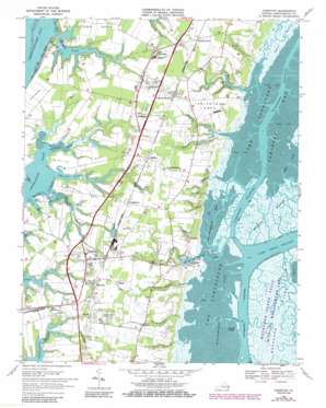
Cheriton Topo Map Virginia
To zoom in, hover over the map of Cheriton
USGS Topo Quad 37075c8 - 1:24,000 scale
| Topo Map Name: | Cheriton |
| USGS Topo Quad ID: | 37075c8 |
| Print Size: | ca. 21 1/4" wide x 27" high |
| Southeast Coordinates: | 37.25° N latitude / 75.875° W longitude |
| Map Center Coordinates: | 37.3125° N latitude / 75.9375° W longitude |
| U.S. State: | VA |
| Filename: | o37075c8.jpg |
| Download Map JPG Image: | Cheriton topo map 1:24,000 scale |
| Map Type: | Topographic |
| Topo Series: | 7.5´ |
| Map Scale: | 1:24,000 |
| Source of Map Images: | United States Geological Survey (USGS) |
| Alternate Map Versions: |
Cheriton VA 1942 Download PDF Buy paper map Cheriton VA 1955, updated 1956 Download PDF Buy paper map Cheriton VA 1968, updated 1971 Download PDF Buy paper map Cheriton VA 1968, updated 1981 Download PDF Buy paper map Cheriton VA 1968, updated 1986 Download PDF Buy paper map Cheriton VA 1977, updated 1982 Download PDF Buy paper map Cheriton VA 2011 Download PDF Buy paper map Cheriton VA 2013 Download PDF Buy paper map Cheriton VA 2016 Download PDF Buy paper map |
1:24,000 Topo Quads surrounding Cheriton
> Back to 37075a1 at 1:100,000 scale
> Back to 37074a1 at 1:250,000 scale
> Back to U.S. Topo Maps home
Cheriton topo map: Gazetteer
Cheriton: Airports
Cherrystone Airport elevation 2m 6′Eagles Nest Airport elevation 11m 36′
Cheriton: Bays
Brockenberry Bay elevation 0m 0′Crow Bay elevation 0m 0′
Mockhorn Bay elevation 0m 0′
Ramshorn Bay elevation 0m 0′
The Gulf elevation 0m 0′
Cheriton: Beaches
Smith Beach elevation 0m 0′Wilkins Beach elevation 4m 13′
Cheriton: Capes
Eyrehall Neck elevation 4m 13′Eyreville Neck elevation 3m 9′
Holt Neck elevation 1m 3′
Indiantown Neck elevation 9m 29′
Old Town Neck elevation 4m 13′
Cheriton: Channels
Narrow Channel elevation 0m 0′Newhall Channel elevation 0m 0′
Oyster Slip elevation 0m 0′
Point of Rock Channel elevation 0m 0′
Ramshorn Channel elevation 0m 0′
Cheriton: Cliffs
White Cliffs elevation 6m 19′Cheriton: Dams
Jones Dam Number One elevation 2m 6′Jones Dam Number Two elevation 3m 9′
Kellam Dam elevation 0m 0′
Smith Dam elevation 3m 9′
Cheriton: Parks
Indiantown Recreation Park elevation 3m 9′Mockhorn Island State Wildlife Management Area elevation 1m 3′
Northampton County Courthouse Historic District elevation 9m 29′
Cheriton: Populated Places
Bayview elevation 8m 26′Beverly elevation 11m 36′
Cape Junction elevation 5m 16′
Cheriton elevation 6m 19′
Chesapeake elevation 11m 36′
Culls elevation 10m 32′
Eastville elevation 9m 29′
Eastville Station elevation 12m 39′
Fairview elevation 9m 29′
James Crossroads elevation 9m 29′
Kendall Grove elevation 12m 39′
Kendall Grove Estates elevation 11m 36′
Little Salisbury elevation 10m 32′
Nottingham elevation 8m 26′
Oyster elevation 1m 3′
Pat Town elevation 11m 36′
Seaview elevation 10m 32′
Simpkins elevation 12m 39′
Smith Beach elevation 6m 19′
Stumptown elevation 10m 32′
The Meadows elevation 11m 36′
Cheriton: Post Offices
Cheriton Post Office elevation 6m 19′Chesapeake Post Office (historical) elevation 11m 36′
Eastville Post Office elevation 9m 29′
Oyster Post Office elevation 1m 3′
Seaview Post Office elevation 9m 29′
Cheriton: Reservoirs
Kellam Pond elevation 0m 0′Smith Pond elevation 3m 9′
Cheriton: Streams
Brockenberry Creek elevation -1m -4′Cobb Mill Creek elevation 0m 0′
Eyrehall Creek elevation 0m 0′
Eyreville Creek elevation 0m 0′
Indiantown Creek elevation 0m 0′
Narrow Channel Branch elevation 0m 0′
Newhall Channel Drain elevation 1m 3′
Old Castle Creek elevation 0m 0′
Point of Rock Drain elevation 1m 3′
Spady Creek elevation 1m 3′
Taylor Creek elevation 0m 0′
Thomas Creek elevation 5m 16′
Wilkins Creek elevation 2m 6′
Cheriton digital topo map on disk
Buy this Cheriton topo map showing relief, roads, GPS coordinates and other geographical features, as a high-resolution digital map file on DVD:
Atlantic Coast (NY, NJ, PA, DE, MD, VA, NC)
Buy digital topo maps: Atlantic Coast (NY, NJ, PA, DE, MD, VA, NC)


