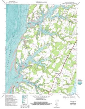
Franktown Topo Map Virginia
To zoom in, hover over the map of Franktown
USGS Topo Quad 37075d8 - 1:24,000 scale
| Topo Map Name: | Franktown |
| USGS Topo Quad ID: | 37075d8 |
| Print Size: | ca. 21 1/4" wide x 27" high |
| Southeast Coordinates: | 37.375° N latitude / 75.875° W longitude |
| Map Center Coordinates: | 37.4375° N latitude / 75.9375° W longitude |
| U.S. State: | VA |
| Filename: | o37075d8.jpg |
| Download Map JPG Image: | Franktown topo map 1:24,000 scale |
| Map Type: | Topographic |
| Topo Series: | 7.5´ |
| Map Scale: | 1:24,000 |
| Source of Map Images: | United States Geological Survey (USGS) |
| Alternate Map Versions: |
Franktown VA 1943, updated 1963 Download PDF Buy paper map Franktown VA 1968, updated 1971 Download PDF Buy paper map Franktown VA 1968, updated 1987 Download PDF Buy paper map Franktown VA 1968, updated 1992 Download PDF Buy paper map Franktown VA 1977, updated 1982 Download PDF Buy paper map Franktown VA 2011 Download PDF Buy paper map Franktown VA 2013 Download PDF Buy paper map Franktown VA 2016 Download PDF Buy paper map |
1:24,000 Topo Quads surrounding Franktown
> Back to 37075a1 at 1:100,000 scale
> Back to 37074a1 at 1:250,000 scale
> Back to U.S. Topo Maps home
Franktown topo map: Gazetteer
Franktown: Airports
Kellam Field elevation 12m 39′Franktown: Bays
Holly Grove Cove elevation 2m 6′Paraplane Cove elevation 1m 3′
Franktown: Beaches
Hungars Beach elevation 0m 0′Franktown: Capes
Church Neck elevation 5m 16′Church Point elevation 0m 0′
Elliotts Neck elevation 5m 16′
Great Neck elevation 3m 9′
Gull Point elevation 0m 0′
Jacobus Point elevation 3m 9′
Long Point elevation 0m 0′
Nassawadox Point elevation 0m 0′
Shooting Point elevation 0m 0′
Sparrow Point elevation 0m 0′
The Saltworks elevation 3m 9′
Vaucluse Point elevation 2m 6′
Waterford Point elevation 2m 6′
Wellington Neck elevation 7m 22′
Wilson Neck elevation 5m 16′
Franktown: Dams
Mears Dam elevation 4m 13′Miller Dam elevation 1m 3′
Franktown: Guts
Masden Gut elevation 0m 0′Franktown: Islands
Honeymoon Island elevation 1m 3′Horse Island elevation 2m 6′
South Island elevation 0m 0′
Franktown: Populated Places
Bayford elevation 4m 13′Bayleys Neck Farm elevation 5m 16′
Birdsnest elevation 11m 36′
Bridgetown elevation 3m 9′
Cardinal Estates elevation 8m 26′
Church Creek Point elevation 6m 19′
Deerfield Estates elevation 6m 19′
Franktown elevation 7m 22′
Harbour Point elevation 4m 13′
Hideaway Cove elevation 5m 16′
Hungars Point elevation 3m 9′
Johnsontown elevation 6m 19′
Machipongo elevation 12m 39′
Martins Siding elevation 12m 39′
Peaceful Beach Estates elevation 3m 9′
Reedtown elevation 12m 39′
Shadyside elevation 11m 36′
Silver Beach elevation 3m 9′
Solitude Trails elevation 6m 19′
Treherneville elevation 12m 39′
Vaucluse Shores elevation 1m 3′
Westerhouse Woods elevation 3m 9′
Franktown: Post Offices
Birdsnest Post Office elevation 12m 39′Franktown Post Office elevation 7m 22′
Machipongo Post Office elevation 12m 39′
Franktown: Reservoirs
Mears Pond elevation 4m 13′Miller Pond elevation 1m 3′
Franktown: Streams
Barlow Creek elevation 0m 0′Church Creek elevation 0m 0′
Hungars Creek elevation 0m 0′
Jacobus Creek elevation 0m 0′
Mattawoman Creek elevation 0m 0′
Nassawadox Creek elevation 0m 0′
Warehouse Creek elevation 0m 0′
Westerhouse Creek elevation -2m -7′
Franktown digital topo map on disk
Buy this Franktown topo map showing relief, roads, GPS coordinates and other geographical features, as a high-resolution digital map file on DVD:
Atlantic Coast (NY, NJ, PA, DE, MD, VA, NC)
Buy digital topo maps: Atlantic Coast (NY, NJ, PA, DE, MD, VA, NC)


