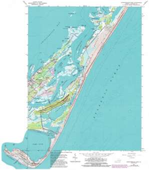
Chincoteague East Topo Map Virginia
To zoom in, hover over the map of Chincoteague East
USGS Topo Quad 37075h3 - 1:24,000 scale
| Topo Map Name: | Chincoteague East |
| USGS Topo Quad ID: | 37075h3 |
| Print Size: | ca. 21 1/4" wide x 27" high |
| Southeast Coordinates: | 37.875° N latitude / 75.25° W longitude |
| Map Center Coordinates: | 37.9375° N latitude / 75.3125° W longitude |
| U.S. State: | VA |
| Filename: | o37075h3.jpg |
| Download Map JPG Image: | Chincoteague East topo map 1:24,000 scale |
| Map Type: | Topographic |
| Topo Series: | 7.5´ |
| Map Scale: | 1:24,000 |
| Source of Map Images: | United States Geological Survey (USGS) |
| Alternate Map Versions: |
Chincoteague East VA 1942, updated 1962 Download PDF Buy paper map Chincoteague East VA 1965, updated 1966 Download PDF Buy paper map Chincoteague East VA 1965, updated 1975 Download PDF Buy paper map Chincoteague East VA 1965, updated 1981 Download PDF Buy paper map Chincoteague East VA 1965, updated 1986 Download PDF Buy paper map Chincoteague East VA 1978, updated 1983 Download PDF Buy paper map Chincoteague East VA 1999, updated 2000 Download PDF Buy paper map Chincoteague East VA 2011 Download PDF Buy paper map Chincoteague East VA 2013 Download PDF Buy paper map Chincoteague East VA 2016 Download PDF Buy paper map |
1:24,000 Topo Quads surrounding Chincoteague East
Dividing Creek |
Snow Hill |
Public Landing |
Tingles Island |
|
Pocomoke City |
Girdletree |
Boxiron |
Whittington Point |
|
Hallwood |
Chincoteague West |
Chincoteague East |
||
Bloxom |
Wallops Island |
|||
Metompkin Inlet |
> Back to 37075e1 at 1:100,000 scale
> Back to 37074a1 at 1:250,000 scale
> Back to U.S. Topo Maps home
Chincoteague East topo map: Gazetteer
Chincoteague East: Bars
Vineyard Shoal elevation 0m 0′Chincoteague East: Bays
Archie Cove elevation 0m 0′Assateague Bay elevation 0m 0′
Blake Cove elevation 0m 0′
Booths Bay elevation 0m 0′
Calfpen Bay elevation 0m 0′
Cherrytree Hill Bay elevation 0m 0′
Greenbank Bay elevation 0m 0′
Harmon Cove elevation 0m 0′
Little Harmon Cove elevation 0m 0′
Little Oyster Bay elevation 0m 0′
Little Toms Cove elevation 0m 0′
Oyster Bay elevation 0m 0′
Smith Bay elevation 0m 0′
Toms Cove elevation 0m 0′
Chincoteague East: Beaches
Bow Beach elevation 1m 3′Chincoteague East: Capes
Blake Point elevation 0m 0′Jim Blades Point elevation 0m 0′
Mink Tump Point elevation 0m 0′
Smith Bay Tumps elevation 0m 0′
Wildcat Point elevation 0m 0′
Chincoteague East: Channels
Assateague Channel elevation 0m 0′The Will Hole elevation 0m 0′
Chincoteague East: Guts
East Gut elevation 0m 0′Sign Gut elevation 0m 0′
Smalley Drain elevation 0m 0′
Wildcat Gut elevation 0m 0′
Chincoteague East: Islands
Chincoteague Island elevation 1m 3′Morris Island elevation 0m 0′
Piney Island elevation 1m 3′
Smith Hammocks elevation 1m 3′
Thurf Marsh Islands elevation 0m 0′
Chincoteague East: Lakes
Hairy Head Pond elevation 0m 0′Chincoteague East: Parks
Chincoteague National Wildlife Refuge elevation 1m 3′Chincoteague East: Populated Places
Birch Town elevation 2m 6′Deep Hole elevation 1m 3′
Chincoteague East: Post Offices
Chincoteague Island Post Office elevation 1m 3′Chincoteague East: Streams
Deep Hole Creek elevation 0m 0′Eel Creek elevation 0m 0′
Janeys Creek elevation 0m 0′
Little Morris Island Creek elevation 0m 0′
Morris Island Creek elevation 0m 0′
Peach Creek elevation 0m 0′
Sheepshead Creek elevation 1m 3′
Chincoteague East: Summits
Cherrytree Hill elevation 1m 3′Chincoteague East: Swamps
Black Duck Marsh elevation 1m 3′Carrs Marsh elevation 2m 6′
Coards Marshes elevation 0m 0′
Janeys Creek Marsh elevation 0m 0′
Ragged Point Marshes elevation 0m 0′
Wildcat Marsh elevation 0m 0′
Chincoteague East: Trails
Ragged Point Trail elevation 1m 3′Chincoteague East: Woods
Woods Grove elevation 0m 0′Chincoteague East digital topo map on disk
Buy this Chincoteague East topo map showing relief, roads, GPS coordinates and other geographical features, as a high-resolution digital map file on DVD:
Atlantic Coast (NY, NJ, PA, DE, MD, VA, NC)
Buy digital topo maps: Atlantic Coast (NY, NJ, PA, DE, MD, VA, NC)


