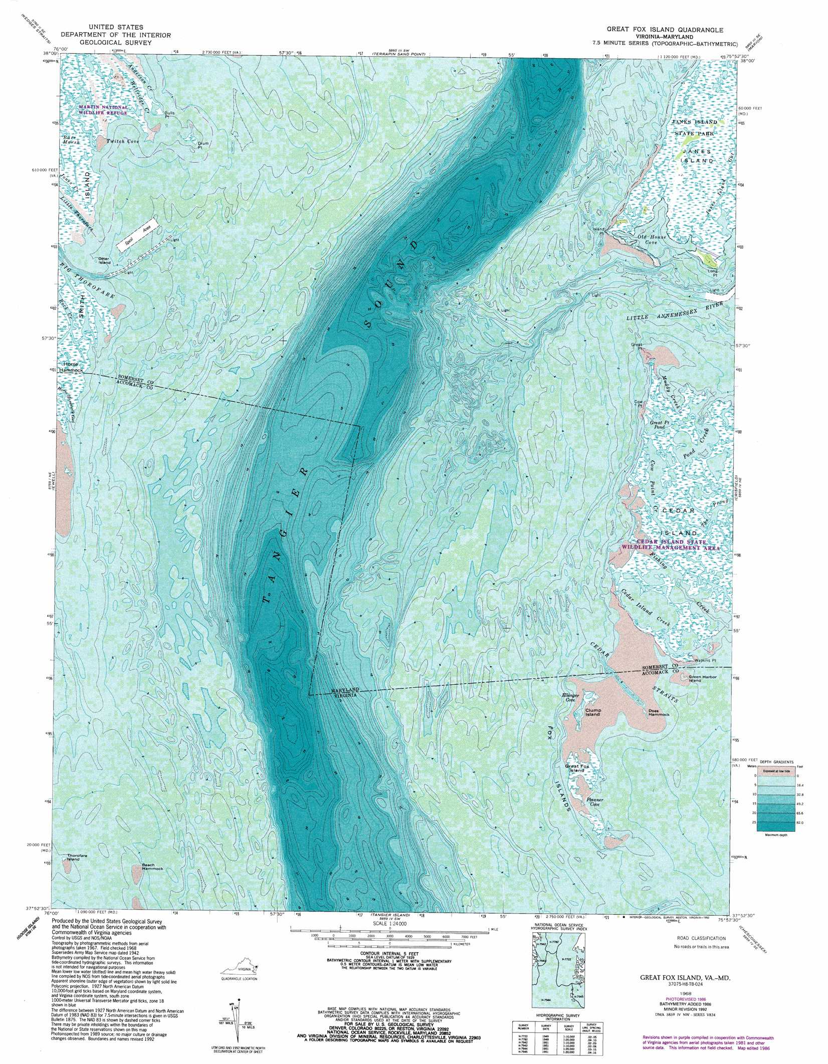
Great Fox Island Topo Map Maryland
To zoom in, hover over the map of Great Fox Island
USGS Topo Quad 37075h8 - 1:24,000 scale
| Topo Map Name: | Great Fox Island |
| USGS Topo Quad ID: | 37075h8 |
| Print Size: | ca. 21 1/4" wide x 27" high |
| Southeast Coordinates: | 37.875° N latitude / 75.875° W longitude |
| Map Center Coordinates: | 37.9375° N latitude / 75.9375° W longitude |
| U.S. States: | MD, VA |
| Filename: | o37075h8.jpg |
| Download Map JPG Image: | Great Fox Island topo map 1:24,000 scale |
| Map Type: | Topographic |
| Topo Series: | 7.5´ |
| Map Scale: | 1:24,000 |
| Source of Map Images: | United States Geological Survey (USGS) |
| Alternate Map Versions: |
Great Fox Island VA 1942, updated 1957 Download PDF Buy paper map Great Fox Island VA 1968, updated 1971 Download PDF Buy paper map Great Fox Island VA 1968, updated 1987 Download PDF Buy paper map Great Fox Island VA 1968, updated 1992 Download PDF Buy paper map Great Fox Island VA 2011 Download PDF Buy paper map Great Fox Island VA 2013 Download PDF Buy paper map Great Fox Island VA 2016 Download PDF Buy paper map |
1:24,000 Topo Quads surrounding Great Fox Island
Richland Point |
Bloodsworth Island |
Deal Island |
Monie |
Princess Anne |
East Of Point Lookout |
Kedges Straits |
Terrapin Sand Point |
Marion |
Kingston |
Smith Point |
Ewell |
Great Fox Island |
Crisfield |
Saxis |
East of Reedville |
Goose Island |
Tangier Island |
Chesconessex |
Parksley |
East of Fleets Bay |
West Of Nandua Creek |
Nandua Creek |
Pungoteague |
Accomac |
> Back to 37075e1 at 1:100,000 scale
> Back to 37074a1 at 1:250,000 scale
> Back to U.S. Topo Maps home
Great Fox Island topo map: Gazetteer
Great Fox Island: Bays
Anderson Creek elevation 0m 0′Cedar Island Creek elevation -3m -10′
Cow Point Creek elevation 0m 0′
Ellinger Cove elevation 0m 0′
Muddy Creek elevation -3m -10′
Old House Cove elevation 0m 0′
Planner Cove elevation 1m 3′
Pond Creek elevation -3m -10′
Twitch Cove elevation 0m 0′
Wellridge Creek elevation 0m 0′
Great Fox Island: Capes
Bulls Point elevation 0m 0′Cow Point elevation 0m 0′
Drum Point elevation 0m 0′
Great Point elevation 0m 0′
Horse Hammock Point elevation 0m 0′
Island Point elevation 1m 3′
Long Point elevation 1m 3′
Watkins Point elevation 1m 3′
Watkins Pointe (historical) elevation 0m 0′
Great Fox Island: Channels
Cedar Straits elevation 0m 0′Cedar Straits elevation 0m 0′
Green Straits elevation 0m 0′
Green Straits elevation 0m 0′
Little Thorofare elevation 1m 3′
Great Fox Island: Guts
Fishing Creek elevation -3m -10′Horse Hammock Gut elevation 0m 0′
Janes Island Gut elevation 1m 3′
Rock Creek elevation 0m 0′
Great Fox Island: Islands
Cedar Island elevation 1m 3′Clump Island elevation 4m 13′
Does Hammock elevation 0m 0′
Fox Islands elevation 1m 3′
Great Fox Island elevation 1m 3′
Green Harbor Island elevation 0m 0′
Horse Hammock elevation 0m 0′
House Island elevation 0m 0′
Otter Island elevation 0m 0′
Reach Hammock elevation 0m 0′
Thorofare Island elevation 0m 0′
Thorofare Island elevation 0m 0′
Yorkshire Island (historical) elevation 0m 0′
Great Fox Island: Lakes
Great Point Pond elevation -3m -10′Great Fox Island: Parks
Cedar Island State Wildlife Management Area elevation 0m 0′Great Fox Island: Streams
Little Annemessex River elevation 0m 0′Great Fox Island digital topo map on disk
Buy this Great Fox Island topo map showing relief, roads, GPS coordinates and other geographical features, as a high-resolution digital map file on DVD:
Atlantic Coast (NY, NJ, PA, DE, MD, VA, NC)
Buy digital topo maps: Atlantic Coast (NY, NJ, PA, DE, MD, VA, NC)
 map DVD")