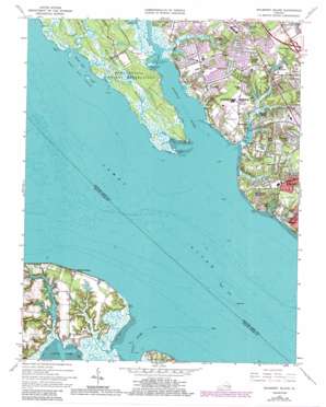
Mulberry Island Topo Map Virginia
To zoom in, hover over the map of Mulberry Island
USGS Topo Quad 37076a5 - 1:24,000 scale
| Topo Map Name: | Mulberry Island |
| USGS Topo Quad ID: | 37076a5 |
| Print Size: | ca. 21 1/4" wide x 27" high |
| Southeast Coordinates: | 37° N latitude / 76.5° W longitude |
| Map Center Coordinates: | 37.0625° N latitude / 76.5625° W longitude |
| U.S. State: | VA |
| Filename: | o37076a5.jpg |
| Download Map JPG Image: | Mulberry Island topo map 1:24,000 scale |
| Map Type: | Topographic |
| Topo Series: | 7.5´ |
| Map Scale: | 1:24,000 |
| Source of Map Images: | United States Geological Survey (USGS) |
| Alternate Map Versions: |
Mulberry Island VA 1950, updated 1953 Download PDF Buy paper map Mulberry Island VA 1957, updated 1960 Download PDF Buy paper map Mulberry Island VA 1965, updated 1967 Download PDF Buy paper map Mulberry Island VA 1965, updated 1971 Download PDF Buy paper map Mulberry Island VA 1965, updated 1974 Download PDF Buy paper map Mulberry Island VA 1965, updated 1980 Download PDF Buy paper map Mulberry Island VA 1965, updated 1984 Download PDF Buy paper map Mulberry Island VA 1965, updated 1986 Download PDF Buy paper map Mulberry Island VA 2011 Download PDF Buy paper map Mulberry Island VA 2013 Download PDF Buy paper map Mulberry Island VA 2016 Download PDF Buy paper map |
1:24,000 Topo Quads surrounding Mulberry Island
> Back to 37076a1 at 1:100,000 scale
> Back to 37076a1 at 1:250,000 scale
> Back to U.S. Topo Maps home
Mulberry Island topo map: Gazetteer
Mulberry Island: Airports
Aberdeen Field elevation 10m 32′Mulberry Island: Bays
Swash Hole elevation 0m 0′Mulberry Island: Capes
Blunt Point elevation 0m 0′Curtis Point elevation 1m 3′
Days Point elevation 0m 0′
Jail Point elevation 0m 0′
Marshy Point elevation 3m 9′
Rainbow Farm Point elevation 11m 36′
Thorofare Point elevation 0m 0′
Mulberry Island: Channels
Thorofare elevation 0m 0′Mulberry Island: Crossings
Interchange 255 elevation 12m 39′Mulberry Island: Dams
Aberdeen Dam elevation 0m 0′Sluice Dam elevation 4m 13′
Tormentor Dam elevation 0m 0′
Mulberry Island: Islands
Mulberry Island elevation 3m 9′Swash Hole Island elevation 0m 0′
Thorofare Island elevation 0m 0′
Mulberry Island: Parks
Denbigh Park elevation 1m 3′Nicewood Park elevation 9m 29′
Riverview Farm Park elevation 10m 32′
Mulberry Island: Populated Places
Barclay Woods elevation 9m 29′Beverly Hills elevation 9m 29′
Boxley Hills elevation 8m 26′
Burkdale elevation 10m 32′
Carriage Hill elevation 9m 29′
Chesapeake Village Mobile Home Park elevation 10m 32′
College Park elevation 11m 36′
Deep Creek elevation 8m 26′
Eastwood elevation 10m 32′
Edgewood elevation 9m 29′
Hidenwood elevation 10m 32′
Hoopes Landing elevation 1m 3′
Mammoth Oak elevation 8m 26′
Maple Grove elevation 9m 29′
Maxwell Garden elevation 7m 22′
Menchville elevation 9m 29′
Mennonite Colony elevation 8m 26′
Merry Point Estates elevation 8m 26′
Mogarts Beach elevation 10m 32′
Nicewood elevation 7m 22′
Old Orchard elevation 9m 29′
Oyster Point elevation 9m 29′
Pates Field (historical) elevation 13m 42′
Shore Park elevation 9m 29′
Walden elevation 11m 36′
Warwick Lawns elevation 6m 19′
Watergate Estates elevation 9m 29′
Wendwood elevation 10m 32′
Mulberry Island: Reservoirs
Aberdeen Pond elevation 0m 0′Indigo Lake elevation 2m 6′
Lake Queen Anne elevation 3m 9′
Lake Tormentor elevation 0m 0′
Sluice Millpond elevation 4m 13′
Tormento Lake elevation 3m 9′
Yoder Pond elevation 2m 6′
Mulberry Island: Streams
Beatty Creek elevation 0m 0′Deep Creek elevation 0m 0′
Fishers Creek elevation 1m 3′
Jail Creek elevation 0m 0′
Lukas Creek elevation 1m 3′
Morrisons Creek elevation 3m 9′
Pagan River elevation 0m 0′
Tormentor Creek elevation 0m 0′
Warwick River elevation 0m 0′
Williams Creek elevation 2m 6′
Mulberry Island digital topo map on disk
Buy this Mulberry Island topo map showing relief, roads, GPS coordinates and other geographical features, as a high-resolution digital map file on DVD:
Atlantic Coast (NY, NJ, PA, DE, MD, VA, NC)
Buy digital topo maps: Atlantic Coast (NY, NJ, PA, DE, MD, VA, NC)


