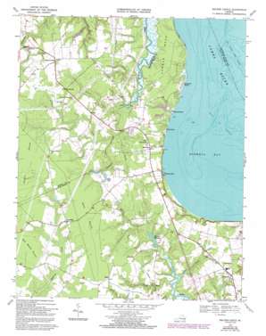
Bacons Castle Topo Map Virginia
To zoom in, hover over the map of Bacons Castle
USGS Topo Quad 37076a6 - 1:24,000 scale
| Topo Map Name: | Bacons Castle |
| USGS Topo Quad ID: | 37076a6 |
| Print Size: | ca. 21 1/4" wide x 27" high |
| Southeast Coordinates: | 37° N latitude / 76.625° W longitude |
| Map Center Coordinates: | 37.0625° N latitude / 76.6875° W longitude |
| U.S. State: | VA |
| Filename: | o37076a6.jpg |
| Download Map JPG Image: | Bacons Castle topo map 1:24,000 scale |
| Map Type: | Topographic |
| Topo Series: | 7.5´ |
| Map Scale: | 1:24,000 |
| Source of Map Images: | United States Geological Survey (USGS) |
| Alternate Map Versions: |
Bacons Castle VA 1948, updated 1953 Download PDF Buy paper map Bacons Castle VA 1957, updated 1960 Download PDF Buy paper map Bacons Castle VA 1969, updated 1971 Download PDF Buy paper map Bacons Castle VA 1969, updated 1986 Download PDF Buy paper map Bacons Castle VA 1969, updated 1992 Download PDF Buy paper map Bacons Castle VA 2010 Download PDF Buy paper map Bacons Castle VA 2013 Download PDF Buy paper map Bacons Castle VA 2016 Download PDF Buy paper map |
1:24,000 Topo Quads surrounding Bacons Castle
> Back to 37076a1 at 1:100,000 scale
> Back to 37076a1 at 1:250,000 scale
> Back to U.S. Topo Maps home
Bacons Castle topo map: Gazetteer
Bacons Castle: Bars
Point Shoals elevation 0m 0′Bacons Castle: Bays
Burwell Bay elevation 0m 0′Bacons Castle: Bridges
Burnt Mill Bridge elevation 4m 13′Bacons Castle: Capes
Lawnes Neck elevation 8m 26′Bacons Castle: Channels
Rock Landing Shoal Channel elevation 0m 0′Bacons Castle: Dams
Gail Dam elevation 9m 29′Wrenns Dam elevation 5m 16′
Bacons Castle: Populated Places
Baileys Beach elevation 0m 0′Burwell Bay elevation 0m 0′
Genovar elevation 20m 65′
Holly Point elevation 0m 0′
Lawson elevation 20m 65′
Moonlight elevation 24m 78′
Pooles Mobile Home Park elevation 19m 62′
Poolesville elevation 27m 88′
Rushmere elevation 22m 72′
Rushmere Shores elevation 4m 13′
Septa elevation 24m 78′
Tylers Beach elevation 9m 29′
Bacons Castle: Reservoirs
Slade Pond elevation 9m 29′Wrenns Millpond elevation 5m 16′
Bacons Castle: Streams
Canal Run elevation 1m 3′Lawson Creek elevation 1m 3′
Pierce Creek elevation 1m 3′
Pooles Creek elevation 4m 13′
Warren Creek elevation 5m 16′
Bacons Castle: Swamps
Belle Meadow Pocosin elevation 24m 78′Pettit Pocosin elevation 25m 82′
Bacons Castle digital topo map on disk
Buy this Bacons Castle topo map showing relief, roads, GPS coordinates and other geographical features, as a high-resolution digital map file on DVD:
Atlantic Coast (NY, NJ, PA, DE, MD, VA, NC)
Buy digital topo maps: Atlantic Coast (NY, NJ, PA, DE, MD, VA, NC)


