Yorktown Topo Map Virginia
To zoom in, hover over the map of Yorktown
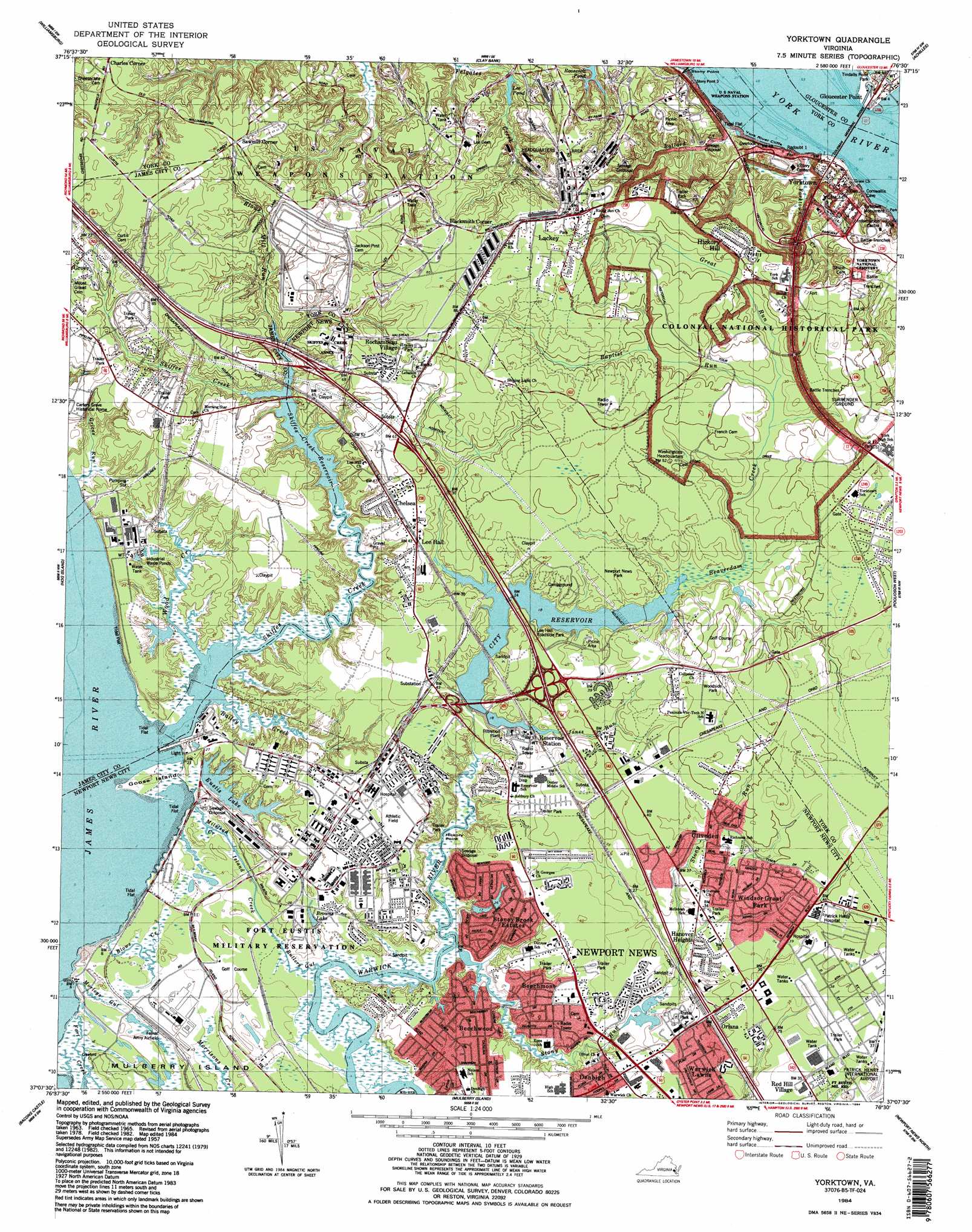
USGS Topo Quad 37076b5 - 1:24,000 scale
| Topo Map Name: | Yorktown |
| USGS Topo Quad ID: | 37076b5 |
| Print Size: | ca. 21 1/4" wide x 27" high |
| Southeast Coordinates: | 37.125° N latitude / 76.5° W longitude |
| Map Center Coordinates: | 37.1875° N latitude / 76.5625° W longitude |
| U.S. State: | VA |
| Filename: | o37076b5.jpg |
| Download Map JPG Image: | Yorktown topo map 1:24,000 scale |
| Map Type: | Topographic |
| Topo Series: | 7.5´ |
| Map Scale: | 1:24,000 |
| Source of Map Images: | United States Geological Survey (USGS) |
| Alternate Map Versions: |
Yorktown VA 1944 Download PDF Buy paper map Yorktown VA 1950, updated 1954 Download PDF Buy paper map Yorktown VA 1957, updated 1960 Download PDF Buy paper map Yorktown VA 1965, updated 1968 Download PDF Buy paper map Yorktown VA 1965, updated 1971 Download PDF Buy paper map Yorktown VA 1965, updated 1974 Download PDF Buy paper map Yorktown VA 1965, updated 1980 Download PDF Buy paper map Yorktown VA 1984, updated 1984 Download PDF Buy paper map Yorktown VA 1984, updated 1984 Download PDF Buy paper map Yorktown VA 1994, updated 1999 Download PDF Buy paper map Yorktown VA 2010 Download PDF Buy paper map Yorktown VA 2013 Download PDF Buy paper map Yorktown VA 2016 Download PDF Buy paper map |
1:24,000 Topo Quads surrounding Yorktown
Toano |
Gressitt |
Gloucester |
Ware Neck |
Mathews |
Norge |
Williamsburg |
Clay Bank |
Achilles |
New Point Comfort |
Surry |
Hog Island |
Yorktown |
Poquoson West |
Poquoson East |
Runnymede |
Bacons Castle |
Mulberry Island |
Newport News North |
Hampton |
Raynor |
Smithfield |
Benns Church |
Newport News South |
Norfolk North |
> Back to 37076a1 at 1:100,000 scale
> Back to 37076a1 at 1:250,000 scale
> Back to U.S. Topo Maps home
Yorktown topo map: Gazetteer
Yorktown: Airports
Mary Immaculate Hospital Heliport elevation 10m 32′Yorktown: Bays
Cornwallis Cove elevation 0m 0′Yorktown: Beaches
Yorktown Beach elevation 0m 0′Yorktown: Bridges
Coleman Memorial Bridge elevation 0m 0′Yorktown: Capes
Gloucester Point elevation 0m 0′Hickory Point elevation 0m 0′
Stony Point elevation 0m 0′
Yorktown: Cliffs
York River Cliffs elevation 8m 26′Yorktown: Crossings
Interchange 247 elevation 9m 29′Interchange 250 elevation 18m 59′
Yorktown: Dams
City Reservoir Dam elevation 5m 16′Eustis Dam elevation 3m 9′
Skiffs Creek Dam elevation 3m 9′
Yorktown: Guts
Butlers Gut elevation 2m 6′Fort Creek elevation 0m 0′
Island Creek elevation 0m 0′
Milstead Creek elevation 1m 3′
Morleys Gut elevation 1m 3′
Yorktown: Islands
Goose Island elevation 1m 3′Yorktown: Lakes
Browns Lake elevation 6m 19′Yorktown: Parks
Charles E Brown Park elevation 20m 65′Colonial National Historical Park elevation 12m 39′
Endview Plantation Historic Site elevation 18m 59′
Lee Hall Roadside Park elevation 7m 22′
Murphy Field elevation 10m 32′
Newport News Park elevation 12m 39′
Potters Field Park elevation 9m 29′
Tindalls Point Park elevation 6m 19′
Woodside Park elevation 17m 55′
Yorktown Monument elevation 19m 62′
Yorktown: Populated Places
Americana Park East Mobile Home Park elevation 12m 39′Beechmont elevation 6m 19′
Beechwood elevation 9m 29′
Blacksmith Corner elevation 26m 85′
Booth elevation 21m 68′
Bradmere elevation 11m 36′
Chelsea elevation 18m 59′
Cliveden elevation 12m 39′
Collards Mobile Home Park elevation 12m 39′
Country Village Mobile Home Park elevation 21m 68′
Denbigh elevation 10m 32′
Denbigh Mobile Home Park elevation 7m 22′
Edgemoor elevation 12m 39′
Hanover Heights elevation 9m 29′
Heritage Mobile Home Park elevation 18m 59′
Hickory Hill elevation 19m 62′
Lackey elevation 24m 78′
Lee Hall elevation 12m 39′
Merry Oaks elevation 9m 29′
Oriana elevation 9m 29′
Patricia Heights elevation 8m 26′
Pauls Trailer Park elevation 10m 32′
Poplar Hall Plantation elevation 18m 59′
Porter Mobile Home Park elevation 11m 36′
Red Hill Village elevation 10m 32′
Rochambeau Village elevation 23m 75′
Sawmill Corner elevation 25m 82′
Skiffes Creek Annex elevation 17m 55′
Stoney Brook Estates elevation 9m 29′
Torrey Pines Mobile Home Park elevation 11m 36′
Trailux Mobile Village elevation 7m 22′
Windsor Great Park elevation 12m 39′
Windy Hill Mobile Home Park elevation 18m 59′
Woods Run elevation 15m 49′
Yorktown elevation 2m 6′
Zooks Trailer Court elevation 21m 68′
Yorktown: Post Offices
Denbigh Annex Post Office elevation 9m 29′Fort Eustis Post Office elevation 10m 32′
Lackey Post Office elevation 24m 78′
Lee Hall Station Newport News Post Office elevation 12m 39′
Naval Weapons Station Post Office elevation 24m 78′
Patrick Henry Post Office elevation 10m 32′
Yorktown Post Office elevation 2m 6′
Yorktown: Reservoirs
City Reservoir elevation 6m 19′Eustis Lake elevation 3m 9′
Lee Pond elevation 5m 16′
Skiffes Creek Reservoir elevation 3m 9′
Skiffs Creek Reservoir elevation 2m 6′
Yorktown: Streams
Bailey Creek elevation 0m 0′Ballard Creek elevation 2m 6′
Baptist Run elevation 7m 22′
Beaverdam Creek elevation 5m 16′
Blows Creek elevation 0m 0′
Blows Mill Run elevation 3m 9′
Great Run elevation 7m 22′
Grices Run elevation 0m 0′
Jones Run elevation 6m 19′
Skiffes Creek elevation 0m 0′
Stony Run elevation 8m 26′
Wood Creek elevation 0m 0′
Yorktown Creek elevation 1m 3′
Yorktown: Summits
Pigeon Quarter elevation 21m 68′Yorktown digital topo map on disk
Buy this Yorktown topo map showing relief, roads, GPS coordinates and other geographical features, as a high-resolution digital map file on DVD:
Atlantic Coast (NY, NJ, PA, DE, MD, VA, NC)
Buy digital topo maps: Atlantic Coast (NY, NJ, PA, DE, MD, VA, NC)
 map DVD")