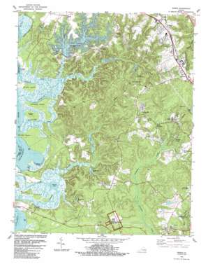
Norge Topo Map Virginia
To zoom in, hover over the map of Norge
USGS Topo Quad 37076c7 - 1:24,000 scale
| Topo Map Name: | Norge |
| USGS Topo Quad ID: | 37076c7 |
| Print Size: | ca. 21 1/4" wide x 27" high |
| Southeast Coordinates: | 37.25° N latitude / 76.75° W longitude |
| Map Center Coordinates: | 37.3125° N latitude / 76.8125° W longitude |
| U.S. State: | VA |
| Filename: | o37076c7.jpg |
| Download Map JPG Image: | Norge topo map 1:24,000 scale |
| Map Type: | Topographic |
| Topo Series: | 7.5´ |
| Map Scale: | 1:24,000 |
| Source of Map Images: | United States Geological Survey (USGS) |
| Alternate Map Versions: |
Norge VA 1952, updated 1958 Download PDF Buy paper map Norge VA 1953 Download PDF Buy paper map Norge VA 1965, updated 1967 Download PDF Buy paper map Norge VA 1965, updated 1973 Download PDF Buy paper map Norge VA 1965, updated 1980 Download PDF Buy paper map Norge VA 1978, updated 1983 Download PDF Buy paper map Norge VA 1984, updated 1984 Download PDF Buy paper map Norge VA 1984, updated 1989 Download PDF Buy paper map Norge VA 1984, updated 1989 Download PDF Buy paper map Norge VA 1994, updated 2000 Download PDF Buy paper map Norge VA 2010 Download PDF Buy paper map Norge VA 2013 Download PDF Buy paper map Norge VA 2016 Download PDF Buy paper map |
1:24,000 Topo Quads surrounding Norge
> Back to 37076a1 at 1:100,000 scale
> Back to 37076a1 at 1:250,000 scale
> Back to U.S. Topo Maps home
Norge topo map: Gazetteer
Norge: Bays
Bazzard Bay elevation 0m 0′Buzzard Bay elevation 0m 0′
Nayses Bay elevation 0m 0′
Norge: Capes
Bush Neck elevation 3m 9′Shields Point elevation 0m 0′
Norge: Dams
Camp Chickahominy Lake Dam elevation 24m 78′Cranstons Dam elevation 0m 0′
Jolly Dam elevation 4m 13′
Little Creek Dam elevation 18m 59′
Rennicks Pond Dam elevation 15m 49′
Warburton Pond Dam elevation 0m 0′
Norge: Guts
Shipyard Creek elevation 1m 3′Norge: Islands
Gordon Island elevation 6m 19′Simpson Island elevation 1m 3′
Wright Island elevation 1m 3′
Yarmouth Island elevation 3m 9′
Norge: Lakes
Pine Woods Pond elevation 6m 19′Norge: Parks
Green Springs National Historic Landmark District elevation 16m 52′Little Creek Reservoir Recreation Area elevation 26m 85′
Mid County Park elevation 27m 88′
Norge: Populated Places
Adams Hunt elevation 26m 85′Baron Woods elevation 22m 72′
Burton Woods elevation 25m 82′
Camelot elevation 32m 104′
Centerville elevation 31m 101′
Chestnut Hill elevation 9m 29′
Claybank Landing elevation 0m 0′
Deerwood Hills elevation 23m 75′
Farmville Estates elevation 31m 101′
Fieldcrest elevation 9m 29′
Five Forks elevation 25m 82′
Fords Colony elevation 20m 65′
Forest Glen elevation 32m 104′
Fox Ridge elevation 25m 82′
Greensprings Mobile Home Park elevation 23m 75′
Heath Trailer Park elevation 32m 104′
Heritage Landing elevation 9m 29′
Hunters Creek elevation 29m 95′
James Shire Settlement elevation 25m 82′
Kristiansand elevation 31m 101′
Lafayette Square elevation 16m 52′
Lake Toano Estates elevation 33m 108′
Lightfoot elevation 36m 118′
Longhill Gate elevation 22m 72′
Marstons Mobile Home Park elevation 27m 88′
Middle Plantation elevation 20m 65′
Mobile Estates elevation 31m 101′
Norge elevation 34m 111′
Norge Court elevation 33m 108′
Oakland elevation 25m 82′
Powhatan Crossing elevation 24m 78′
Powhatan of Williamsburg elevation 23m 75′
Powhatan Plantation elevation 23m 75′
Powhatan Secondary elevation 16m 52′
Seasons Trace elevation 25m 82′
Springhill elevation 22m 72′
Steeple Chase elevation 24m 78′
The Foxes elevation 23m 75′
The Links elevation 19m 62′
The Meadows elevation 22m 72′
Toano Trace elevation 34m 111′
Warren Mill elevation 27m 88′
Williamsburg West elevation 24m 78′
Windsor Forest elevation 31m 101′
Norge: Post Offices
Lightfoot Post Office elevation 37m 121′Norge Post Office elevation 33m 108′
Norge: Reservoirs
Camp Chickahominy Lake elevation 24m 78′Cranstons Pond elevation 0m 0′
Deer Lake elevation 9m 29′
Eastern State Hospital Reservoir elevation 7m 22′
Jolly Pond elevation 4m 13′
Little Creek Reservoir elevation 18m 59′
Rennicks Pond elevation 15m 49′
Scotts Pond elevation 16m 52′
Warburton Pond elevation 0m 0′
Norge: Streams
Blackstump Creek elevation 0m 0′Chisel Run elevation 7m 22′
Colby Swamp elevation 4m 13′
Hog Neck Creek elevation 0m 0′
Little Creek elevation 3m 9′
Long Hill Swamp elevation 6m 19′
Pine Woods Creek elevation 0m 0′
Uncles Neck Creek elevation 3m 9′
Yarmouth Creek elevation 0m 0′
Norge digital topo map on disk
Buy this Norge topo map showing relief, roads, GPS coordinates and other geographical features, as a high-resolution digital map file on DVD:
Atlantic Coast (NY, NJ, PA, DE, MD, VA, NC)
Buy digital topo maps: Atlantic Coast (NY, NJ, PA, DE, MD, VA, NC)


