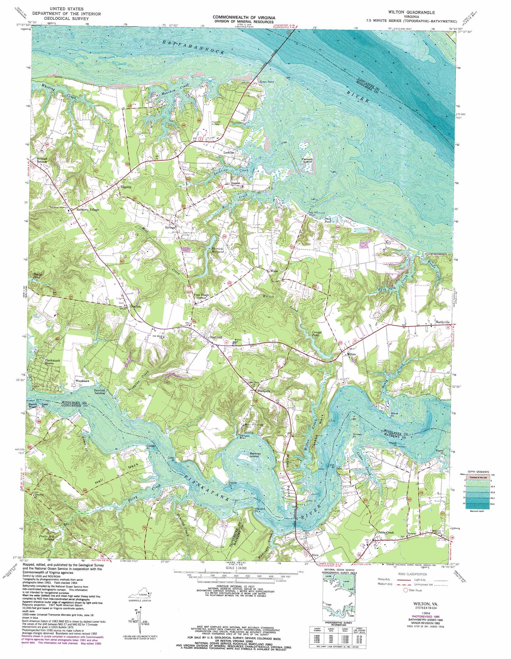
Wilton Topo Map Virginia
To zoom in, hover over the map of Wilton
USGS Topo Quad 37076e4 - 1:24,000 scale
| Topo Map Name: | Wilton |
| USGS Topo Quad ID: | 37076e4 |
| Print Size: | ca. 21 1/4" wide x 27" high |
| Southeast Coordinates: | 37.5° N latitude / 76.375° W longitude |
| Map Center Coordinates: | 37.5625° N latitude / 76.4375° W longitude |
| U.S. State: | VA |
| Filename: | o37076e4.jpg |
| Download Map JPG Image: | Wilton topo map 1:24,000 scale |
| Map Type: | Topographic |
| Topo Series: | 7.5´ |
| Map Scale: | 1:24,000 |
| Source of Map Images: | United States Geological Survey (USGS) |
| Alternate Map Versions: |
Wilton VA 1949 Download PDF Buy paper map Wilton VA 1964, updated 1966 Download PDF Buy paper map Wilton VA 1964, updated 1974 Download PDF Buy paper map Wilton VA 1964, updated 1986 Download PDF Buy paper map Wilton VA 1964, updated 1993 Download PDF Buy paper map Wilton VA 2010 Download PDF Buy paper map Wilton VA 2013 Download PDF Buy paper map Wilton VA 2016 Download PDF Buy paper map |
1:24,000 Topo Quads surrounding Wilton
Morattico |
Lively |
Lancaster |
Reedville |
East of Reedville |
Church View |
Urbanna |
Irvington |
Fleets Bay |
East of Fleets Bay |
Shacklefords |
Saluda |
Wilton |
Deltaville |
East Of Deltaville |
Gressitt |
Gloucester |
Ware Neck |
Mathews |
Bethel Beach |
Williamsburg |
Clay Bank |
Achilles |
New Point Comfort |
East Of New Point Comfort |
> Back to 37076e1 at 1:100,000 scale
> Back to 37076a1 at 1:250,000 scale
> Back to U.S. Topo Maps home
Wilton topo map: Gazetteer
Wilton: Airports
Hummel Field elevation 9m 29′Wilton: Bridges
Norris Bridge elevation 0m 0′Twigg Bridge elevation 0m 0′
Wilton: Capes
Cooper Point elevation 0m 0′Creek Point elevation 0m 0′
Deep Point elevation 1m 3′
Doctor Point elevation 7m 22′
Ginney Point elevation 0m 0′
Glebe Neck elevation 11m 36′
Greys Point elevation 0m 0′
Hell Neck elevation 10m 32′
Holland Point elevation 4m 13′
Horse Point elevation 0m 0′
Iron Point elevation 4m 13′
Pond Point elevation 3m 9′
Roane Point elevation 0m 0′
Wilton Point elevation 5m 16′
Wilton: Crossings
Grey Point-White Stone Ferry (historical) elevation 0m 0′Shipleys Ferry (historical) elevation 0m 0′
Wilton: Dams
Barricks Dam elevation 3m 9′Conrads Dam elevation 3m 9′
Wilton: Islands
Berkley Island elevation 1m 3′Parrott Island elevation 2m 6′
Wilton: Lakes
Duck Pond elevation 2m 6′Wilton: Populated Places
Barretts elevation 13m 42′Bushy elevation 15m 49′
Cheaden (historical) elevation 25m 82′
Cobbs Creek elevation 10m 32′
Dixie elevation 12m 39′
Fairfield Landing elevation 0m 0′
Free Shade Corner elevation 23m 75′
Grafton elevation 28m 91′
Harmony Village elevation 28m 91′
Hartfield elevation 24m 78′
Locklies elevation 9m 29′
Nohead Bottom elevation 24m 78′
Piankatank Shores elevation 5m 16′
Regent elevation 10m 32′
Stampers elevation 22m 72′
Syringa elevation 17m 55′
Topping elevation 13m 42′
Wake elevation 17m 55′
Wilton elevation 12m 39′
Woodstock elevation 4m 13′
Wilton: Reservoirs
Barricks Millpond elevation 3m 9′Barricks Pond elevation 5m 16′
Conrad Pond elevation 3m 9′
Conrads Pond elevation 7m 22′
Wilton: Streams
Bush Park Creek elevation 0m 0′Cobbs Creek elevation 0m 0′
Dancing Creek elevation 0m 0′
Ferry Creek elevation 0m 0′
French Creek elevation 3m 9′
Healy Creek elevation 0m 0′
Locklies Creek elevation 0m 0′
Meachim Creek elevation 0m 0′
Mill Creek elevation 0m 0′
Scoggins Creek elevation 1m 3′
Wadinger Creek elevation 1m 3′
Wilton Creek elevation 0m 0′
Woods Creek elevation 11m 36′
Wilton: Swamps
Pratts Mill Swamp elevation 4m 13′Wilton digital topo map on disk
Buy this Wilton topo map showing relief, roads, GPS coordinates and other geographical features, as a high-resolution digital map file on DVD:
Atlantic Coast (NY, NJ, PA, DE, MD, VA, NC)
Buy digital topo maps: Atlantic Coast (NY, NJ, PA, DE, MD, VA, NC)
 map DVD")