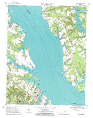
Urbanna Topo Map Virginia
To zoom in, hover over the map of Urbanna
USGS Topo Quad 37076f5 - 1:24,000 scale
| Topo Map Name: | Urbanna |
| USGS Topo Quad ID: | 37076f5 |
| Print Size: | ca. 21 1/4" wide x 27" high |
| Southeast Coordinates: | 37.625° N latitude / 76.5° W longitude |
| Map Center Coordinates: | 37.6875° N latitude / 76.5625° W longitude |
| U.S. State: | VA |
| Filename: | o37076f5.jpg |
| Download Map JPG Image: | Urbanna topo map 1:24,000 scale |
| Map Type: | Topographic |
| Topo Series: | 7.5´ |
| Map Scale: | 1:24,000 |
| Source of Map Images: | United States Geological Survey (USGS) |
| Alternate Map Versions: |
Urbanna VA 1946, updated 1966 Download PDF Buy paper map Urbanna VA 1949 Download PDF Buy paper map Urbanna VA 1968, updated 1971 Download PDF Buy paper map Urbanna VA 1968, updated 1971 Download PDF Buy paper map Urbanna VA 2010 Download PDF Buy paper map Urbanna VA 2013 Download PDF Buy paper map Urbanna VA 2016 Download PDF Buy paper map |
1:24,000 Topo Quads surrounding Urbanna
> Back to 37076e1 at 1:100,000 scale
> Back to 37076a1 at 1:250,000 scale
> Back to U.S. Topo Maps home
Urbanna topo map: Gazetteer
Urbanna: Airports
Rosegill Farm Airstrip elevation 10m 32′Urbanna: Bars
Beach Creek Spit elevation 3m 9′Towles Point Bar elevation 0m 0′
Weeks Flats elevation 0m 0′
Urbanna: Basins
Rogues Hole elevation -1m -4′Urbanna: Bays
The Punchbowl elevation 0m 0′Urbanna: Capes
Bailey Point elevation 0m 0′Balls Point elevation 0m 0′
Cedar Point elevation 0m 0′
Corrotoman Neck elevation 10m 32′
Drum Point elevation 2m 6′
Goose Point elevation 1m 3′
Lawsons Island elevation 1m 3′
Long Point elevation 3m 9′
Old Orchard Point elevation 1m 3′
Old Womans Point elevation 1m 3′
Punchbowl Point elevation 1m 3′
Rocky Neck elevation 6m 19′
Rogue Point elevation 3m 9′
Ross Point elevation 0m 0′
Sheltons Point elevation 3m 9′
Smoky Point elevation 0m 0′
Stove Point elevation 0m 0′
Towles Point elevation 1m 3′
Turtle Point elevation 0m 0′
Weeks Point elevation 0m 0′
Urbanna: Crossings
Chewnings Point Ferry (historical) elevation 0m 0′Urbanna: Dams
Corbin Hall Farm Dam elevation 3m 9′Lower Rosegill Lake Dam elevation 1m 3′
Rosegill Upper Dam elevation 3m 9′
Town Bridge Pond Dam elevation 6m 19′
Urbanna: Parks
Urbanna Historic District elevation 8m 26′Urbanna: Populated Places
Bertrand elevation 6m 19′Greenvale (historical) elevation 6m 19′
Mollusk elevation 18m 59′
Monaskon elevation 7m 22′
Ottoman elevation 15m 49′
Pine Tree elevation 8m 26′
Remlik elevation 15m 49′
Senora elevation 9m 29′
Urbanna elevation 6m 19′
Water View elevation 7m 22′
Urbanna: Post Offices
Mollusk Post Office elevation 12m 39′Urbanna Post Office elevation 10m 32′
Urbanna: Reservoirs
Corbin Hall Farm Pond elevation 3m 9′Glebe Pond elevation 24m 78′
Rosegil Lake elevation 1m 3′
Rosegill Lake elevation 1m 3′
Town Bridge Pond elevation 6m 19′
Urbanna: Streams
Beach Creek elevation 2m 6′Belmont Creek elevation 0m 0′
Bulls Creek elevation 7m 22′
Davis Creek elevation 1m 3′
Ewells Prong elevation 0m 0′
Glebe Swamp elevation -1m -4′
Greenvale Creek elevation 0m 0′
Harry George Creek elevation 0m 0′
Lagrange Creek elevation 0m 0′
Little Branch elevation 1m 3′
Midway Creek elevation 3m 9′
Millenbeck Prong elevation 0m 0′
Mud Creek elevation 0m 0′
Parrotts Creek elevation 0m 0′
Paynes Creek elevation 1m 3′
Perkins Creek elevation 0m 0′
Robinson Creek elevation 0m 0′
Senior Creek elevation 5m 16′
South Branch Lagrange Creek elevation 0m 0′
Town Bridge Swamp elevation 10m 32′
Urbanna Creek elevation 0m 0′
Weeks Creek elevation 0m 0′
Wyatt Creek elevation 5m 16′
Urbanna digital topo map on disk
Buy this Urbanna topo map showing relief, roads, GPS coordinates and other geographical features, as a high-resolution digital map file on DVD:
Atlantic Coast (NY, NJ, PA, DE, MD, VA, NC)
Buy digital topo maps: Atlantic Coast (NY, NJ, PA, DE, MD, VA, NC)


