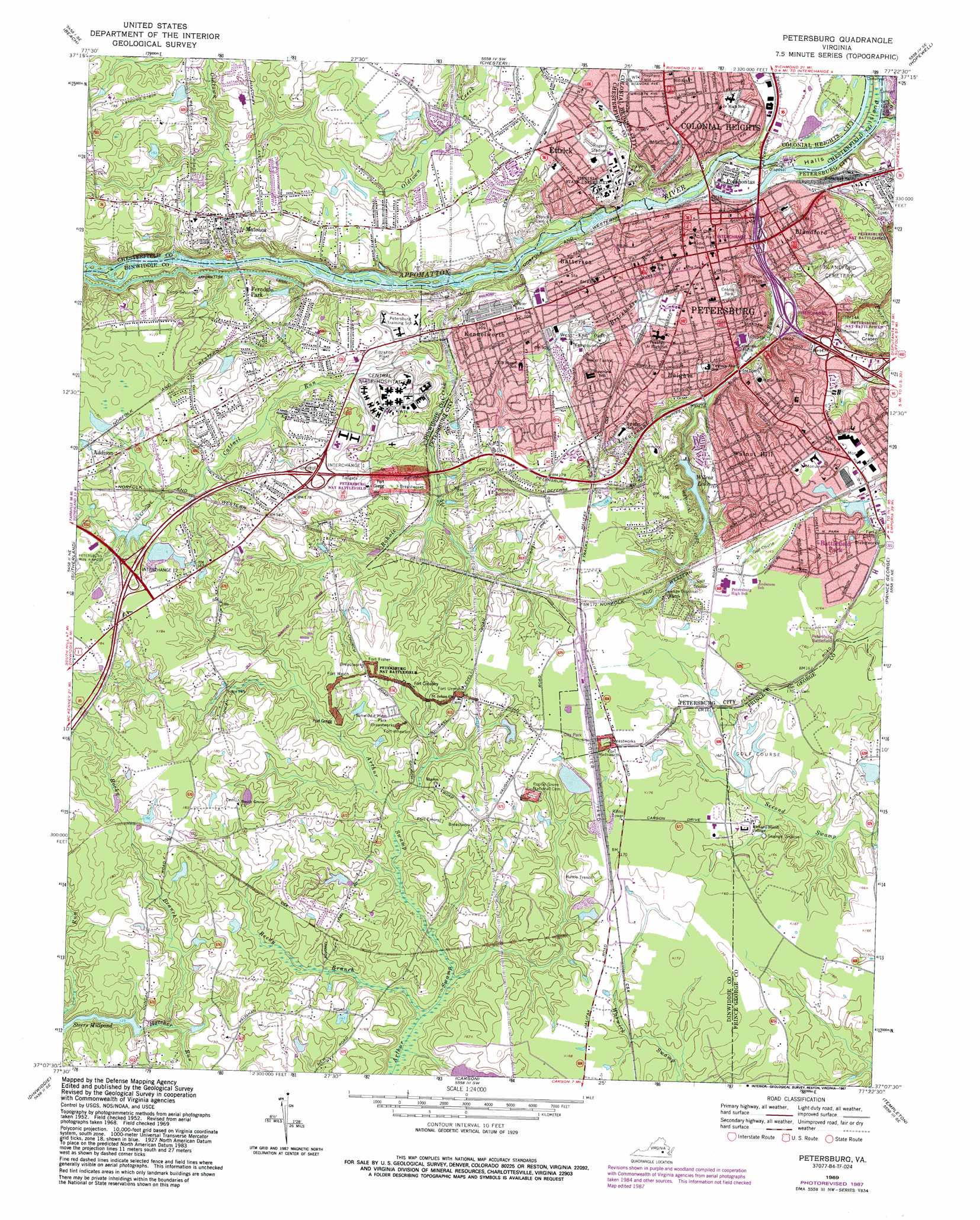
Petersburg Topo Map Virginia
To zoom in, hover over the map of Petersburg
USGS Topo Quad 37077b4 - 1:24,000 scale
| Topo Map Name: | Petersburg |
| USGS Topo Quad ID: | 37077b4 |
| Print Size: | ca. 21 1/4" wide x 27" high |
| Southeast Coordinates: | 37.125° N latitude / 77.375° W longitude |
| Map Center Coordinates: | 37.1875° N latitude / 77.4375° W longitude |
| U.S. State: | VA |
| Filename: | o37077b4.jpg |
| Download Map JPG Image: | Petersburg topo map 1:24,000 scale |
| Map Type: | Topographic |
| Topo Series: | 7.5´ |
| Map Scale: | 1:24,000 |
| Source of Map Images: | United States Geological Survey (USGS) |
| Alternate Map Versions: |
Petersburg VA 1952, updated 1959 Download PDF Buy paper map Petersburg VA 1969, updated 1971 Download PDF Buy paper map Petersburg VA 1969, updated 1982 Download PDF Buy paper map Petersburg VA 1969, updated 1987 Download PDF Buy paper map Petersburg VA 1974, updated 1977 Download PDF Buy paper map Petersburg VA 1994, updated 1996 Download PDF Buy paper map Petersburg VA 2010 Download PDF Buy paper map Petersburg VA 2013 Download PDF Buy paper map Petersburg VA 2016 Download PDF Buy paper map |
1:24,000 Topo Quads surrounding Petersburg
Hallsboro |
Chesterfield |
Drewrys Bluff |
Dutch Gap |
Roxbury |
Winterpock |
Beach |
Chester |
Hopewell |
Westover |
Church Road |
Sutherland |
Petersburg |
Prince George |
Disputanta North |
De Witt |
Dinwiddie |
Carson |
Templeton |
Disputanta South |
Mckenney |
Cherry Hill |
Stony Creek |
Sussex |
Littleton |
> Back to 37077a1 at 1:100,000 scale
> Back to 37076a1 at 1:250,000 scale
> Back to U.S. Topo Maps home
Petersburg topo map: Gazetteer
Petersburg: Airports
Mazza Airport elevation 52m 170′Srmc Heliport elevation 39m 127′
Petersburg: Bridges
Butterworth Bridge (historical) elevation 45m 147′Petersburg: Craters
The Crater elevation 36m 118′Petersburg: Crossings
Field Crossing elevation 55m 180′Haskin Crossing elevation 51m 167′
Interchange 49 elevation 35m 114′
Interchange 50 elevation 47m 154′
Interchange 51 elevation 23m 75′
Interchange 52 elevation 13m 42′
Interchange 61 elevation 55m 180′
Interchange 63 elevation 51m 167′
Interchange 65 elevation 51m 167′
Petersburg: Dams
Bragan Dam elevation 45m 147′Cernys Dam elevation 45m 147′
Claytons Dam elevation 53m 173′
Musgrove Dam elevation 48m 157′
Steers Dam elevation 36m 118′
Wilcox Dam elevation 30m 98′
Petersburg: Parks
Appomattox Riverside Park elevation 24m 78′Central Park elevation 21m 68′
Centre Hill Historic District elevation 22m 72′
Colbert Baseball Field elevation 23m 75′
Ettrick Park elevation 32m 104′
Folly Castle Historic District elevation 22m 72′
Jefferson Street Park elevation 27m 88′
Lee Memorial Park elevation 50m 164′
McKenzie Street Park elevation 22m 72′
Pamplin Historical Park elevation 55m 180′
Petersburg Courthouse Historic District elevation 19m 62′
Petersburg Old Town Historic District elevation 10m 32′
Poplar Lawn Historic District elevation 21m 68′
Rogers Stadium elevation 23m 75′
Shepherd Field elevation 26m 85′
West End Park elevation 28m 91′
Petersburg: Populated Places
Ashley elevation 45m 147′Battersea elevation 26m 85′
Battlefield Park elevation 46m 150′
Beechnut Acres elevation 45m 147′
Blandford elevation 22m 72′
Bollinger Estates elevation 31m 101′
Burnside elevation 34m 111′
Camelot elevation 49m 160′
College Park elevation 31m 101′
Colonial Heights elevation 29m 95′
Dinwiddie Gardens elevation 52m 170′
Dunedin elevation 45m 147′
Edge Hill Park elevation 47m 154′
Ettrick elevation 32m 104′
Ferndale Gardens elevation 38m 124′
Ferndale Park elevation 41m 134′
Grant Village elevation 46m 150′
Greenwood Farms elevation 46m 150′
Heights elevation 45m 147′
Hickory Hill Estates elevation 35m 114′
Holly Acres elevation 31m 101′
Kennelworth elevation 34m 111′
Maitland Village elevation 51m 167′
Mansfield elevation 52m 170′
Matoaca elevation 43m 141′
Matoaca Manor elevation 43m 141′
Noweta Gardens elevation 36m 118′
Oak Forest elevation 47m 154′
Oakhill elevation 52m 170′
Parkview elevation 54m 177′
Pembroke elevation 33m 108′
Petersburg elevation 22m 72′
Pocahontas elevation 7m 22′
Rabbit Run elevation 42m 137′
Ramblewood elevation 53m 173′
River Road Estates elevation 29m 95′
River Road Terrace elevation 31m 101′
River View Park elevation 41m 134′
Robertson Place elevation 39m 127′
Rohoic Farms elevation 52m 170′
Southern Pines elevation 46m 150′
Sysonby Ridge elevation 51m 167′
Trojan Woods elevation 32m 104′
Virginia Hills elevation 46m 150′
Walnut Hill elevation 46m 150′
Walnut Hill Gardens elevation 46m 150′
Warrington Heights elevation 52m 170′
West Chesterfield Heights elevation 27m 88′
West Petersburg elevation 47m 154′
Westbourne elevation 52m 170′
Westchester elevation 46m 150′
Western Hills elevation 46m 150′
Westover Park elevation 44m 144′
Woodmere elevation 45m 147′
Petersburg: Post Offices
Ettrick Post Office elevation 28m 91′Petersburg Post Office elevation 21m 68′
Walnut Hill Station Petersburg Post Office elevation 45m 147′
Western Station Petersburg Post Office elevation 27m 88′
Petersburg: Reservoirs
Cernys Pond elevation 45m 147′Claytons Pond elevation 53m 173′
Steers Millpond elevation 36m 118′
Wilcox Lake elevation 30m 98′
Petersburg: Streams
Brickhouse Run elevation 11m 36′Cattail Run elevation 22m 72′
Fleets Branch elevation 3m 9′
Harrison Creek elevation 3m 9′
Lieutenant Run elevation 2m 6′
Poor Creek elevation 0m 0′
Reedy Branch elevation 31m 101′
Rocky Branch elevation 35m 114′
Rohoic Creek elevation 17m 55′
Petersburg digital topo map on disk
Buy this Petersburg topo map showing relief, roads, GPS coordinates and other geographical features, as a high-resolution digital map file on DVD:
Atlantic Coast (NY, NJ, PA, DE, MD, VA, NC)
Buy digital topo maps: Atlantic Coast (NY, NJ, PA, DE, MD, VA, NC)
 map DVD")