Dutch Gap Topo Map Virginia
To zoom in, hover over the map of Dutch Gap
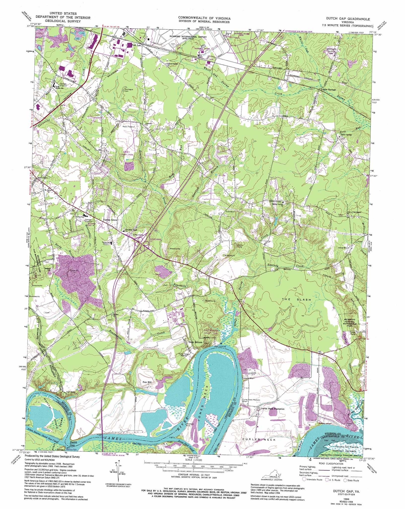
USGS Topo Quad 37077d3 - 1:24,000 scale
| Topo Map Name: | Dutch Gap |
| USGS Topo Quad ID: | 37077d3 |
| Print Size: | ca. 21 1/4" wide x 27" high |
| Southeast Coordinates: | 37.375° N latitude / 77.25° W longitude |
| Map Center Coordinates: | 37.4375° N latitude / 77.3125° W longitude |
| U.S. State: | VA |
| Filename: | o37077d3.jpg |
| Download Map JPG Image: | Dutch Gap topo map 1:24,000 scale |
| Map Type: | Topographic |
| Topo Series: | 7.5´ |
| Map Scale: | 1:24,000 |
| Source of Map Images: | United States Geological Survey (USGS) |
| Alternate Map Versions: |
Dutch Gap VA 1938 Download PDF Buy paper map Dutch Gap VA 1952, updated 1959 Download PDF Buy paper map Dutch Gap VA 1969, updated 1971 Download PDF Buy paper map Dutch Gap VA 1969, updated 1982 Download PDF Buy paper map Dutch Gap VA 1969, updated 1986 Download PDF Buy paper map Dutch Gap VA 1969, updated 1994 Download PDF Buy paper map Dutch Gap VA 2010 Download PDF Buy paper map Dutch Gap VA 2013 Download PDF Buy paper map Dutch Gap VA 2016 Download PDF Buy paper map |
1:24,000 Topo Quads surrounding Dutch Gap
Glen Allen |
Yellow Tavern |
Studley |
Manquin |
King William |
Bon Air |
Richmond |
Seven Pines |
Quinton |
Tunstall |
Chesterfield |
Drewrys Bluff |
Dutch Gap |
Roxbury |
Providence Forge |
Beach |
Chester |
Hopewell |
Westover |
Charles City |
Sutherland |
Petersburg |
Prince George |
Disputanta North |
Savedge |
> Back to 37077a1 at 1:100,000 scale
> Back to 37076a1 at 1:250,000 scale
> Back to U.S. Topo Maps home
Dutch Gap topo map: Gazetteer
Dutch Gap: Bays
Richmond Yacht Basin elevation 5m 16′Dutch Gap: Bends
Jones Neck Cutoff elevation 2m 6′Dutch Gap: Bridges
Varina - Enon Bridge elevation 0m 0′Dutch Gap: Capes
Jones Neck elevation 0m 0′Point Bremo elevation 1m 3′
Woodson Rock elevation 1m 3′
Dutch Gap: Channels
Aiken Swamp-Dutch Gap Cutoff elevation 1m 3′Dutch Gap: Dams
Griggs Dam elevation 3m 9′Dutch Gap: Flats
The Slash elevation 15m 49′Dutch Gap: Gaps
Dutch Gap elevation 1m 3′Dutch Gap: Islands
Hatcher Island elevation 3m 9′Dutch Gap: Parks
Deep Bottom Park elevation 15m 49′Dorey Park elevation 42m 137′
Four Mile Creek Park elevation 18m 59′
Henricus Park elevation 3m 9′
Richmond National Battlefield Park elevation 37m 121′
Dutch Gap: Populated Places
Cotman (historical) elevation 10m 32′Darbytown Estates elevation 44m 144′
Deep Bottom elevation 2m 6′
Fair Hill elevation 12m 39′
Fort Lee elevation 50m 164′
Henricopolis (historical) elevation 14m 45′
Turner Woods elevation 44m 144′
Varina elevation 42m 137′
Varina Farm elevation 9m 29′
Varina Gardens elevation 45m 147′
Varina Grove elevation 44m 144′
Varina Meadows elevation 45m 147′
Varina Place elevation 45m 147′
Whitlock Estates elevation 44m 144′
Williamson Farms elevation 45m 147′
Yahley Mills Estates elevation 46m 150′
Dutch Gap: Reservoirs
Griggs Pond elevation 1m 3′Griggs Pond elevation 3m 9′
Valley Mill Pond elevation 24m 78′
Dutch Gap: Springs
Camp Holly Springs elevation 22m 72′Dutch Gap: Streams
Bailey Creek elevation 5m 16′Crewes Channel elevation 1m 3′
Deep Run elevation 28m 91′
Deerlick Branch elevation 19m 62′
Fourmile Creek elevation 5m 16′
Reedy Branch elevation 33m 108′
Ross Run elevation 22m 72′
Roundabout Creek elevation 0m 0′
Sweeney Creek elevation 5m 16′
White Oak Swamp Creek elevation 33m 108′
Dutch Gap: Swamps
Aiken Swamp elevation 3m 9′Dutch Gap digital topo map on disk
Buy this Dutch Gap topo map showing relief, roads, GPS coordinates and other geographical features, as a high-resolution digital map file on DVD:
Atlantic Coast (NY, NJ, PA, DE, MD, VA, NC)
Buy digital topo maps: Atlantic Coast (NY, NJ, PA, DE, MD, VA, NC)
 map DVD")