Richmond Topo Map Virginia
To zoom in, hover over the map of Richmond
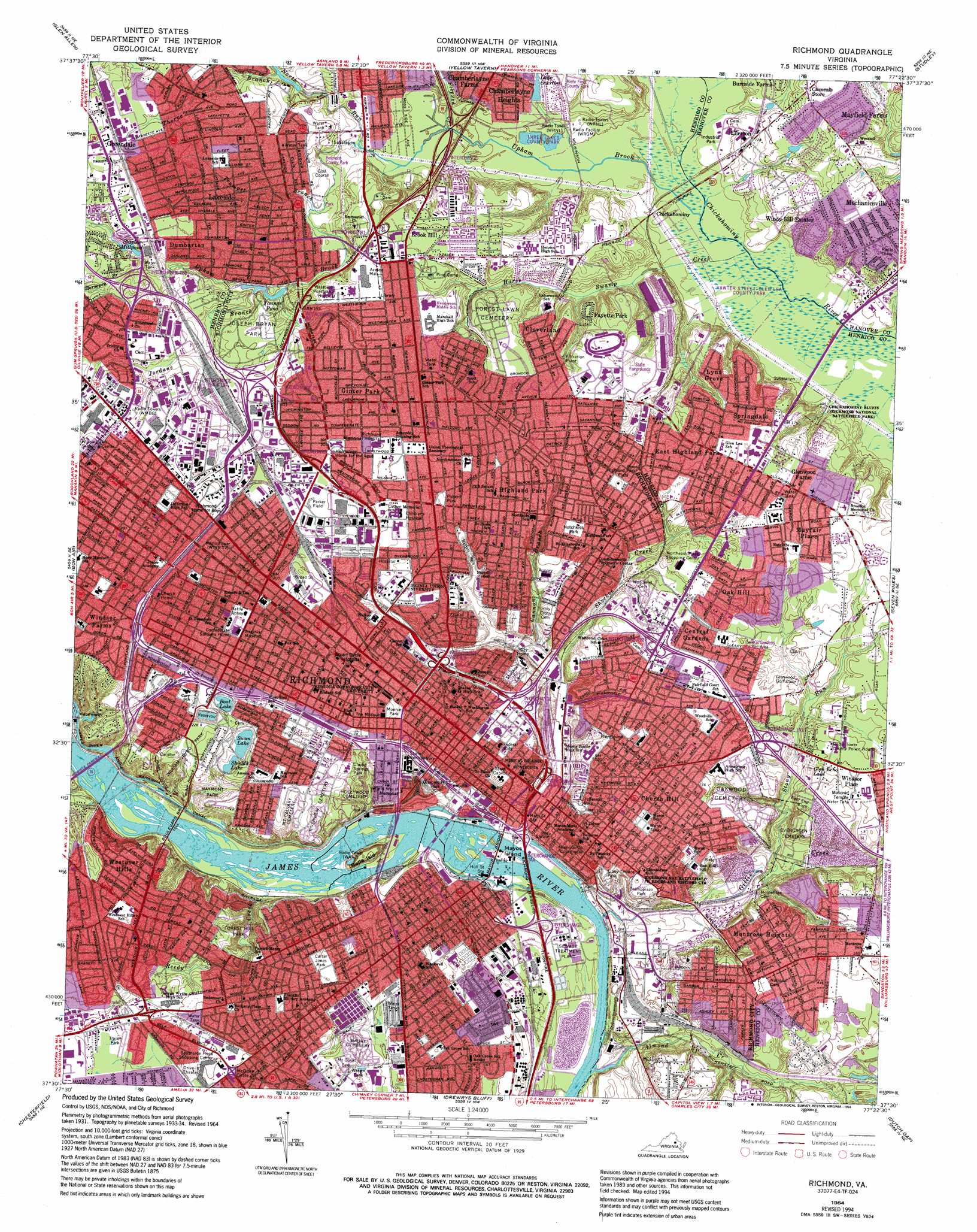
USGS Topo Quad 37077e4 - 1:24,000 scale
| Topo Map Name: | Richmond |
| USGS Topo Quad ID: | 37077e4 |
| Print Size: | ca. 21 1/4" wide x 27" high |
| Southeast Coordinates: | 37.5° N latitude / 77.375° W longitude |
| Map Center Coordinates: | 37.5625° N latitude / 77.4375° W longitude |
| U.S. State: | VA |
| Filename: | o37077e4.jpg |
| Download Map JPG Image: | Richmond topo map 1:24,000 scale |
| Map Type: | Topographic |
| Topo Series: | 7.5´ |
| Map Scale: | 1:24,000 |
| Source of Map Images: | United States Geological Survey (USGS) |
| Alternate Map Versions: |
Richmond VA 1934 Download PDF Buy paper map Richmond VA 1934, updated 1954 Download PDF Buy paper map Richmond VA 1956, updated 1959 Download PDF Buy paper map Richmond VA 1964, updated 1966 Download PDF Buy paper map Richmond VA 1964, updated 1969 Download PDF Buy paper map Richmond VA 1964, updated 1976 Download PDF Buy paper map Richmond VA 1964, updated 1981 Download PDF Buy paper map Richmond VA 1964, updated 1987 Download PDF Buy paper map Richmond VA 1964, updated 1991 Download PDF Buy paper map Richmond VA 1964, updated 1994 Download PDF Buy paper map Richmond VA 1964, updated 1994 Download PDF Buy paper map Richmond VA 1974, updated 1977 Download PDF Buy paper map Richmond VA 2010 Download PDF Buy paper map Richmond VA 2013 Download PDF Buy paper map Richmond VA 2016 Download PDF Buy paper map |
1:24,000 Topo Quads surrounding Richmond
Montpelier |
Hanover Academy |
Ashland |
Hanover |
Beulahville |
Hylas |
Glen Allen |
Yellow Tavern |
Studley |
Manquin |
Midlothian |
Bon Air |
Richmond |
Seven Pines |
Quinton |
Hallsboro |
Chesterfield |
Drewrys Bluff |
Dutch Gap |
Roxbury |
Winterpock |
Beach |
Chester |
Hopewell |
Westover |
> Back to 37077e1 at 1:100,000 scale
> Back to 37076a1 at 1:250,000 scale
> Back to U.S. Topo Maps home
Richmond topo map: Gazetteer
Richmond: Airports
Browns Island Heliport elevation 9m 29′MCV Heliport elevation 43m 141′
Medical College of Virginia Heliport elevation 18m 59′
Richmond: Bridges
Boulevard Bridge elevation 18m 59′Ford Bridge (historical) elevation 25m 82′
J E B Stuart Bridge elevation 26m 85′
Manchester Bridge elevation 6m 19′
Martin Luther King Junior Memorial Bridge elevation 13m 42′
Mayos Bridge elevation 11m 36′
Robert E Lee Bridge elevation 14m 45′
Stonewall Jackson Bridge elevation 22m 72′
Richmond: Canals
Richmond City Canal elevation 0m 0′Richmond: Crossings
Interchange 185 elevation 57m 187′Interchange 186 elevation 61m 200′
Interchange 187 elevation 62m 203′
Interchange 190 elevation 45m 147′
Interchange 192 elevation 49m 160′
Interchange 193 elevation 45m 147′
Interchange 73 elevation 12m 39′
Interchange 74A elevation 6m 19′
Interchange 74B elevation 16m 52′
Interchange 74C elevation 18m 59′
Interchange 75 elevation 43m 141′
Interchange 76 elevation 42m 137′
Interchange 78 elevation 66m 216′
Interchange 80 elevation 54m 177′
Interchange 81 elevation 60m 196′
Interchange 82 elevation 33m 108′
Richmond: Dams
Byrd Park Canal Dam elevation 30m 98′Hollywood Power Plant Dam elevation 15m 49′
Three Chopt Estate Dam elevation 27m 88′
Upper Sheilds Lake Dam elevation 55m 180′
Vepco Flash Board Dam elevation 9m 29′
Youngs Pond Dam elevation 42m 137′
Richmond: Islands
Belle Isle elevation 31m 101′Browns Island elevation 9m 29′
Mayos Island elevation 8m 26′
Richmond: Parks
Abner Clay Park elevation 50m 164′Arthur Ashe Junior Athletic Center elevation 62m 203′
Battery Park elevation 40m 131′
Belmont Park elevation 45m 147′
Bojangles Statue elevation 50m 164′
Boulevard Historic District elevation 67m 219′
Brown Island Park elevation 9m 29′
Byron Highland Park Plaza elevation 57m 187′
Capitol Square elevation 46m 150′
Carter Jones Park elevation 47m 154′
Chickahominy Bluffs elevation 30m 98′
Chimborazo Park elevation 47m 154′
Clarke Springs Park elevation 48m 157′
Commodore Matthew Fontaine Maury Monument elevation 63m 206′
Commonwealth Club Historic District elevation 50m 164′
Confederate Soldiers and Sailors Monument elevation 42m 137′
English Village Historic District elevation 67m 219′
Fan Area Historic District elevation 63m 206′
Forest Hill Park elevation 39m 127′
General J E B Stuart Statue elevation 62m 203′
George Washington Statue elevation 48m 157′
Gimbles Hill Park elevation 39m 127′
Ginter Park Historic District elevation 61m 200′
Great Shiplock Park elevation 4m 13′
Highland Plaza elevation 57m 187′
Holly Street Park elevation 45m 147′
Hotchkiss Park elevation 50m 164′
Hovey Field elevation 52m 170′
Jackson Ward Historic District elevation 51m 167′
James River and Kanawha Canal Historic District elevation 33m 108′
Jefferson Davis Monument elevation 65m 213′
Jefferson Park elevation 46m 150′
Joseph Byran Park elevation 59m 193′
Kanawha Plaza elevation 24m 78′
Kiehr Field elevation 51m 167′
Libby Terrace Park elevation 47m 154′
Maggie L Walker National Historic Site elevation 50m 164′
Maymont Park elevation 58m 190′
Monroe Park elevation 57m 187′
Monroe Park Historic District elevation 54m 177′
Monument Avenue Historic District elevation 62m 203′
Oregon Hill Historic District elevation 51m 167′
Parker Field elevation 61m 200′
Parker Field elevation 32m 104′
Parker Field Annex elevation 63m 206′
Patrick Henry Park elevation 47m 154′
Poe Shrine elevation 14m 45′
Pollard Park elevation 53m 173′
Powhatan Playground elevation 41m 134′
Richmond City Fairgrounds (historical) elevation 57m 187′
Robert E Lee Statue elevation 64m 209′
Saint Johns Church Historic District elevation 41m 134′
Shockoe Slip Historic District elevation 9m 29′
Stonewall Jackson Statue elevation 62m 203′
Taylors Hill Park elevation 31m 101′
Three Lakes Park elevation 30m 98′
Twentynine Hundred Block Grove Avenue Historic District elevation 67m 219′
Two Hundred Block West Franklin Historic District elevation 54m 177′
University Stadium elevation 66m 216′
Vawter Street Park elevation 26m 85′
Washington Square Park elevation 25m 82′
West Franklin Street Historic District elevation 58m 190′
William Byrd Park elevation 63m 206′
World War II Memorial elevation 43m 141′
Richmond: Populated Places
Acca elevation 63m 206′Brook Hill elevation 61m 200′
Central Gardens elevation 51m 167′
Chestnut Hill elevation 47m 154′
Chickahominy elevation 29m 95′
Church Hill elevation 34m 111′
Church Hill elevation 51m 167′
Cloverland elevation 59m 193′
Dumbarton elevation 61m 200′
East Highland Park elevation 61m 200′
Ellerson elevation 38m 124′
Fayette Park elevation 54m 177′
Ginter Park elevation 60m 196′
Glenwood Farms elevation 58m 190′
Greendale elevation 63m 206′
Highland Park elevation 51m 167′
Lakeside elevation 54m 177′
Lower Rocketts elevation 39m 127′
Lynn Grove elevation 55m 180′
Manchester elevation 30m 98′
Mayfair Place elevation 59m 193′
Mayfield Farms elevation 59m 193′
Mobile Towne Mobile Home Park elevation 67m 219′
Montrose elevation 49m 160′
Montrose Heights elevation 48m 157′
Oak Hill elevation 51m 167′
Richmond elevation 64m 209′
Rocketts elevation 49m 160′
South Richmond elevation 20m 65′
Springdale elevation 58m 190′
Washington Park elevation 60m 196′
Westover Hills elevation 60m 196′
Windsor Farms elevation 70m 229′
Windy Hill Estates elevation 52m 170′
Woodland Park elevation 44m 144′
Richmond: Post Offices
Capitol Station Richmond Post Office elevation 30m 98′Central Station Richmond Post Office elevation 54m 177′
East End Station Richmond Post Office elevation 45m 147′
Hull Street Station Richmond Post Office elevation 28m 91′
Lakeside Branch Richmond Post Office elevation 56m 183′
Northside Station Richmond Post Office elevation 52m 170′
Richmond Main Post Office elevation 49m 160′
Saunders Station Richmond Post Office elevation 62m 203′
West End Branch Richmond Post Office elevation 61m 200′
Richmond: Reservoirs
Boat Lake elevation 64m 209′Glen Echo Lake elevation 36m 118′
Lake Overton elevation 39m 127′
Sheilds Lake elevation 55m 180′
Shields Lake elevation 55m 180′
Staples Millpond elevation 51m 167′
Swan Lake elevation 51m 167′
Youngs Pond elevation 42m 137′
Richmond: Streams
Almond Creek elevation 4m 13′Bacons Quarter Branch elevation 8m 26′
Cannon Branch elevation 21m 68′
Flippen Creek elevation 30m 98′
Gillie Creek elevation 2m 6′
Horse Creek elevation 25m 82′
Horsepen Branch elevation 49m 160′
Jordans Branch elevation 44m 144′
North Run elevation 31m 101′
Powhite Creek elevation 25m 82′
Reedy Creek elevation 18m 59′
Shockoe Creek elevation 20m 65′
Stony Run elevation 12m 39′
Thorpe Branch elevation 42m 137′
Trumpet Branch elevation 34m 111′
Upham Brook elevation 25m 82′
Walker Creek elevation 0m 0′
Richmond: Summits
Gambles Hill elevation 44m 144′Richmond digital topo map on disk
Buy this Richmond topo map showing relief, roads, GPS coordinates and other geographical features, as a high-resolution digital map file on DVD:
Atlantic Coast (NY, NJ, PA, DE, MD, VA, NC)
Buy digital topo maps: Atlantic Coast (NY, NJ, PA, DE, MD, VA, NC)
 map DVD")