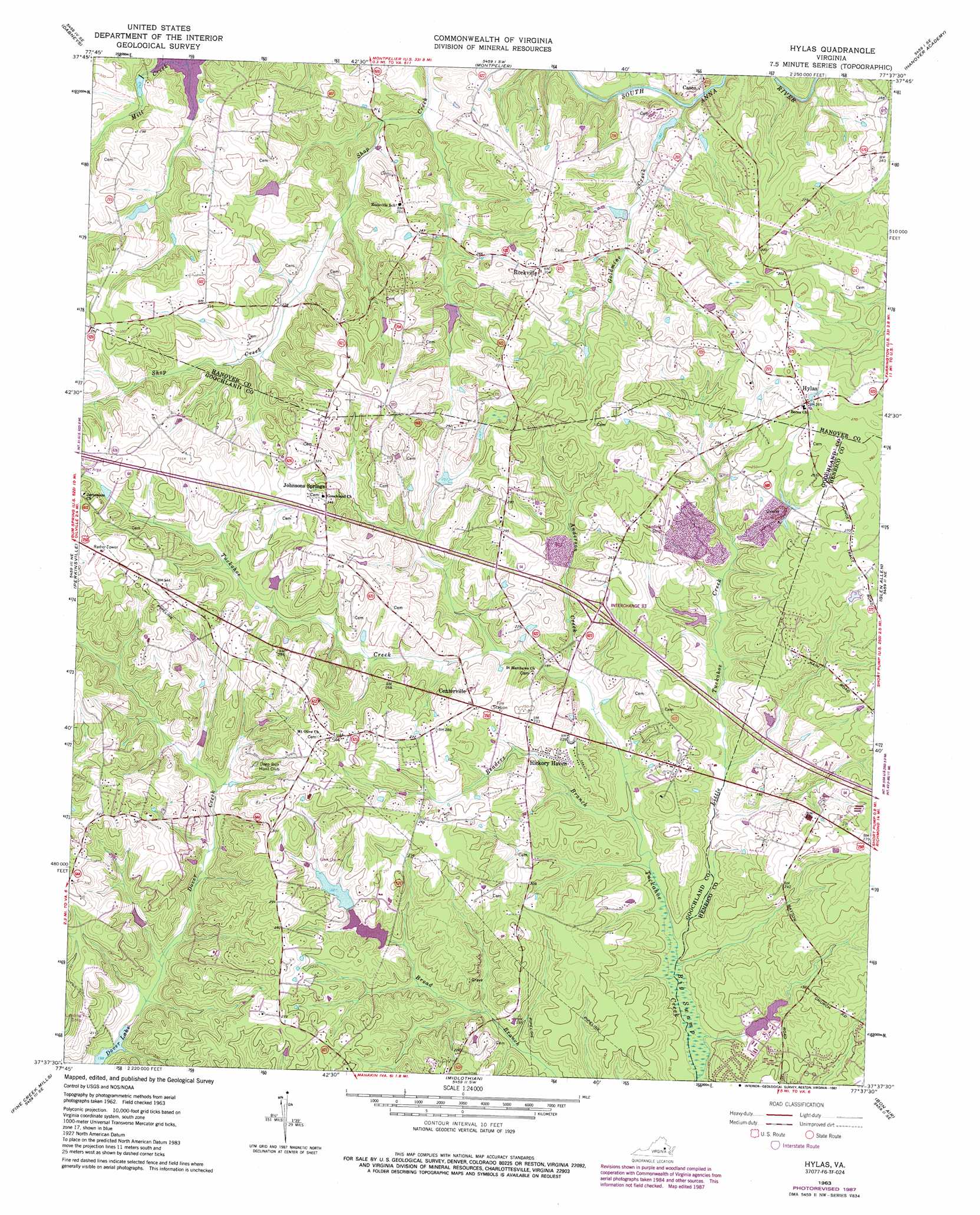
Hylas Topo Map Virginia
To zoom in, hover over the map of Hylas
USGS Topo Quad 37077f6 - 1:24,000 scale
| Topo Map Name: | Hylas |
| USGS Topo Quad ID: | 37077f6 |
| Print Size: | ca. 21 1/4" wide x 27" high |
| Southeast Coordinates: | 37.625° N latitude / 77.625° W longitude |
| Map Center Coordinates: | 37.6875° N latitude / 77.6875° W longitude |
| U.S. State: | VA |
| Filename: | o37077f6.jpg |
| Download Map JPG Image: | Hylas topo map 1:24,000 scale |
| Map Type: | Topographic |
| Topo Series: | 7.5´ |
| Map Scale: | 1:24,000 |
| Source of Map Images: | United States Geological Survey (USGS) |
| Alternate Map Versions: |
Johnsons Springs VA 1943, updated 1961 Download PDF Buy paper map Hylas VA 1963, updated 1965 Download PDF Buy paper map Hylas VA 1963, updated 1973 Download PDF Buy paper map Hylas VA 1963, updated 1987 Download PDF Buy paper map Hylas VA 1994, updated 1996 Download PDF Buy paper map Hylas VA 2010 Download PDF Buy paper map Hylas VA 2013 Download PDF Buy paper map Hylas VA 2016 Download PDF Buy paper map |
1:24,000 Topo Quads surrounding Hylas
Pendleton |
Buckner |
Beaverdam |
Hewlett |
Ruther Glen |
South Anna |
Dabneys |
Montpelier |
Hanover Academy |
Ashland |
Goochland |
Perkinsville |
Hylas |
Glen Allen |
Yellow Tavern |
Powhatan |
Fine Creek Mills |
Midlothian |
Bon Air |
Richmond |
Chula |
Clayville |
Hallsboro |
Chesterfield |
Drewrys Bluff |
> Back to 37077e1 at 1:100,000 scale
> Back to 37076a1 at 1:250,000 scale
> Back to U.S. Topo Maps home
Hylas topo map: Gazetteer
Hylas: Airports
Rockville Airport elevation 83m 272′Sabot Airport elevation 79m 259′
Hylas: Crossings
Interchange 173 elevation 77m 252′Hylas: Dams
Broad Branch Dam elevation 76m 249′Childress Dam elevation 89m 291′
Cochran Dam elevation 65m 213′
Hylas: Mines
Anderson Creek Quarry elevation 72m 236′Hylas: Populated Places
Auburn Chase elevation 75m 246′Bellview Gardens elevation 70m 229′
Brittland elevation 94m 308′
Broad Run elevation 81m 265′
Casco elevation 54m 177′
Centerville elevation 84m 275′
Dawnington Sabot elevation 107m 351′
Dover Run elevation 93m 305′
Fords elevation 99m 324′
Gayton (historical) elevation 60m 196′
Goosepoint elevation 81m 265′
Hermitage Hamlet elevation 79m 259′
Hickory Haven elevation 69m 226′
Homewood Park elevation 110m 360′
Hylas elevation 84m 275′
Johnsons Springs elevation 102m 334′
Mount Olive Terrace elevation 105m 344′
Nelwood Estates elevation 100m 328′
Oak Grove Estates elevation 71m 232′
Pickels elevation 93m 305′
Rockville elevation 96m 314′
Samary Forest elevation 61m 200′
Sycamore Creek elevation 85m 278′
Wheatlands elevation 106m 347′
Windy Run elevation 103m 337′
Wingmead elevation 59m 193′
Woods Acres elevation 81m 265′
Hylas: Reservoirs
Broad Branch Lake elevation 76m 249′Dover Lake elevation 48m 157′
Hylas: Streams
Anderson Creek elevation 56m 183′Goldmine Creek elevation 49m 160′
Harding Branch elevation 43m 141′
Little Tuckahoe Creek elevation 47m 154′
Readers Branch elevation 49m 160′
Hylas: Swamps
Big Swamp elevation 46m 150′Hylas digital topo map on disk
Buy this Hylas topo map showing relief, roads, GPS coordinates and other geographical features, as a high-resolution digital map file on DVD:
Atlantic Coast (NY, NJ, PA, DE, MD, VA, NC)
Buy digital topo maps: Atlantic Coast (NY, NJ, PA, DE, MD, VA, NC)
 map DVD")