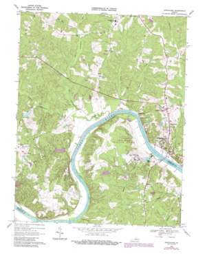
Goochland Topo Map Virginia
To zoom in, hover over the map of Goochland
USGS Topo Quad 37077f8 - 1:24,000 scale
| Topo Map Name: | Goochland |
| USGS Topo Quad ID: | 37077f8 |
| Print Size: | ca. 21 1/4" wide x 27" high |
| Southeast Coordinates: | 37.625° N latitude / 77.875° W longitude |
| Map Center Coordinates: | 37.6875° N latitude / 77.9375° W longitude |
| U.S. State: | VA |
| Filename: | o37077f8.jpg |
| Download Map JPG Image: | Goochland topo map 1:24,000 scale |
| Map Type: | Topographic |
| Topo Series: | 7.5´ |
| Map Scale: | 1:24,000 |
| Source of Map Images: | United States Geological Survey (USGS) |
| Alternate Map Versions: |
Goochland VA 1943, updated 1961 Download PDF Buy paper map Goochland VA 1968, updated 1970 Download PDF Buy paper map Goochland VA 1968, updated 1977 Download PDF Buy paper map Goochland VA 1968, updated 1987 Download PDF Buy paper map Goochland VA 1968, updated 1987 Download PDF Buy paper map Goochland VA 1979, updated 1982 Download PDF Buy paper map Goochland VA 2010 Download PDF Buy paper map Goochland VA 2013 Download PDF Buy paper map Goochland VA 2016 Download PDF Buy paper map |
1:24,000 Topo Quads surrounding Goochland
> Back to 37077e1 at 1:100,000 scale
> Back to 37076a1 at 1:250,000 scale
> Back to U.S. Topo Maps home
Goochland topo map: Gazetteer
Goochland: Airports
Rose Retreat Farm Airport elevation 85m 278′Goochland: Bridges
Michaux Bridge elevation 42m 137′Goochland: Crossings
Atkinsons Ferry (historical) elevation 42m 137′Goochland: Dams
Bolling Hall Dam elevation 52m 170′Fairfield Dam elevation 57m 187′
Gathrights Dam elevation 66m 216′
Kelona Farm Dam elevation 68m 223′
Licking Hole Farm Dam elevation 56m 183′
Patterson and Stittius Dam elevation 67m 219′
United Methodist Centers Dam elevation 71m 232′
Virginia Industrial School Dam elevation 60m 196′
Winalls Dam elevation 59m 193′
Goochland: Populated Places
Aldwyck elevation 92m 301′Beaumont elevation 79m 259′
Cedar Hills elevation 75m 246′
Cedar Point elevation 47m 154′
Cheney Creek elevation 100m 328′
Goochland elevation 77m 252′
Irwin elevation 48m 157′
Jefferson (historical) elevation 50m 164′
Maidens elevation 68m 223′
Mayos Woods elevation 94m 308′
Michaux elevation 95m 311′
Three Square elevation 94m 308′
Venice Heights elevation 91m 298′
Village Acres elevation 69m 226′
Goochland: Post Offices
Goochland Post Office elevation 77m 252′Goochland: Reservoirs
Bolling Hall Lake elevation 52m 170′Fairfield Pond elevation 57m 187′
Grigg Lake elevation 46m 150′
Kelona Farm Pond elevation 68m 223′
Licking Hole Farm Pond elevation 56m 183′
Virginia Industrial School Lake elevation 60m 196′
Goochland: Streams
Big Lickinghole Creek elevation 45m 147′Cheneys Creek elevation 46m 150′
Little Creek elevation 45m 147′
Little Lickinghole Creek elevation 48m 157′
Mohawk Creek elevation 43m 141′
Old Miss Branch elevation 54m 177′
Solomons Creek elevation 46m 150′
Three Square Creek elevation 45m 147′
Walkers Creek elevation 50m 164′
Goochland digital topo map on disk
Buy this Goochland topo map showing relief, roads, GPS coordinates and other geographical features, as a high-resolution digital map file on DVD:
Atlantic Coast (NY, NJ, PA, DE, MD, VA, NC)
Buy digital topo maps: Atlantic Coast (NY, NJ, PA, DE, MD, VA, NC)


