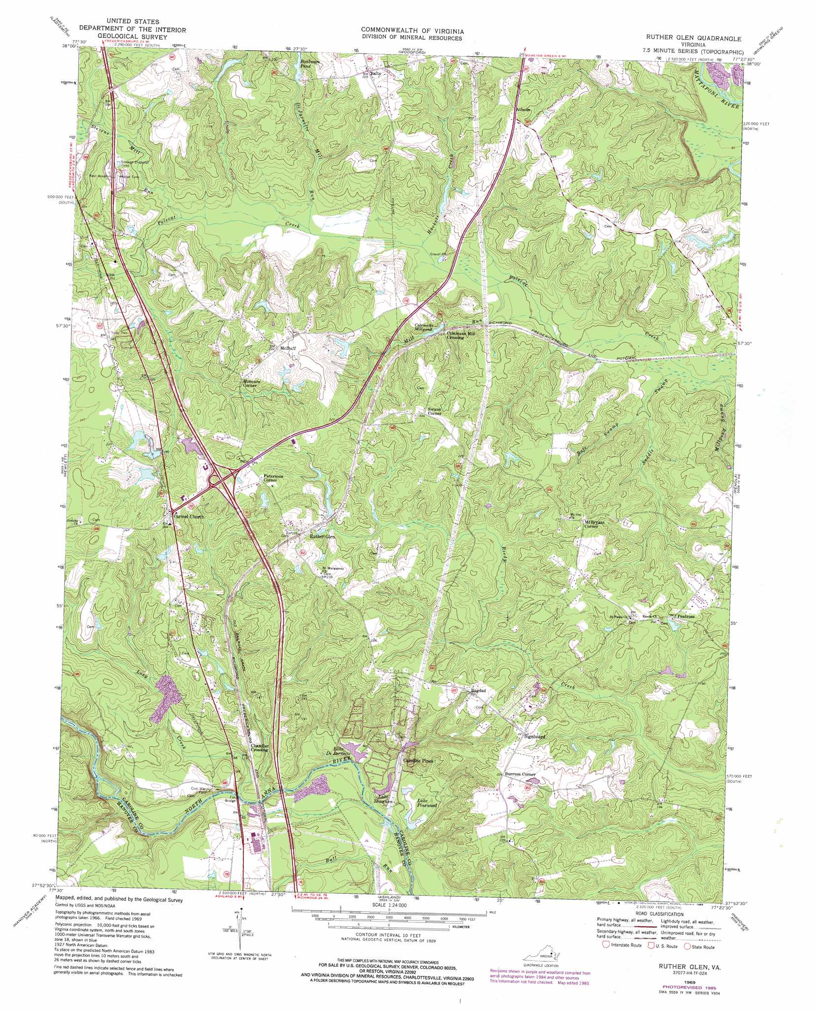
Ruther Glen Topo Map Virginia
To zoom in, hover over the map of Ruther Glen
USGS Topo Quad 37077h4 - 1:24,000 scale
| Topo Map Name: | Ruther Glen |
| USGS Topo Quad ID: | 37077h4 |
| Print Size: | ca. 21 1/4" wide x 27" high |
| Southeast Coordinates: | 37.875° N latitude / 77.375° W longitude |
| Map Center Coordinates: | 37.9375° N latitude / 77.4375° W longitude |
| U.S. State: | VA |
| Filename: | o37077h4.jpg |
| Download Map JPG Image: | Ruther Glen topo map 1:24,000 scale |
| Map Type: | Topographic |
| Topo Series: | 7.5´ |
| Map Scale: | 1:24,000 |
| Source of Map Images: | United States Geological Survey (USGS) |
| Alternate Map Versions: |
Ruther Glen VA 1949, updated 1964 Download PDF Buy paper map Ruther Glen VA 1951 Download PDF Buy paper map Ruther Glen VA 1969, updated 1971 Download PDF Buy paper map Ruther Glen VA 1969, updated 1975 Download PDF Buy paper map Ruther Glen VA 1969, updated 1985 Download PDF Buy paper map Ruther Glen VA 1969, updated 1985 Download PDF Buy paper map Ruther Glen VA 2010 Download PDF Buy paper map Ruther Glen VA 2013 Download PDF Buy paper map Ruther Glen VA 2016 Download PDF Buy paper map |
1:24,000 Topo Quads surrounding Ruther Glen
Brokenburg |
Spotsylvania |
Guinea |
Rappahannock Academy |
Port Royal |
Lake Anna East |
Ladysmith |
Woodford |
Bowling Green |
Supply |
Beaverdam |
Hewlett |
Ruther Glen |
Penola |
Sparta |
Montpelier |
Hanover Academy |
Ashland |
Hanover |
Beulahville |
Hylas |
Glen Allen |
Yellow Tavern |
Studley |
Manquin |
> Back to 37077e1 at 1:100,000 scale
> Back to 37076a1 at 1:250,000 scale
> Back to U.S. Topo Maps home
Ruther Glen topo map: Gazetteer
Ruther Glen: Bridges
Fox Bridge elevation 26m 85′Ruther Glen: Crossings
Interchange 104 elevation 62m 203′Ruther Glen: Dams
Boulwares Millpond Dam elevation 49m 160′Caroline Pines Dam elevation 22m 72′
Coburn Dam elevation 53m 173′
Lake De Jarnette Dam elevation 23m 75′
Lake Pinewood Dam elevation 22m 72′
R Collins Dam elevation 47m 154′
Ruther Glen: Mines
Carmel Church Quarry elevation 34m 111′Ruther Glen: Populated Places
Athens elevation 69m 226′Bagdad elevation 68m 223′
Balty elevation 70m 229′
Burruss Corner elevation 69m 226′
Caroline Pines elevation 30m 98′
Chandler Crossing elevation 35m 114′
Colemans Mill Crossing elevation 49m 160′
McBryant Corner elevation 68m 223′
McDuff elevation 70m 229′
Moncure Corner elevation 60m 196′
Patersons Corner elevation 73m 239′
Peatross elevation 62m 203′
Ruther Glen elevation 71m 232′
Signboard elevation 68m 223′
Swans Corner elevation 74m 242′
Ruther Glen: Reservoirs
Boulware Pond elevation 49m 160′Boulwares Millpond elevation 43m 141′
Caroline Pines Lake elevation 22m 72′
Colemans Millpond elevation 46m 150′
Lake De Jarnette elevation 26m 85′
Lake DeJarnette elevation 23m 75′
Lake Pinewood elevation 22m 72′
Lake Shannon elevation 22m 72′
Ruther Glen: Streams
Bull Run elevation 21m 68′DeJarnette Mill Run elevation 33m 108′
Hackett Creek elevation 33m 108′
Long Creek elevation 16m 52′
Mill Run elevation 31m 101′
Millpond Swamp elevation 21m 68′
Rafe Swamp elevation 24m 78′
Reedy Swamp elevation 34m 111′
Saddle Swamp elevation 22m 72′
Stevens Mill Run elevation 37m 121′
Ruther Glen digital topo map on disk
Buy this Ruther Glen topo map showing relief, roads, GPS coordinates and other geographical features, as a high-resolution digital map file on DVD:
Atlantic Coast (NY, NJ, PA, DE, MD, VA, NC)
Buy digital topo maps: Atlantic Coast (NY, NJ, PA, DE, MD, VA, NC)
 map DVD")