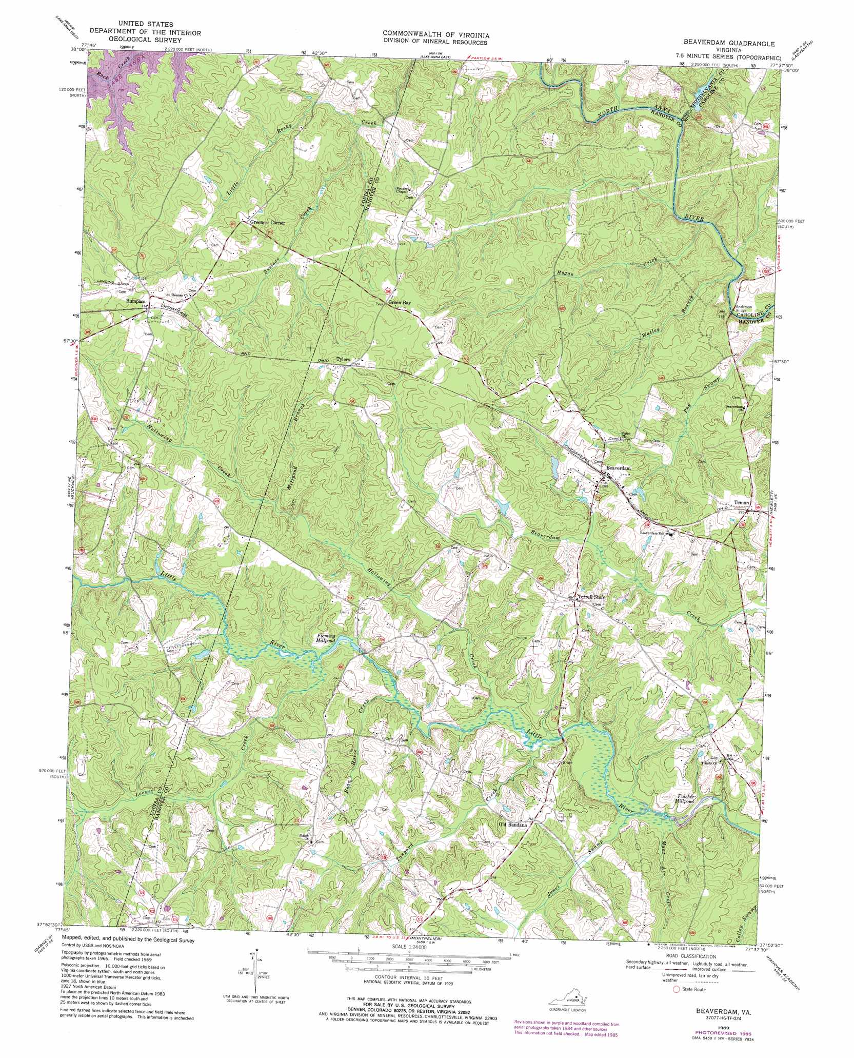
Beaverdam Topo Map Virginia
To zoom in, hover over the map of Beaverdam
USGS Topo Quad 37077h6 - 1:24,000 scale
| Topo Map Name: | Beaverdam |
| USGS Topo Quad ID: | 37077h6 |
| Print Size: | ca. 21 1/4" wide x 27" high |
| Southeast Coordinates: | 37.875° N latitude / 77.625° W longitude |
| Map Center Coordinates: | 37.9375° N latitude / 77.6875° W longitude |
| U.S. State: | VA |
| Filename: | o37077h6.jpg |
| Download Map JPG Image: | Beaverdam topo map 1:24,000 scale |
| Map Type: | Topographic |
| Topo Series: | 7.5´ |
| Map Scale: | 1:24,000 |
| Source of Map Images: | United States Geological Survey (USGS) |
| Alternate Map Versions: |
Beaverdam VA 1942, updated 1961 Download PDF Buy paper map Beaverdam VA 1969, updated 1971 Download PDF Buy paper map Beaverdam VA 1969, updated 1974 Download PDF Buy paper map Beaverdam VA 1969, updated 1985 Download PDF Buy paper map Beaverdam VA 2010 Download PDF Buy paper map Beaverdam VA 2013 Download PDF Buy paper map Beaverdam VA 2016 Download PDF Buy paper map |
1:24,000 Topo Quads surrounding Beaverdam
Lahore |
Belmont |
Brokenburg |
Spotsylvania |
Guinea |
Mineral |
Lake Anna West |
Lake Anna East |
Ladysmith |
Woodford |
Pendleton |
Buckner |
Beaverdam |
Hewlett |
Ruther Glen |
South Anna |
Dabneys |
Montpelier |
Hanover Academy |
Ashland |
Goochland |
Perkinsville |
Hylas |
Glen Allen |
Yellow Tavern |
> Back to 37077e1 at 1:100,000 scale
> Back to 37076a1 at 1:250,000 scale
> Back to U.S. Topo Maps home
Beaverdam topo map: Gazetteer
Beaverdam: Airports
Lake Anna Airport (historical) elevation 106m 347′Beaverdam: Bridges
Anderson Bridge elevation 48m 157′Beaverdam: Dams
James Dam elevation 57m 187′Beaverdam: Populated Places
Beaverdam elevation 87m 285′Bumpass elevation 100m 328′
Green Bay elevation 100m 328′
Greenes Corner elevation 94m 308′
Old Bandana elevation 76m 249′
Snelson (historical) elevation 93m 305′
Teman elevation 89m 291′
Terrell Store elevation 92m 301′
Tylers elevation 99m 324′
Beaverdam: Post Offices
Bumpass Post Office elevation 106m 347′Beaverdam: Reservoirs
Fleming Millpond elevation 61m 200′Fulcher Millpond elevation 54m 177′
James Pond elevation 57m 187′
Beaverdam: Streams
Buzzie Creek elevation 76m 249′Hogan Creek elevation 51m 167′
Hollowing Creek elevation 57m 187′
Jones Swamp elevation 56m 183′
Locust Creek elevation 64m 209′
Millpond Branch elevation 72m 236′
Mont Air Creek elevation 55m 180′
Roan Horse Creek elevation 59m 193′
Snelson Creek elevation 63m 206′
Tanyard Creek elevation 57m 187′
Watleg Branch elevation 51m 167′
Beaverdam digital topo map on disk
Buy this Beaverdam topo map showing relief, roads, GPS coordinates and other geographical features, as a high-resolution digital map file on DVD:
Atlantic Coast (NY, NJ, PA, DE, MD, VA, NC)
Buy digital topo maps: Atlantic Coast (NY, NJ, PA, DE, MD, VA, NC)
 map DVD")