Pendleton Topo Map Virginia
To zoom in, hover over the map of Pendleton
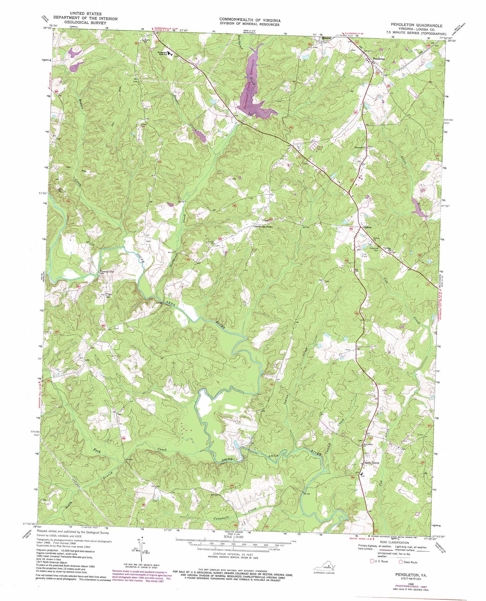
USGS Topo Quad 37077h8 - 1:24,000 scale
| Topo Map Name: | Pendleton |
| USGS Topo Quad ID: | 37077h8 |
| Print Size: | ca. 21 1/4" wide x 27" high |
| Southeast Coordinates: | 37.875° N latitude / 77.875° W longitude |
| Map Center Coordinates: | 37.9375° N latitude / 77.9375° W longitude |
| U.S. State: | VA |
| Filename: | o37077h8.jpg |
| Download Map JPG Image: | Pendleton topo map 1:24,000 scale |
| Map Type: | Topographic |
| Topo Series: | 7.5´ |
| Map Scale: | 1:24,000 |
| Source of Map Images: | United States Geological Survey (USGS) |
| Alternate Map Versions: |
Pendleton VA 1942, updated 1958 Download PDF Buy paper map Pendleton VA 1968, updated 1970 Download PDF Buy paper map Pendleton VA 1968, updated 1987 Download PDF Buy paper map Pendleton VA 2011 Download PDF Buy paper map Pendleton VA 2013 Download PDF Buy paper map Pendleton VA 2016 Download PDF Buy paper map |
1:24,000 Topo Quads surrounding Pendleton
Gordonsville |
Orange |
Lahore |
Belmont |
Brokenburg |
Boswells Tavern |
Louisa |
Mineral |
Lake Anna West |
Lake Anna East |
Zion Crossroads |
Ferncliff |
Pendleton |
Buckner |
Beaverdam |
Columbia |
Caledonia |
South Anna |
Dabneys |
Montpelier |
Lakeside Village |
Cartersville |
Goochland |
Perkinsville |
Hylas |
> Back to 37077e1 at 1:100,000 scale
> Back to 37076a1 at 1:250,000 scale
> Back to U.S. Topo Maps home
Pendleton topo map: Gazetteer
Pendleton: Airports
Cub Field elevation 119m 390′Pendleton: Dams
Little River Number One Dam elevation 87m 285′Woodfolk Brothers Dam Number One elevation 136m 446′
Woodfolk Brothers Dam Number Two elevation 109m 357′
Woolfolks Dam elevation 111m 364′
Yanceyville Dam elevation 108m 354′
Pendleton: Populated Places
Apple Grove elevation 102m 334′Cuckoo elevation 129m 423′
Pendleton elevation 144m 472′
Vigor elevation 106m 347′
Yanceyville elevation 89m 291′
Pendleton: Post Offices
Cuckoo Post Office elevation 129m 423′Pendleton Post Office elevation 144m 472′
Vigor Post Office elevation 106m 347′
Pendleton: Reservoirs
Woodfolk Brothers Pond Number Two elevation 109m 357′Woolfolks Pond elevation 111m 364′
Yanceyville Millpond elevation 108m 354′
Pendleton: Streams
Beaver Creek elevation 80m 262′Campbells Creek elevation 73m 239′
Cattail Creek elevation 76m 249′
Desper Creek elevation 89m 291′
Fork Creek elevation 75m 246′
Indian Creek elevation 78m 255′
Indian Creek elevation 73m 239′
Northeast Creek elevation 79m 259′
South Branch Fork Creek elevation 81m 265′
Pendleton digital topo map on disk
Buy this Pendleton topo map showing relief, roads, GPS coordinates and other geographical features, as a high-resolution digital map file on DVD:
Atlantic Coast (NY, NJ, PA, DE, MD, VA, NC)
Buy digital topo maps: Atlantic Coast (NY, NJ, PA, DE, MD, VA, NC)
 map DVD")