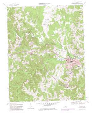
Farmville Topo Map Virginia
To zoom in, hover over the map of Farmville
USGS Topo Quad 37078c4 - 1:24,000 scale
| Topo Map Name: | Farmville |
| USGS Topo Quad ID: | 37078c4 |
| Print Size: | ca. 21 1/4" wide x 27" high |
| Southeast Coordinates: | 37.25° N latitude / 78.375° W longitude |
| Map Center Coordinates: | 37.3125° N latitude / 78.4375° W longitude |
| U.S. State: | VA |
| Filename: | o37078c4.jpg |
| Download Map JPG Image: | Farmville topo map 1:24,000 scale |
| Map Type: | Topographic |
| Topo Series: | 7.5´ |
| Map Scale: | 1:24,000 |
| Source of Map Images: | United States Geological Survey (USGS) |
| Alternate Map Versions: |
Farmville VA 1968, updated 1971 Download PDF Buy paper map Farmville VA 1968, updated 1975 Download PDF Buy paper map Farmville VA 1968, updated 1982 Download PDF Buy paper map Farmville VA 1968, updated 1982 Download PDF Buy paper map Farmville VA 2010 Download PDF Buy paper map Farmville VA 2013 Download PDF Buy paper map Farmville VA 2016 Download PDF Buy paper map |
1:24,000 Topo Quads surrounding Farmville
> Back to 37078a1 at 1:100,000 scale
> Back to 37078a1 at 1:250,000 scale
> Back to U.S. Topo Maps home
Farmville topo map: Gazetteer
Farmville: Airports
Big Buffalo Airstrip elevation 144m 472′Farmville Airport (historical) elevation 108m 354′
Farmville Municipal Airport elevation 121m 396′
Farmville: Bridges
Wilbourne Bridge elevation 100m 328′Farmville: Dams
Atkins Dam elevation 121m 396′Ayers Lower Dam elevation 106m 347′
Ayers Upper Dam elevation 119m 390′
Bridge Street Lagoons Dam elevation 88m 288′
Carlton Dam elevation 104m 341′
Fender Dam elevation 137m 449′
Mottleys Dam elevation 101m 331′
Murphy Dam elevation 140m 459′
Ortel Dam elevation 119m 390′
R A Smith Dam elevation 102m 334′
Simanske Dam elevation 137m 449′
Winkeljohn Dam elevation 113m 370′
Farmville: Parks
Barlow Field elevation 98m 321′Bicentennial Park elevation 107m 351′
Farmville Historic District elevation 98m 321′
Grove Street Park elevation 122m 400′
Iler Field elevation 99m 324′
Lancer Field elevation 121m 396′
Softball Field elevation 116m 380′
Wheeler Mall elevation 109m 357′
Wilcks Lake Public Area elevation 94m 308′
Farmville: Populated Places
Farmville elevation 94m 308′Kimberly Hills elevation 138m 452′
Reeds elevation 115m 377′
Tuggle elevation 150m 492′
Farmville: Post Offices
Farmville Post Office elevation 94m 308′Farmville: Reservoirs
Atkins Pond elevation 121m 396′Carlton Pond elevation 104m 341′
Mottleys Lake elevation 101m 331′
Farmville: Streams
Buffalo Creek elevation 91m 298′Dry Creek elevation 91m 298′
Falling Creek elevation 110m 360′
Gannaway Creek elevation 93m 305′
Gross Creek elevation 88m 288′
Horsepen Creek elevation 97m 318′
Little Buffalo Creek elevation 92m 301′
Locket Creek elevation 105m 344′
Long Branch elevation 103m 337′
Farmville digital topo map on disk
Buy this Farmville topo map showing relief, roads, GPS coordinates and other geographical features, as a high-resolution digital map file on DVD:
Western Virginia & Southern West Virginia
Buy digital topo maps: Western Virginia & Southern West Virginia


