Lakeside Village Topo Map Virginia
To zoom in, hover over the map of Lakeside Village
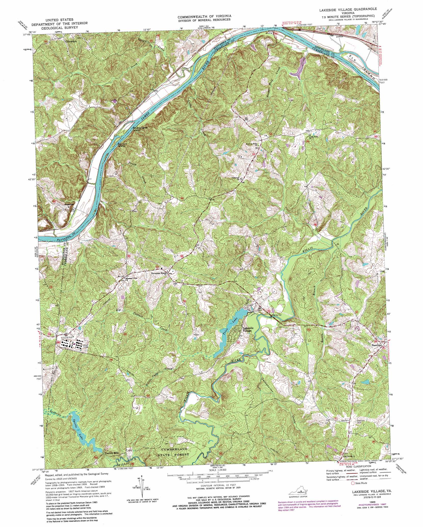
USGS Topo Quad 37078f2 - 1:24,000 scale
| Topo Map Name: | Lakeside Village |
| USGS Topo Quad ID: | 37078f2 |
| Print Size: | ca. 21 1/4" wide x 27" high |
| Southeast Coordinates: | 37.625° N latitude / 78.125° W longitude |
| Map Center Coordinates: | 37.6875° N latitude / 78.1875° W longitude |
| U.S. State: | VA |
| Filename: | o37078f2.jpg |
| Download Map JPG Image: | Lakeside Village topo map 1:24,000 scale |
| Map Type: | Topographic |
| Topo Series: | 7.5´ |
| Map Scale: | 1:24,000 |
| Source of Map Images: | United States Geological Survey (USGS) |
| Alternate Map Versions: |
Lakeside Village VA 1969, updated 1971 Download PDF Buy paper map Lakeside Village VA 1969, updated 1987 Download PDF Buy paper map Lakeside Village VA 2010 Download PDF Buy paper map Lakeside Village VA 2013 Download PDF Buy paper map Lakeside Village VA 2016 Download PDF Buy paper map |
1:24,000 Topo Quads surrounding Lakeside Village
Simeon |
Boyd Tavern |
Zion Crossroads |
Ferncliff |
Pendleton |
Scottsville |
Palmyra |
Columbia |
Caledonia |
South Anna |
Diana Mills |
Arvonia |
Lakeside Village |
Cartersville |
Goochland |
Dillwyn |
Gold Hill |
Whiteville |
Trenholm |
Powhatan |
Willis Mountain |
Hillcrest |
Cumberland |
Ballsville |
Chula |
> Back to 37078e1 at 1:100,000 scale
> Back to 37078a1 at 1:250,000 scale
> Back to U.S. Topo Maps home
Lakeside Village topo map: Gazetteer
Lakeside Village: Dams
Leon Hanson Dam elevation 65m 213′Robertson Dam elevation 89m 291′
Sports Dam elevation 67m 219′
Trice Dam elevation 64m 209′
Lakeside Village: Islands
Boatwrights Island elevation 62m 203′Spicers Island elevation 60m 196′
Lakeside Village: Populated Places
Boswell (historical) elevation 63m 206′Bush Park (historical) elevation 115m 377′
Cremona (historical) elevation 105m 344′
Lakeside Village elevation 74m 242′
Stearnes elevation 99m 324′
Trenton Mills elevation 66m 216′
Lakeside Village: Reservoirs
Leon Hanson Pond elevation 65m 213′Sports Lake elevation 67m 219′
Trice Lake elevation 64m 209′
Lakeside Village: Streams
Big Cattail Creek elevation 58m 190′Boston Branch elevation 54m 177′
Cobbs Creek elevation 62m 203′
Georgia Branch elevation 68m 223′
Hooper Rock Creek elevation 53m 173′
Little Cattail Creek elevation 66m 216′
North Creek elevation 59m 193′
Punch Creek elevation 58m 190′
Randolph Creek elevation 64m 209′
Snowquarter Creek elevation 58m 190′
South Creek elevation 59m 193′
Lakeside Village: Trails
James River Batteau Festival Trail elevation 55m 180′Lakeside Village digital topo map on disk
Buy this Lakeside Village topo map showing relief, roads, GPS coordinates and other geographical features, as a high-resolution digital map file on DVD:
Western Virginia & Southern West Virginia
Buy digital topo maps: Western Virginia & Southern West Virginia