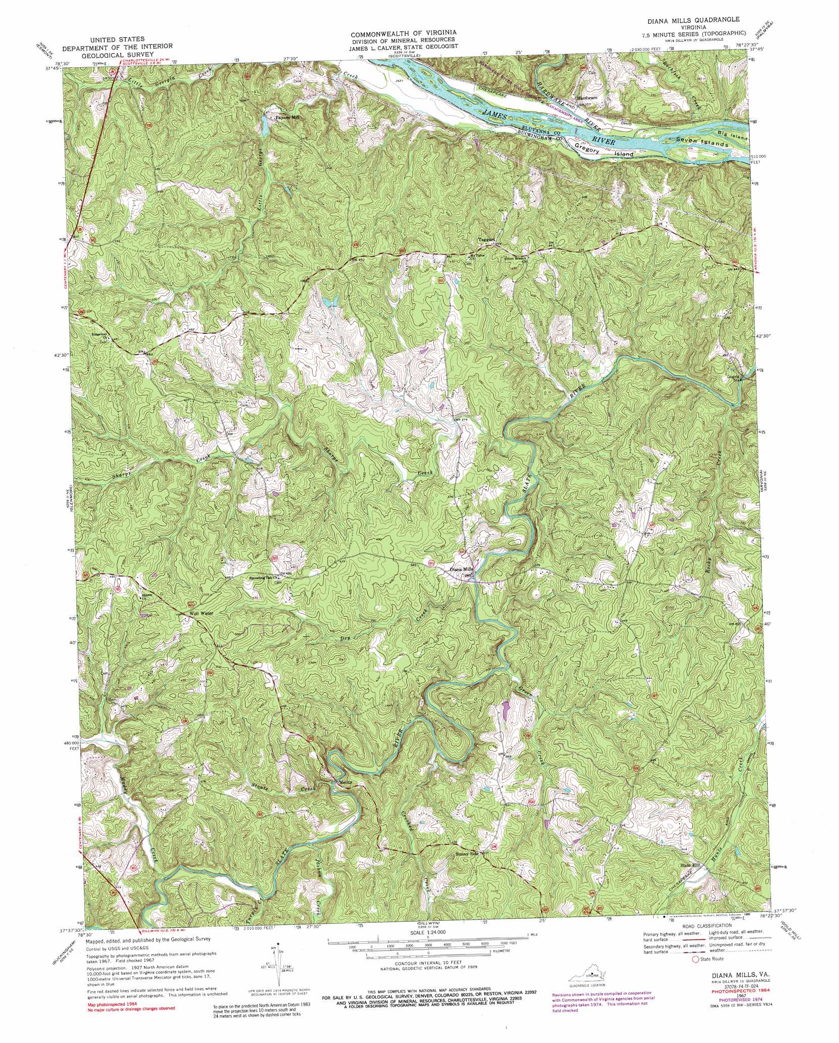
Diana Mills Topo Map Virginia
To zoom in, hover over the map of Diana Mills
USGS Topo Quad 37078f4 - 1:24,000 scale
| Topo Map Name: | Diana Mills |
| USGS Topo Quad ID: | 37078f4 |
| Print Size: | ca. 21 1/4" wide x 27" high |
| Southeast Coordinates: | 37.625° N latitude / 78.375° W longitude |
| Map Center Coordinates: | 37.6875° N latitude / 78.4375° W longitude |
| U.S. State: | VA |
| Filename: | o37078f4.jpg |
| Download Map JPG Image: | Diana Mills topo map 1:24,000 scale |
| Map Type: | Topographic |
| Topo Series: | 7.5´ |
| Map Scale: | 1:24,000 |
| Source of Map Images: | United States Geological Survey (USGS) |
| Alternate Map Versions: |
Diana Mills VA 1967, updated 1971 Download PDF Buy paper map Diana Mills VA 1967, updated 1976 Download PDF Buy paper map Diana Mills VA 1967, updated 1985 Download PDF Buy paper map Diana Mills VA 1967, updated 1989 Download PDF Buy paper map Diana Mills VA 2010 Download PDF Buy paper map Diana Mills VA 2013 Download PDF Buy paper map Diana Mills VA 2016 Download PDF Buy paper map |
1:24,000 Topo Quads surrounding Diana Mills
Covesville |
Alberene |
Simeon |
Boyd Tavern |
Zion Crossroads |
Schuyler |
Esmont |
Scottsville |
Palmyra |
Columbia |
Howardsville |
Glenmore |
Diana Mills |
Arvonia |
Lakeside Village |
Saint Joy |
Buckingham |
Dillwyn |
Gold Hill |
Whiteville |
Holiday Lake |
Andersonville |
Willis Mountain |
Hillcrest |
Cumberland |
> Back to 37078e1 at 1:100,000 scale
> Back to 37078a1 at 1:250,000 scale
> Back to U.S. Topo Maps home
Diana Mills topo map: Gazetteer
Diana Mills: Dams
Martin Dam elevation 119m 390′Diana Mills: Islands
Gregory Island elevation 76m 249′Seven Islands elevation 76m 249′
Diana Mills: Populated Places
Hardware elevation 79m 259′Paynes Mill elevation 105m 344′
Slate Hill elevation 116m 380′
Sunny Side elevation 139m 456′
Taggart elevation 143m 469′
Diana Mills: Post Offices
Diana Mills Post Office (historical) elevation 108m 354′Diana Mills: Streams
Crooked Creek elevation 85m 278′Dry Creek elevation 82m 269′
Green Creek elevation 85m 278′
Hardware River elevation 73m 239′
Joshua Creek elevation 88m 288′
Little George Creek elevation 73m 239′
Muddy Creek elevation 96m 314′
Rockfish Creek elevation 71m 232′
Rocky Creek elevation 76m 249′
Sharps Creek elevation 77m 252′
Stouts Creek elevation 88m 288′
Turpin Creek elevation 92m 301′
Diana Mills digital topo map on disk
Buy this Diana Mills topo map showing relief, roads, GPS coordinates and other geographical features, as a high-resolution digital map file on DVD:
Western Virginia & Southern West Virginia
Buy digital topo maps: Western Virginia & Southern West Virginia