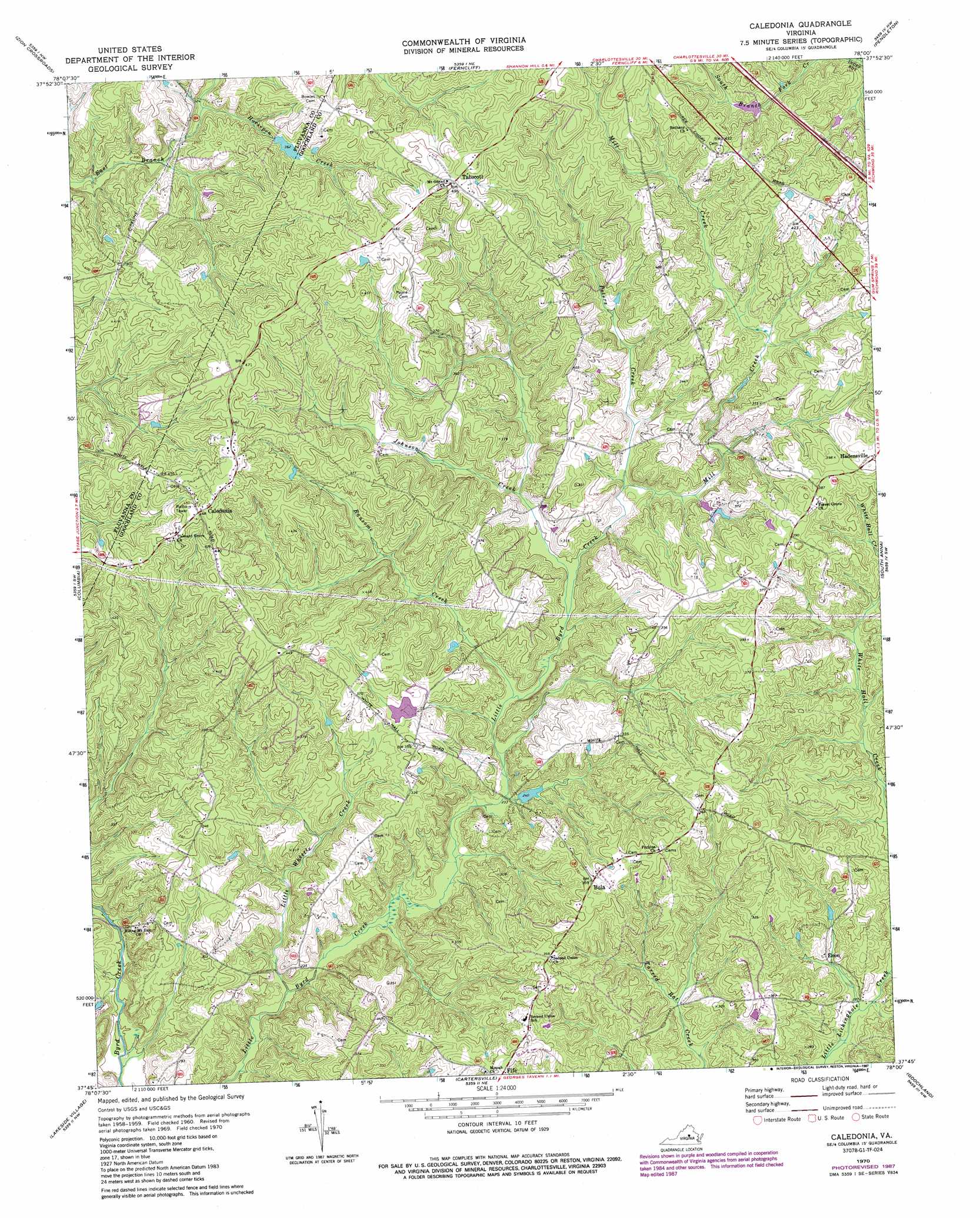
Caledonia Topo Map Virginia
To zoom in, hover over the map of Caledonia
USGS Topo Quad 37078g1 - 1:24,000 scale
| Topo Map Name: | Caledonia |
| USGS Topo Quad ID: | 37078g1 |
| Print Size: | ca. 21 1/4" wide x 27" high |
| Southeast Coordinates: | 37.75° N latitude / 78° W longitude |
| Map Center Coordinates: | 37.8125° N latitude / 78.0625° W longitude |
| U.S. State: | VA |
| Filename: | o37078g1.jpg |
| Download Map JPG Image: | Caledonia topo map 1:24,000 scale |
| Map Type: | Topographic |
| Topo Series: | 7.5´ |
| Map Scale: | 1:24,000 |
| Source of Map Images: | United States Geological Survey (USGS) |
| Alternate Map Versions: |
Caledonia VA 1970, updated 1972 Download PDF Buy paper map Caledonia VA 1970, updated 1987 Download PDF Buy paper map Caledonia VA 2010 Download PDF Buy paper map Caledonia VA 2013 Download PDF Buy paper map Caledonia VA 2016 Download PDF Buy paper map |
1:24,000 Topo Quads surrounding Caledonia
Keswick |
Boswells Tavern |
Louisa |
Mineral |
Lake Anna West |
Boyd Tavern |
Zion Crossroads |
Ferncliff |
Pendleton |
Buckner |
Palmyra |
Columbia |
Caledonia |
South Anna |
Dabneys |
Arvonia |
Lakeside Village |
Cartersville |
Goochland |
Perkinsville |
Gold Hill |
Whiteville |
Trenholm |
Powhatan |
Fine Creek Mills |
> Back to 37078e1 at 1:100,000 scale
> Back to 37078a1 at 1:250,000 scale
> Back to U.S. Topo Maps home
Caledonia topo map: Gazetteer
Caledonia: Airports
Byrd Creek Airport elevation 94m 308′Caledonia: Dams
Bonneys Dam elevation 76m 249′Bowles Dam elevation 110m 360′
Mayo-Alexander and Hadens Dam elevation 98m 321′
Windsor Park Lake Dam elevation 103m 337′
Caledonia: Populated Places
Bula elevation 109m 357′Caledonia elevation 142m 465′
Chimney Springs elevation 111m 364′
Enon elevation 82m 269′
Georges Landing elevation 77m 252′
Hidden Acres elevation 127m 416′
Royal Oaks Estates elevation 134m 439′
Shannon Hills Farms elevation 143m 469′
Tabscott elevation 150m 492′
Tabscott East elevation 135m 442′
Windsor Park elevation 131m 429′
Caledonia: Reservoirs
Bonneys Pond elevation 76m 249′Bowles Pond elevation 110m 360′
Caledonia: Streams
Horsepen Creek elevation 96m 314′Johnson Creek elevation 74m 242′
Little White Creek elevation 78m 255′
Little Whittle Creek elevation 60m 196′
Mill Creek elevation 79m 259′
Peters Creek elevation 79m 259′
Ransome Creek elevation 71m 232′
Rattlesnake Run elevation 96m 314′
Caledonia digital topo map on disk
Buy this Caledonia topo map showing relief, roads, GPS coordinates and other geographical features, as a high-resolution digital map file on DVD:
Western Virginia & Southern West Virginia
Buy digital topo maps: Western Virginia & Southern West Virginia