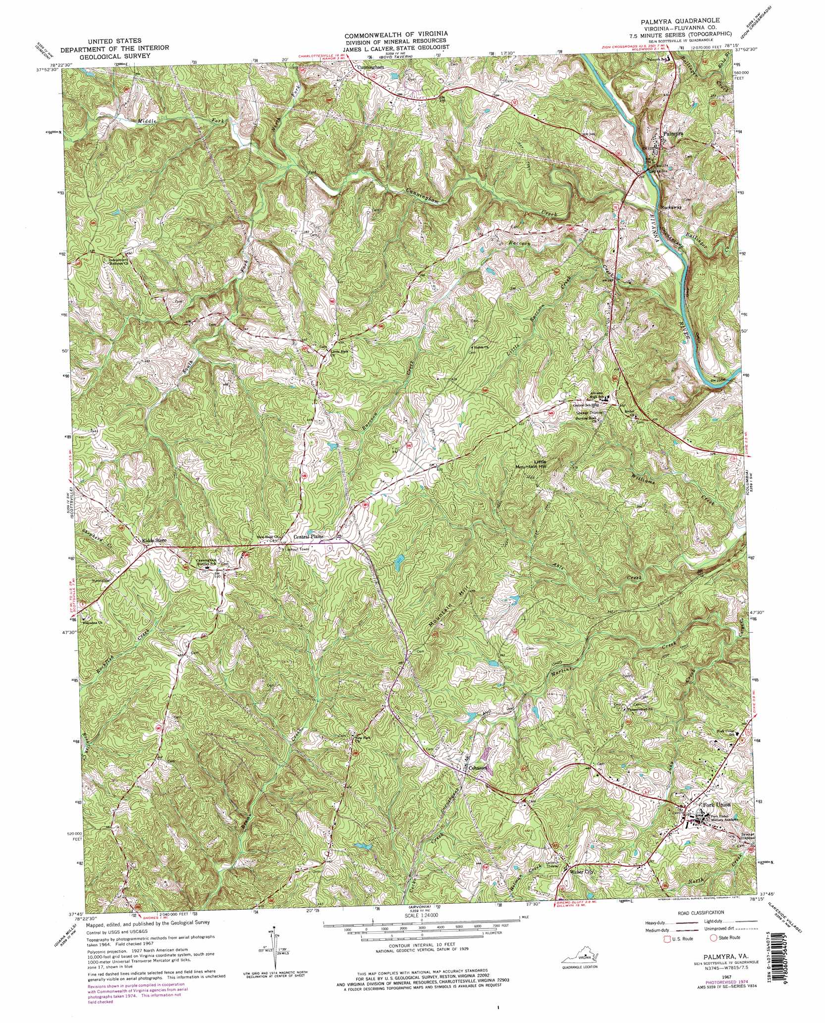
Palmyra Topo Map Virginia
To zoom in, hover over the map of Palmyra
USGS Topo Quad 37078g3 - 1:24,000 scale
| Topo Map Name: | Palmyra |
| USGS Topo Quad ID: | 37078g3 |
| Print Size: | ca. 21 1/4" wide x 27" high |
| Southeast Coordinates: | 37.75° N latitude / 78.25° W longitude |
| Map Center Coordinates: | 37.8125° N latitude / 78.3125° W longitude |
| U.S. State: | VA |
| Filename: | o37078g3.jpg |
| Download Map JPG Image: | Palmyra topo map 1:24,000 scale |
| Map Type: | Topographic |
| Topo Series: | 7.5´ |
| Map Scale: | 1:24,000 |
| Source of Map Images: | United States Geological Survey (USGS) |
| Alternate Map Versions: |
Palmyra VA 1967, updated 1968 Download PDF Buy paper map Palmyra VA 1967, updated 1975 Download PDF Buy paper map Palmyra VA 1967, updated 1975 Download PDF Buy paper map Palmyra VA 2010 Download PDF Buy paper map Palmyra VA 2013 Download PDF Buy paper map Palmyra VA 2016 Download PDF Buy paper map |
1:24,000 Topo Quads surrounding Palmyra
Charlottesville West |
Charlottesville East |
Keswick |
Boswells Tavern |
Louisa |
Alberene |
Simeon |
Boyd Tavern |
Zion Crossroads |
Ferncliff |
Esmont |
Scottsville |
Palmyra |
Columbia |
Caledonia |
Glenmore |
Diana Mills |
Arvonia |
Lakeside Village |
Cartersville |
Buckingham |
Dillwyn |
Gold Hill |
Whiteville |
Trenholm |
> Back to 37078e1 at 1:100,000 scale
> Back to 37078a1 at 1:250,000 scale
> Back to U.S. Topo Maps home
Palmyra topo map: Gazetteer
Palmyra: Bridges
Pembroke Petit Bridge elevation 65m 213′Palmyra: Parks
Fluvanna County Courthouse Historic District elevation 98m 321′Palmyra: Populated Places
Cohasset elevation 120m 393′Cunningham elevation 126m 413′
Fork Union elevation 109m 357′
Kidds Store elevation 151m 495′
Palmyra elevation 92m 301′
Rockaway elevation 81m 265′
Weber City elevation 143m 469′
Palmyra: Streams
Ballinger Creek elevation 66m 216′Bold Branch elevation 87m 285′
Cunningham Creek elevation 68m 223′
Judy Creek elevation 69m 226′
Little Raccoon Creek elevation 76m 249′
Martins Creek elevation 69m 226′
Middle Fork Cunningham Creek elevation 68m 223′
North Fork Cunningham Creek elevation 79m 259′
Raccoon Creek elevation 63m 206′
South Fork Cunningham Creek elevation 79m 259′
Palmyra: Summits
Little Mountain Hill elevation 157m 515′Mountain Hill elevation 153m 501′
Palmyra digital topo map on disk
Buy this Palmyra topo map showing relief, roads, GPS coordinates and other geographical features, as a high-resolution digital map file on DVD:
Western Virginia & Southern West Virginia
Buy digital topo maps: Western Virginia & Southern West Virginia