Scottsville Topo Map Virginia
To zoom in, hover over the map of Scottsville
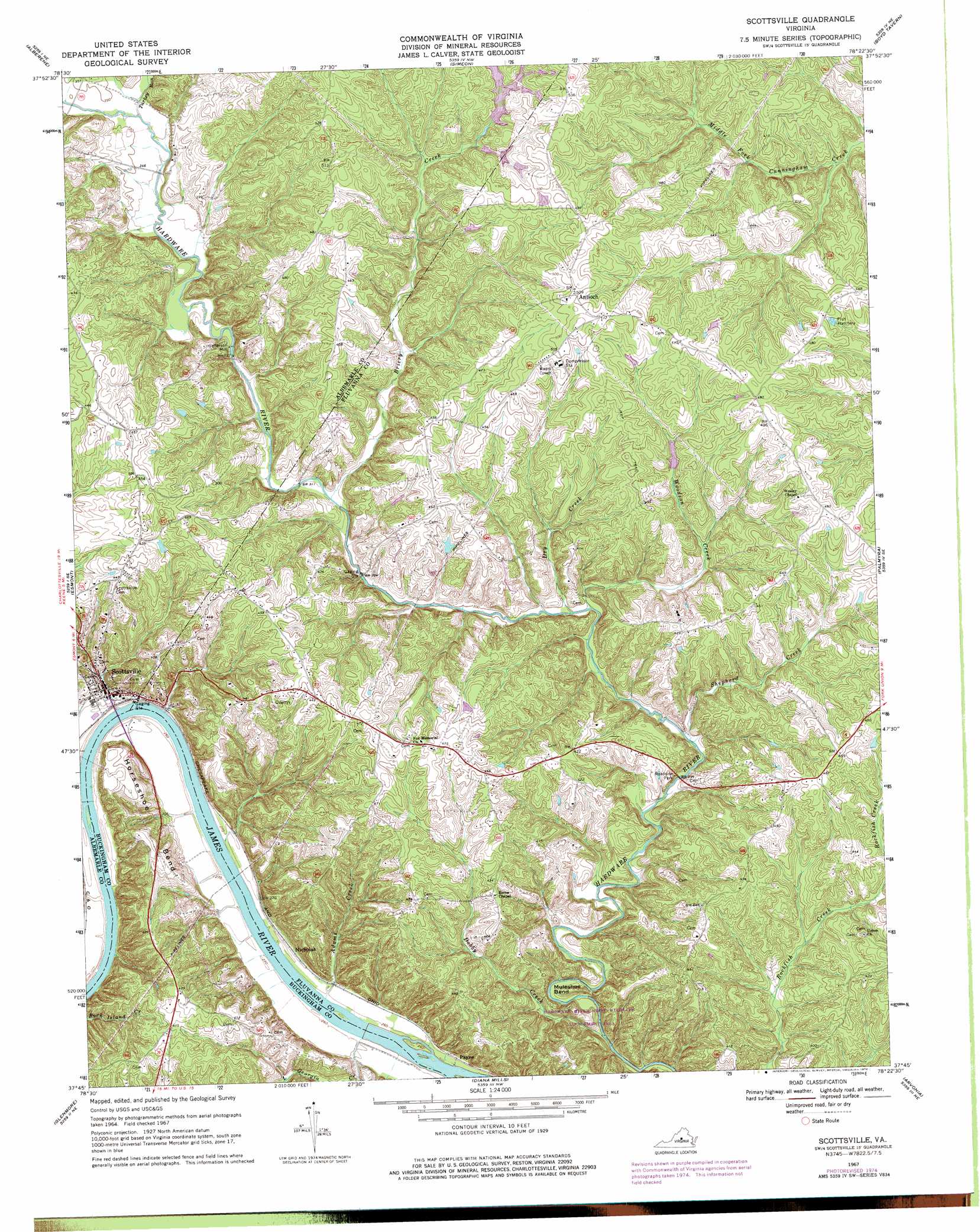
USGS Topo Quad 37078g4 - 1:24,000 scale
| Topo Map Name: | Scottsville |
| USGS Topo Quad ID: | 37078g4 |
| Print Size: | ca. 21 1/4" wide x 27" high |
| Southeast Coordinates: | 37.75° N latitude / 78.375° W longitude |
| Map Center Coordinates: | 37.8125° N latitude / 78.4375° W longitude |
| U.S. State: | VA |
| Filename: | o37078g4.jpg |
| Download Map JPG Image: | Scottsville topo map 1:24,000 scale |
| Map Type: | Topographic |
| Topo Series: | 7.5´ |
| Map Scale: | 1:24,000 |
| Source of Map Images: | United States Geological Survey (USGS) |
| Alternate Map Versions: |
Scottsville VA 1967, updated 1969 Download PDF Buy paper map Scottsville VA 1967, updated 1976 Download PDF Buy paper map Scottsville VA 2010 Download PDF Buy paper map Scottsville VA 2013 Download PDF Buy paper map Scottsville VA 2016 Download PDF Buy paper map |
1:24,000 Topo Quads surrounding Scottsville
Crozet |
Charlottesville West |
Charlottesville East |
Keswick |
Boswells Tavern |
Covesville |
Alberene |
Simeon |
Boyd Tavern |
Zion Crossroads |
Schuyler |
Esmont |
Scottsville |
Palmyra |
Columbia |
Howardsville |
Glenmore |
Diana Mills |
Arvonia |
Lakeside Village |
Saint Joy |
Buckingham |
Dillwyn |
Gold Hill |
Whiteville |
> Back to 37078e1 at 1:100,000 scale
> Back to 37078a1 at 1:250,000 scale
> Back to U.S. Topo Maps home
Scottsville topo map: Gazetteer
Scottsville: Bends
Horseshoe Bend elevation 112m 367′Muleshoe Bend elevation 86m 282′
Scottsville: Dams
Mink Creek Dam elevation 95m 311′T Potts Dam Number One elevation 114m 374′
T Potts Dam Number Three elevation 153m 501′
T Potts Dam Number Two elevation 146m 479′
Thomas Dam elevation 132m 433′
Scottsville: Parks
Hardware River State Wildlife Management Are elevation 100m 328′Scottsville Historic District elevation 87m 285′
Scottsville: Populated Places
Antioch elevation 153m 501′Nicholas elevation 82m 269′
Payne elevation 80m 262′
Scottsville elevation 85m 278′
Stony Point elevation 134m 439′
Scottsville: Post Offices
Scottsville Post Office elevation 85m 278′Scottsville: Reservoirs
Mink Creek elevation 95m 311′Scottsville: Streams
Adams Creek elevation 77m 252′Briery Creek elevation 91m 298′
Dry Creek elevation 88m 288′
Little Georgia Creek elevation 76m 249′
Shepherd Creek elevation 85m 278′
Totier Creek elevation 80m 262′
Turkey Run elevation 102m 334′
Woodson Creek elevation 87m 285′
Scottsville digital topo map on disk
Buy this Scottsville topo map showing relief, roads, GPS coordinates and other geographical features, as a high-resolution digital map file on DVD:
Western Virginia & Southern West Virginia
Buy digital topo maps: Western Virginia & Southern West Virginia