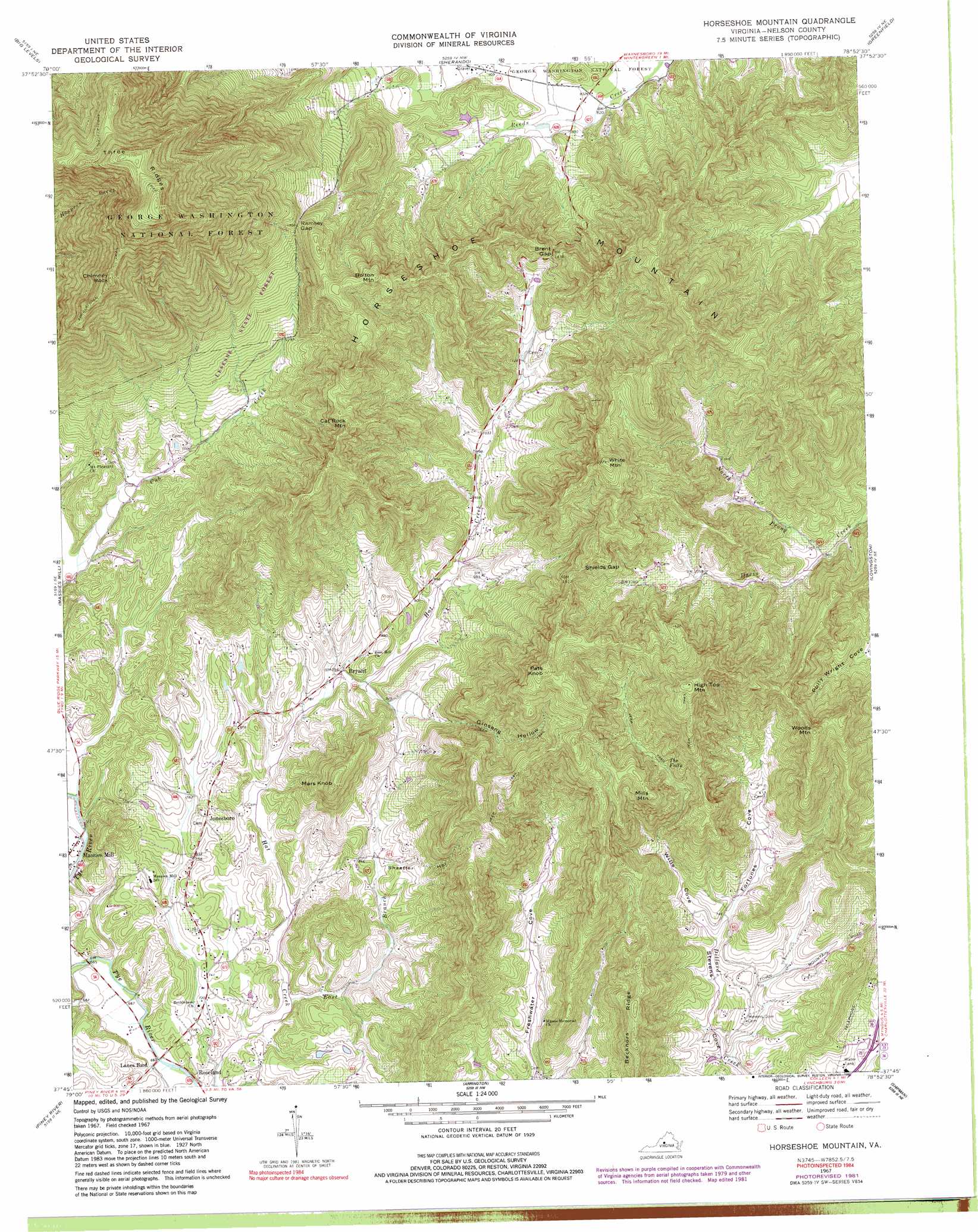
Horseshoe Mountain Topo Map Virginia
To zoom in, hover over the map of Horseshoe Mountain
USGS Topo Quad 37078g8 - 1:24,000 scale
| Topo Map Name: | Horseshoe Mountain |
| USGS Topo Quad ID: | 37078g8 |
| Print Size: | ca. 21 1/4" wide x 27" high |
| Southeast Coordinates: | 37.75° N latitude / 78.875° W longitude |
| Map Center Coordinates: | 37.8125° N latitude / 78.9375° W longitude |
| U.S. State: | VA |
| Filename: | o37078g8.jpg |
| Download Map JPG Image: | Horseshoe Mountain topo map 1:24,000 scale |
| Map Type: | Topographic |
| Topo Series: | 7.5´ |
| Map Scale: | 1:24,000 |
| Source of Map Images: | United States Geological Survey (USGS) |
| Alternate Map Versions: |
Horseshoe Mountain VA 1967, updated 1970 Download PDF Buy paper map Horseshoe Mountain VA 1967, updated 1981 Download PDF Buy paper map Horseshoe Mountain VA 1967, updated 1982 Download PDF Buy paper map Horseshoe Mountain VA 1967, updated 1991 Download PDF Buy paper map Horseshoe Mountain VA 1967, updated 1994 Download PDF Buy paper map Horseshoe Mountain VA 1999, updated 2000 Download PDF Buy paper map Horseshoe Mountain VA 2011 Download PDF Buy paper map Horseshoe Mountain VA 2013 Download PDF Buy paper map Horseshoe Mountain VA 2016 Download PDF Buy paper map |
| FStopo: | US Forest Service topo Horseshoe Mountain is available: Download FStopo PDF Download FStopo TIF |
1:24,000 Topo Quads surrounding Horseshoe Mountain
Greenville |
Stuarts Draft |
Waynesboro West |
Waynesboro East |
Crozet |
Vesuvius |
Big Levels |
Sherando |
Greenfield |
Covesville |
Montebello |
Massies Mill |
Horseshoe Mountain |
Lovingston |
Schuyler |
Forks Of Buffalo |
Piney River |
Arrington |
Shipman |
Howardsville |
Tobacco Row Mountain |
Amherst |
Buffalo Ridge |
Gladstone |
Saint Joy |
> Back to 37078e1 at 1:100,000 scale
> Back to 37078a1 at 1:250,000 scale
> Back to U.S. Topo Maps home
Horseshoe Mountain topo map: Gazetteer
Horseshoe Mountain: Airports
Roseland Rescue Squad Heliport elevation 225m 738′Stevens Helicopters Heliport elevation 233m 764′
Horseshoe Mountain: Falls
The Falls elevation 385m 1263′Horseshoe Mountain: Forests
Lesesne State Forest elevation 573m 1879′Horseshoe Mountain: Gaps
Brent Gap elevation 440m 1443′Ramsey Gap elevation 565m 1853′
Shields Gap elevation 507m 1663′
Horseshoe Mountain: Populated Places
Bryant elevation 244m 800′Freshwater elevation 236m 774′
Jonesboro elevation 255m 836′
Lanes Ford elevation 201m 659′
Ramsey elevation 555m 1820′
Horseshoe Mountain: Ridges
Becknors Ridge elevation 446m 1463′Three Ridges elevation 1207m 3959′
Horseshoe Mountain: Streams
East Branch Hat Creek elevation 207m 679′Mill Dam Creek elevation 219m 718′
North Prong Davis Creek elevation 262m 859′
Horseshoe Mountain: Summits
Bolton Mountain elevation 649m 2129′Cat Rock Mountain elevation 640m 2099′
Chimney Rock elevation 974m 3195′
High Top Mountain elevation 678m 2224′
Horseshoe Mountain elevation 741m 2431′
Mars Knob elevation 444m 1456′
Mills Mountain elevation 532m 1745′
Pats Knob elevation 660m 2165′
White Mountain elevation 720m 2362′
Woods Mountain elevation 550m 1804′
Horseshoe Mountain: Valleys
Cow Hollow elevation 207m 679′Fortunes Cove elevation 224m 734′
Ginseng Hollow elevation 254m 833′
Shaeffer Hollow elevation 241m 790′
Wills Cove elevation 224m 734′
Horseshoe Mountain digital topo map on disk
Buy this Horseshoe Mountain topo map showing relief, roads, GPS coordinates and other geographical features, as a high-resolution digital map file on DVD:
Western Virginia & Southern West Virginia
Buy digital topo maps: Western Virginia & Southern West Virginia