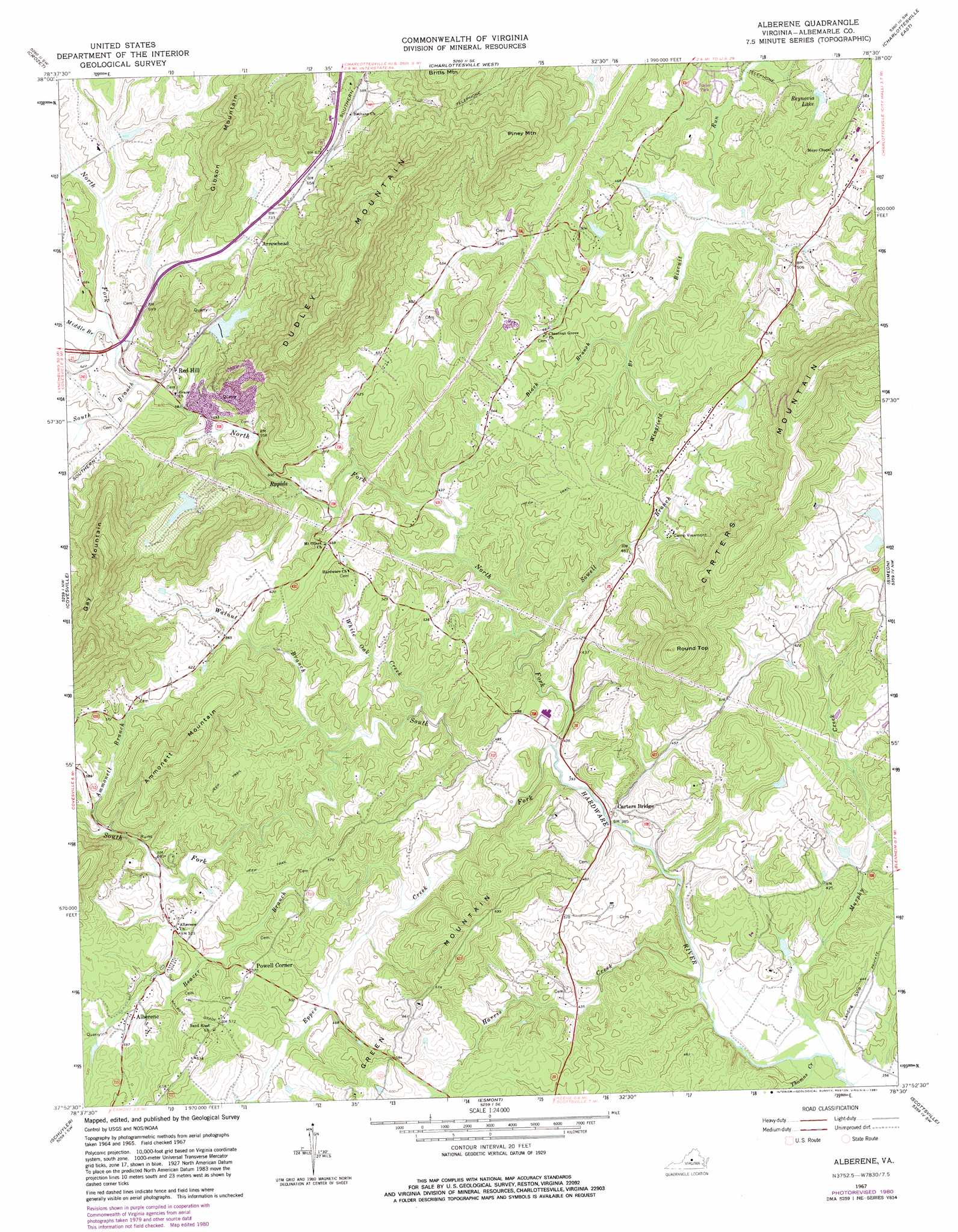
Alberene Topo Map Virginia
To zoom in, hover over the map of Alberene
USGS Topo Quad 37078h5 - 1:24,000 scale
| Topo Map Name: | Alberene |
| USGS Topo Quad ID: | 37078h5 |
| Print Size: | ca. 21 1/4" wide x 27" high |
| Southeast Coordinates: | 37.875° N latitude / 78.5° W longitude |
| Map Center Coordinates: | 37.9375° N latitude / 78.5625° W longitude |
| U.S. State: | VA |
| Filename: | o37078h5.jpg |
| Download Map JPG Image: | Alberene topo map 1:24,000 scale |
| Map Type: | Topographic |
| Topo Series: | 7.5´ |
| Map Scale: | 1:24,000 |
| Source of Map Images: | United States Geological Survey (USGS) |
| Alternate Map Versions: |
Alberene VA 1967, updated 1968 Download PDF Buy paper map Alberene VA 1967, updated 1981 Download PDF Buy paper map Alberene VA 1979, updated 1982 Download PDF Buy paper map Alberene VA 2010 Download PDF Buy paper map Alberene VA 2013 Download PDF Buy paper map Alberene VA 2016 Download PDF Buy paper map |
1:24,000 Topo Quads surrounding Alberene
Crimora |
Browns Cove |
Free Union |
Earlysville |
Barboursville |
Waynesboro East |
Crozet |
Charlottesville West |
Charlottesville East |
Keswick |
Greenfield |
Covesville |
Alberene |
Simeon |
Boyd Tavern |
Lovingston |
Schuyler |
Esmont |
Scottsville |
Palmyra |
Shipman |
Howardsville |
Glenmore |
Diana Mills |
Arvonia |
> Back to 37078e1 at 1:100,000 scale
> Back to 37078a1 at 1:250,000 scale
> Back to U.S. Topo Maps home
Alberene topo map: Gazetteer
Alberene: Airports
Albemarle Farms Heliport elevation 188m 616′Alberene: Dams
Blandemar Farm Dam elevation 215m 705′Red Hill Orchard Dam elevation 266m 872′
Reynovia Dam elevation 131m 429′
Superior Stone Company Dam elevation 211m 692′
Timber Lake Dam elevation 118m 387′
Alberene: Mines
Red Hill Quarry elevation 249m 816′Alberene: Parks
Walnut Creek Park elevation 187m 613′Alberene: Populated Places
Alberene elevation 159m 521′Arrowhead elevation 217m 711′
Marshall Manor elevation 205m 672′
Mill Creek elevation 151m 495′
Powell Corner elevation 176m 577′
Redland elevation 192m 629′
Southwood Estates Mobile Home Park elevation 140m 459′
Alberene: Reservoirs
Blandemar Farm Pond elevation 215m 705′Red Hill Orchard Lake elevation 266m 872′
Reynovia Lake elevation 131m 429′
Timberlake Pond elevation 118m 387′
Alberene: Streams
Ammonett Branch elevation 144m 472′Beaver Branch elevation 124m 406′
Black Branch elevation 140m 459′
Eppes Creek elevation 119m 390′
Harris Creek elevation 109m 357′
Middle Branch North Fork Hardware River elevation 177m 580′
Murphy Creek elevation 104m 341′
North Fork Hardware River elevation 116m 380′
South Branch North Fork Hardware River elevation 177m 580′
South Fork Hardware River elevation 117m 383′
Sowell Branch elevation 127m 416′
Thomas Creek elevation 110m 360′
Walnut Branch elevation 128m 419′
White Oak Creek elevation 131m 429′
Wingfield Branch elevation 140m 459′
Alberene: Summits
Ammonett Mountain elevation 291m 954′Dudley Mountain elevation 487m 1597′
Gay Mountain elevation 411m 1348′
Gibson Mountain elevation 391m 1282′
Piney Mountain elevation 399m 1309′
Round Top elevation 327m 1072′
Alberene digital topo map on disk
Buy this Alberene topo map showing relief, roads, GPS coordinates and other geographical features, as a high-resolution digital map file on DVD:
Western Virginia & Southern West Virginia
Buy digital topo maps: Western Virginia & Southern West Virginia