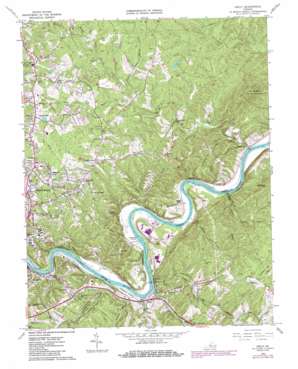
Kelly Topo Map Virginia
To zoom in, hover over the map of Kelly
USGS Topo Quad 37079d1 - 1:24,000 scale
| Topo Map Name: | Kelly |
| USGS Topo Quad ID: | 37079d1 |
| Print Size: | ca. 21 1/4" wide x 27" high |
| Southeast Coordinates: | 37.375° N latitude / 79° W longitude |
| Map Center Coordinates: | 37.4375° N latitude / 79.0625° W longitude |
| U.S. State: | VA |
| Filename: | o37079d1.jpg |
| Download Map JPG Image: | Kelly topo map 1:24,000 scale |
| Map Type: | Topographic |
| Topo Series: | 7.5´ |
| Map Scale: | 1:24,000 |
| Source of Map Images: | United States Geological Survey (USGS) |
| Alternate Map Versions: |
Kelly VA 1963, updated 1965 Download PDF Buy paper map Kelly VA 1963, updated 1971 Download PDF Buy paper map Kelly VA 1963, updated 1986 Download PDF Buy paper map Kelly VA 2010 Download PDF Buy paper map Kelly VA 2013 Download PDF Buy paper map Kelly VA 2016 Download PDF Buy paper map |
1:24,000 Topo Quads surrounding Kelly
> Back to 37079a1 at 1:100,000 scale
> Back to 37078a1 at 1:250,000 scale
> Back to U.S. Topo Maps home
Kelly topo map: Gazetteer
Kelly: Airports
Falwell Airport elevation 264m 866′Kelly: Bridges
Ninemile Bridge elevation 142m 465′Kelly: Dams
Wennings Dam elevation 231m 757′Kelly: Islands
Buzzard Islands elevation 143m 469′Feagans Island elevation 152m 498′
Kelly: Parks
Civitan Park elevation 191m 626′Kelly: Populated Places
Brightwell Mill elevation 175m 574′City Gomingo elevation 240m 787′
Colony elevation 229m 751′
Deacon (historical) elevation 151m 495′
Edgewood elevation 267m 875′
Galts Mill elevation 154m 505′
Glenwood elevation 261m 856′
Great Oaks elevation 253m 830′
Holiday Acres elevation 263m 862′
Joshua Falls elevation 146m 479′
Kelly elevation 158m 518′
Lakeview elevation 225m 738′
Lamont Acres elevation 228m 748′
Madison Heights elevation 233m 764′
Magruder Hills elevation 266m 872′
Martins Shop elevation 254m 833′
Martins Store elevation 260m 853′
Melwood Manor elevation 248m 813′
Montrose Heights elevation 254m 833′
Mount Athos (historical) elevation 230m 754′
Old Stage Run elevation 253m 830′
Oxford Furnace elevation 169m 554′
Prices Store elevation 279m 915′
Sandusky Park elevation 259m 849′
Sandy Bottom elevation 261m 856′
Six Mile elevation 161m 528′
Viking Fiord elevation 260m 853′
West Bethel elevation 260m 853′
Williamsburg Manor elevation 247m 810′
Wright Shop elevation 262m 859′
Kelly: Reservoirs
Schrader Lake elevation 208m 682′Woody Lake elevation 237m 777′
Kelly: Streams
Archer Creek elevation 146m 479′Beaver Creek elevation 146m 479′
Beck Creek elevation 136m 446′
Fishing Creek elevation 151m 495′
Joes Branch elevation 158m 518′
Joshua Creek elevation 135m 442′
Juniper Creek elevation 143m 469′
Little Beaver Creek elevation 155m 508′
Little Opossum Creek elevation 148m 485′
Middle Fork Stovall Creek elevation 193m 633′
North Fork Stovall Creek elevation 198m 649′
Opossum Creek elevation 147m 482′
Slippery Branch elevation 142m 465′
South Fork Stovall Creek elevation 195m 639′
Stovall Creek elevation 181m 593′
Williams Run elevation 148m 485′
Kelly: Summits
Chestnut Mountain elevation 325m 1066′Galts Mill Mountain elevation 287m 941′
Mount Athos elevation 269m 882′
Round Mountain elevation 349m 1145′
Kelly digital topo map on disk
Buy this Kelly topo map showing relief, roads, GPS coordinates and other geographical features, as a high-resolution digital map file on DVD:
Western Virginia & Southern West Virginia
Buy digital topo maps: Western Virginia & Southern West Virginia


