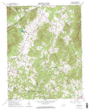
Sedalia Topo Map Virginia
To zoom in, hover over the map of Sedalia
USGS Topo Quad 37079d4 - 1:24,000 scale
| Topo Map Name: | Sedalia |
| USGS Topo Quad ID: | 37079d4 |
| Print Size: | ca. 21 1/4" wide x 27" high |
| Southeast Coordinates: | 37.375° N latitude / 79.375° W longitude |
| Map Center Coordinates: | 37.4375° N latitude / 79.4375° W longitude |
| U.S. State: | VA |
| Filename: | o37079d4.jpg |
| Download Map JPG Image: | Sedalia topo map 1:24,000 scale |
| Map Type: | Topographic |
| Topo Series: | 7.5´ |
| Map Scale: | 1:24,000 |
| Source of Map Images: | United States Geological Survey (USGS) |
| Alternate Map Versions: |
Sedalia VA 1965, updated 1968 Download PDF Buy paper map Sedalia VA 1965, updated 1968 Download PDF Buy paper map Sedalia VA 2011 Download PDF Buy paper map Sedalia VA 2013 Download PDF Buy paper map Sedalia VA 2016 Download PDF Buy paper map |
| FStopo: | US Forest Service topo Sedalia is available: Download FStopo PDF Download FStopo TIF |
1:24,000 Topo Quads surrounding Sedalia
> Back to 37079a1 at 1:100,000 scale
> Back to 37078a1 at 1:250,000 scale
> Back to U.S. Topo Maps home
Sedalia topo map: Gazetteer
Sedalia: Dams
Bedford Lake Dam elevation 308m 1010′Kyanite Mine Waste Dam Number Two elevation 475m 1558′
Sedalia: Parks
Bedford County Park (historical) elevation 448m 1469′Sedalia: Populated Places
Charlemont elevation 300m 984′Cifax elevation 286m 938′
Coltons Mill elevation 292m 958′
Curtis elevation 329m 1079′
Otterville elevation 290m 951′
Sedalia elevation 311m 1020′
Sedalia: Reservoirs
Bedford Lake elevation 308m 1010′Sedalia: Streams
Boyles Branch elevation 223m 731′Gunstock Creek elevation 329m 1079′
Hurricane Creek elevation 237m 777′
Lillies Branch elevation 245m 803′
Nelson Creek elevation 256m 839′
North Otter Creek elevation 210m 688′
Oslin Creek elevation 212m 695′
Overstreet Creek elevation 323m 1059′
Persimmon Creek elevation 281m 921′
Roaring Run elevation 202m 662′
Sycamore Creek elevation 205m 672′
Sedalia: Summits
Flint Stone Mountain elevation 531m 1742′Grassy Mountain elevation 498m 1633′
Hurricane Mountain elevation 481m 1578′
Jackson Mountain elevation 519m 1702′
Lone Pine Mountain elevation 424m 1391′
No Business Mountain elevation 837m 2746′
Squirrel Mountain elevation 505m 1656′
Sedalia digital topo map on disk
Buy this Sedalia topo map showing relief, roads, GPS coordinates and other geographical features, as a high-resolution digital map file on DVD:
Western Virginia & Southern West Virginia
Buy digital topo maps: Western Virginia & Southern West Virginia


