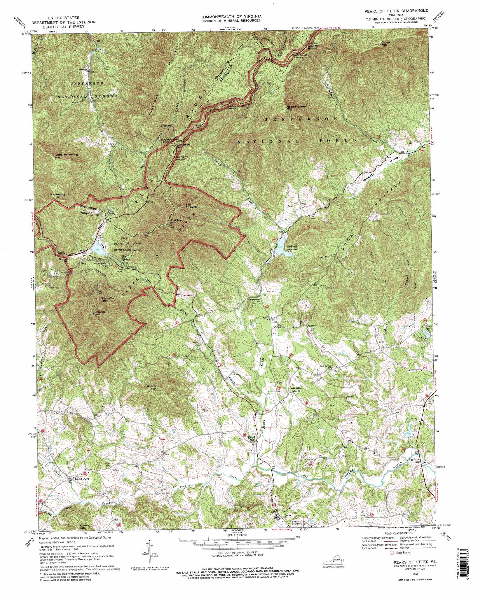
Peaks Of Otter Topo Map Virginia
To zoom in, hover over the map of Peaks Of Otter
USGS Topo Quad 37079d5 - 1:24,000 scale
| Topo Map Name: | Peaks Of Otter |
| USGS Topo Quad ID: | 37079d5 |
| Print Size: | ca. 21 1/4" wide x 27" high |
| Southeast Coordinates: | 37.375° N latitude / 79.5° W longitude |
| Map Center Coordinates: | 37.4375° N latitude / 79.5625° W longitude |
| U.S. State: | VA |
| Filename: | o37079d5.jpg |
| Download Map JPG Image: | Peaks Of Otter topo map 1:24,000 scale |
| Map Type: | Topographic |
| Topo Series: | 7.5´ |
| Map Scale: | 1:24,000 |
| Source of Map Images: | United States Geological Survey (USGS) |
| Alternate Map Versions: |
Peaks of Otter VA 1967, updated 1970 Download PDF Buy paper map Peaks Of Otter VA 1967, updated 1988 Download PDF Buy paper map Peaks Of Otter VA 1967, updated 1988 Download PDF Buy paper map Peaks of Otter VA 1977, updated 1983 Download PDF Buy paper map Peaks of Otter VA 2011 Download PDF Buy paper map Peaks of Otter VA 2013 Download PDF Buy paper map Peaks of Otter VA 2016 Download PDF Buy paper map |
| FStopo: | US Forest Service topo Peaks of Otter is available: Download FStopo PDF Download FStopo TIF |
1:24,000 Topo Quads surrounding Peaks Of Otter
Eagle Rock |
Sugarloaf Mountain |
Natural Bridge |
Glasgow |
Buena Vista |
Salisbury |
Buchanan |
Arnold Valley |
Snowden |
Big Island |
Villamont |
Montvale |
Peaks Of Otter |
Sedalia |
Boonsboro |
Stewartsville |
Irving |
Bedford |
Goode |
Forest |
Hardy |
Goodview |
Moneta |
Huddleston |
Lynch Station |
> Back to 37079a1 at 1:100,000 scale
> Back to 37078a1 at 1:250,000 scale
> Back to U.S. Topo Maps home
Peaks Of Otter topo map: Gazetteer
Peaks Of Otter: Dams
Bedford Dam elevation 415m 1361′Old Bedford City Dam elevation 398m 1305′
Peaks of Otter Dam elevation 766m 2513′
Spring Hill Lake Dam elevation 239m 784′
Peaks Of Otter: Gaps
Wilkerson Gap elevation 776m 2545′Peaks Of Otter: Parks
Peaks of Otter Recreation Area elevation 770m 2526′Peaks Of Otter: Pillars
The Pinnacle elevation 1109m 3638′Peaks Of Otter: Populated Places
Big Otter Mill elevation 233m 764′Kelso Mill elevation 270m 885′
Old Mill elevation 231m 757′
Peaksville elevation 285m 935′
Penicks Mill elevation 291m 954′
Peaks Of Otter: Reservoirs
Abbott Lake elevation 755m 2477′Bedford Reservoir elevation 415m 1361′
Peaks of Otter Lake elevation 766m 2513′
Spring Hill Lake elevation 239m 784′
Peaks Of Otter: Springs
Big Spring elevation 737m 2417′Peaks Of Otter: Streams
Camp Creek elevation 285m 935′Fallingwater Creek elevation 479m 1571′
Little Stony Creek elevation 280m 918′
Reba Creek elevation 303m 994′
Sheep Creek elevation 262m 859′
Stony Creek elevation 261m 856′
Peaks Of Otter: Summits
Buzzards Roost elevation 1074m 3523′Chesnut Mountain elevation 942m 3090′
Flat Top Mountain elevation 1211m 3973′
Floyd Mountain elevation 1064m 3490′
Harkening Hill elevation 1022m 3353′
Headforemost Mountain elevation 1131m 3710′
Little Harkening Hill elevation 901m 2956′
Onion Mountain elevation 1157m 3795′
Peaks of Otter elevation 910m 2985′
Sharp Top Mountain elevation 1167m 3828′
Sharps Mountain elevation 540m 1771′
Suck Mountain elevation 664m 2178′
Sunset Hill elevation 806m 2644′
Peaks Of Otter: Trails
Fallingwater Trail elevation 744m 2440′Flat Top Mountain Trail elevation 1208m 3963′
Peaks Of Otter: Valleys
Wheats Valley elevation 392m 1286′Peaks Of Otter digital topo map on disk
Buy this Peaks Of Otter topo map showing relief, roads, GPS coordinates and other geographical features, as a high-resolution digital map file on DVD:
Western Virginia & Southern West Virginia
Buy digital topo maps: Western Virginia & Southern West Virginia