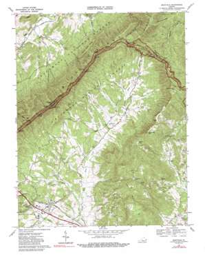
Montvale Topo Map Virginia
To zoom in, hover over the map of Montvale
USGS Topo Quad 37079d6 - 1:24,000 scale
| Topo Map Name: | Montvale |
| USGS Topo Quad ID: | 37079d6 |
| Print Size: | ca. 21 1/4" wide x 27" high |
| Southeast Coordinates: | 37.375° N latitude / 79.625° W longitude |
| Map Center Coordinates: | 37.4375° N latitude / 79.6875° W longitude |
| U.S. State: | VA |
| Filename: | o37079d6.jpg |
| Download Map JPG Image: | Montvale topo map 1:24,000 scale |
| Map Type: | Topographic |
| Topo Series: | 7.5´ |
| Map Scale: | 1:24,000 |
| Source of Map Images: | United States Geological Survey (USGS) |
| Alternate Map Versions: |
Montvale VA 1967, updated 1970 Download PDF Buy paper map Montvale VA 1967, updated 1981 Download PDF Buy paper map Montvale VA 1967, updated 1989 Download PDF Buy paper map Montvale VA 2011 Download PDF Buy paper map Montvale VA 2013 Download PDF Buy paper map Montvale VA 2016 Download PDF Buy paper map |
| FStopo: | US Forest Service topo Montvale is available: Download FStopo PDF Download FStopo TIF |
1:24,000 Topo Quads surrounding Montvale
> Back to 37079a1 at 1:100,000 scale
> Back to 37078a1 at 1:250,000 scale
> Back to U.S. Topo Maps home
Montvale topo map: Gazetteer
Montvale: Airports
Bufords Airport (historical) elevation 292m 958′Montvale: Crossings
Interchange 162 elevation 659m 2162′Montvale: Gaps
Bearwallow Gap elevation 688m 2257′Bobblets Gap elevation 644m 2112′
Cobbs Gap elevation 568m 1863′
Murrill Gap elevation 516m 1692′
Powell Gap elevation 570m 1870′
Montvale: Parks
Montvale Wayside elevation 302m 990′Montvale: Populated Places
Montvale elevation 295m 967′Pico elevation 318m 1043′
Reba elevation 341m 1118′
Montvale: Ridges
Chair Rock Ridge elevation 630m 2066′McFalls Ridge elevation 615m 2017′
Montvale: Streams
Back Creek elevation 289m 948′Day Creek elevation 275m 902′
Ellis Run elevation 278m 912′
Glove Creek elevation 287m 941′
Hemp Mill Branch elevation 310m 1017′
McCoglin Branch elevation 412m 1351′
Mill Creek elevation 282m 925′
Montvale: Summits
Campbells Mountain elevation 726m 2381′Cove Mountain elevation 818m 2683′
Harveys Knob elevation 809m 2654′
McFalls Mountain elevation 842m 2762′
Sunset Hill elevation 623m 2043′
Taylors Mountain elevation 776m 2545′
Montvale: Trails
Hammond Hollow Trail elevation 467m 1532′Spec Mines Trail elevation 604m 1981′
Montvale: Valleys
Chair Rock Hollow elevation 399m 1309′Hanging Rock Hollow elevation 348m 1141′
Tar Hollow elevation 376m 1233′
Montvale digital topo map on disk
Buy this Montvale topo map showing relief, roads, GPS coordinates and other geographical features, as a high-resolution digital map file on DVD:
Western Virginia & Southern West Virginia
Buy digital topo maps: Western Virginia & Southern West Virginia


