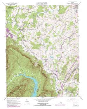
Daleville Topo Map Virginia
To zoom in, hover over the map of Daleville
USGS Topo Quad 37079d8 - 1:24,000 scale
| Topo Map Name: | Daleville |
| USGS Topo Quad ID: | 37079d8 |
| Print Size: | ca. 21 1/4" wide x 27" high |
| Southeast Coordinates: | 37.375° N latitude / 79.875° W longitude |
| Map Center Coordinates: | 37.4375° N latitude / 79.9375° W longitude |
| U.S. State: | VA |
| Filename: | o37079d8.jpg |
| Download Map JPG Image: | Daleville topo map 1:24,000 scale |
| Map Type: | Topographic |
| Topo Series: | 7.5´ |
| Map Scale: | 1:24,000 |
| Source of Map Images: | United States Geological Survey (USGS) |
| Alternate Map Versions: |
Daleville VA 1963, updated 1965 Download PDF Buy paper map Daleville VA 1963, updated 1973 Download PDF Buy paper map Daleville VA 1963, updated 1978 Download PDF Buy paper map Daleville VA 1963, updated 1978 Download PDF Buy paper map Daleville VA 1977, updated 1983 Download PDF Buy paper map Daleville VA 2011 Download PDF Buy paper map Daleville VA 2013 Download PDF Buy paper map Daleville VA 2016 Download PDF Buy paper map |
| FStopo: | US Forest Service topo Daleville is available: Download FStopo PDF Download FStopo TIF |
1:24,000 Topo Quads surrounding Daleville
> Back to 37079a1 at 1:100,000 scale
> Back to 37078a1 at 1:250,000 scale
> Back to U.S. Topo Maps home
Daleville topo map: Gazetteer
Daleville: Airports
Barrows Airport elevation 333m 1092′Daleville: Crossings
Interchange 150 elevation 361m 1184′Daleville: Dams
Orchard Lake Dam elevation 397m 1302′Daleville: Parks
Fincastle Historic District elevation 379m 1243′Daleville: Populated Places
Amsterdam elevation 415m 1361′Cave Alum Springs (historical) elevation 377m 1236′
Daleville elevation 396m 1299′
Fincastle elevation 378m 1240′
Glebe Mills elevation 386m 1266′
Haymakertown elevation 383m 1256′
Lone Star elevation 426m 1397′
Mount Union elevation 432m 1417′
Trinity elevation 425m 1394′
Daleville: Reservoirs
Orchard Lake elevation 397m 1302′Daleville: Streams
Angell Branch elevation 356m 1167′Buffalo Creek elevation 352m 1154′
Lees Creek elevation 339m 1112′
Lemons Run elevation 365m 1197′
Rocky Branch elevation 355m 1164′
Rocky Branch elevation 360m 1181′
Rulman Branch elevation 380m 1246′
Sawmill Branch elevation 356m 1167′
Stone Coal Creek elevation 378m 1240′
Daleville: Summits
Brushy Mountain elevation 726m 2381′Tinker Mountain elevation 888m 2913′
Daleville digital topo map on disk
Buy this Daleville topo map showing relief, roads, GPS coordinates and other geographical features, as a high-resolution digital map file on DVD:
Western Virginia & Southern West Virginia
Buy digital topo maps: Western Virginia & Southern West Virginia


