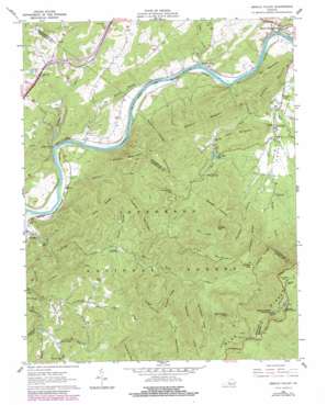
Arnold Valley Topo Map Virginia
To zoom in, hover over the map of Arnold Valley
USGS Topo Quad 37079e5 - 1:24,000 scale
| Topo Map Name: | Arnold Valley |
| USGS Topo Quad ID: | 37079e5 |
| Print Size: | ca. 21 1/4" wide x 27" high |
| Southeast Coordinates: | 37.5° N latitude / 79.5° W longitude |
| Map Center Coordinates: | 37.5625° N latitude / 79.5625° W longitude |
| U.S. State: | VA |
| Filename: | o37079e5.jpg |
| Download Map JPG Image: | Arnold Valley topo map 1:24,000 scale |
| Map Type: | Topographic |
| Topo Series: | 7.5´ |
| Map Scale: | 1:24,000 |
| Source of Map Images: | United States Geological Survey (USGS) |
| Alternate Map Versions: |
Arnold Valley VA 1961, updated 1963 Download PDF Buy paper map Arnold Valley VA 1961, updated 1979 Download PDF Buy paper map Arnold Valley VA 1961, updated 1979 Download PDF Buy paper map Arnold Valley VA 1999, updated 2000 Download PDF Buy paper map Arnold Valley VA 2011 Download PDF Buy paper map Arnold Valley VA 2013 Download PDF Buy paper map Arnold Valley VA 2016 Download PDF Buy paper map |
| FStopo: | US Forest Service topo Arnold Valley is available: Download FStopo PDF Download FStopo TIF |
1:24,000 Topo Quads surrounding Arnold Valley
> Back to 37079e1 at 1:100,000 scale
> Back to 37078a1 at 1:250,000 scale
> Back to U.S. Topo Maps home
Arnold Valley topo map: Gazetteer
Arnold Valley: Areas
Sugarland elevation 878m 2880′Sunset Field elevation 1049m 3441′
Arnold Valley: Dams
Cave Mountain Dam elevation 358m 1174′Arnold Valley: Falls
Apple Orchard Falls elevation 811m 2660′Arnold Valley: Gaps
Hoop Pole Gap elevation 513m 1683′Parkers Gap elevation 790m 2591′
Arnold Valley: Populated Places
Alpine elevation 240m 787′Arcadia elevation 254m 833′
Fork Mountain elevation 620m 2034′
Gilmore Mills elevation 238m 780′
Harvey elevation 397m 1302′
Munford elevation 341m 1118′
Natural Bridge Station elevation 233m 764′
Rocky Point elevation 242m 793′
Solitude elevation 240m 787′
Arnold Valley: Reservoirs
Cave Mountain Lake elevation 358m 1174′Arnold Valley: Ridges
Backbone Ridge elevation 839m 2752′Bryant Ridge elevation 697m 2286′
Buzzard Ridge elevation 697m 2286′
Drummond Hill elevation 526m 1725′
Hopper Ridge elevation 854m 2801′
Pine Ridge elevation 662m 2171′
Snakeden Ridge elevation 688m 2257′
Southside Ridge elevation 432m 1417′
Arnold Valley: Streams
Back Run elevation 230m 754′Big Hollow Branch elevation 219m 718′
Cedar Creek elevation 220m 721′
Chestnut Run elevation 351m 1151′
Cornelius Creek elevation 449m 1473′
Cove Creek elevation 308m 1010′
Crawford Creek elevation 225m 738′
East Fork Elk Creek elevation 246m 807′
Hopper Creek elevation 293m 961′
Little Hellgate Creek elevation 231m 757′
McFalls Creek elevation 338m 1108′
North Creek elevation 266m 872′
Roaring Run elevation 226m 741′
Sprouts Run elevation 231m 757′
Yellowstone Branch elevation 339m 1112′
Arnold Valley: Summits
Apple Orchard Mountain elevation 1282m 4206′Blue Spring Hill elevation 403m 1322′
Cave Mountain elevation 500m 1640′
Chestnut Mountain elevation 807m 2647′
Furnace Mountain elevation 472m 1548′
Lone Field Hill elevation 574m 1883′
Mill Mountain elevation 401m 1315′
Pine Mountain elevation 839m 2752′
Skillern Mountain elevation 515m 1689′
Thomas Mountain elevation 680m 2230′
Thunder Hill elevation 1221m 4005′
Wildcat Mountain elevation 819m 2687′
Wilson Mountain elevation 623m 2043′
Arnold Valley: Trails
Cove Mountain Trail elevation 440m 1443′Wildcat Trail elevation 485m 1591′
Arnold Valley: Valleys
Bear Hollow elevation 547m 1794′Colon Hollow elevation 343m 1125′
Gilmore Hollow elevation 231m 757′
Oppossum Hollow elevation 326m 1069′
Arnold Valley digital topo map on disk
Buy this Arnold Valley topo map showing relief, roads, GPS coordinates and other geographical features, as a high-resolution digital map file on DVD:
Western Virginia & Southern West Virginia
Buy digital topo maps: Western Virginia & Southern West Virginia


