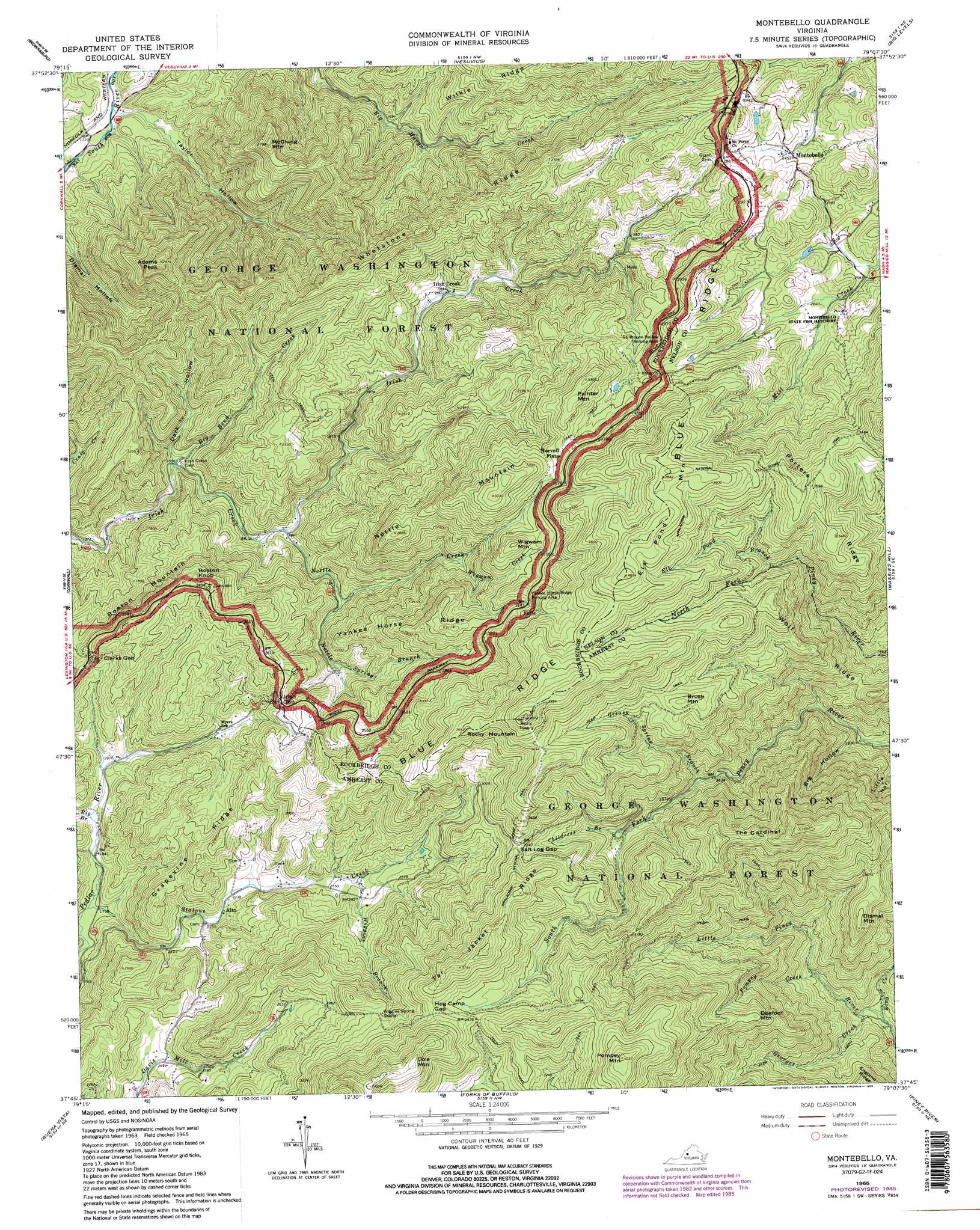
Montebello Topo Map Virginia
To zoom in, hover over the map of Montebello
USGS Topo Quad 37079g2 - 1:24,000 scale
| Topo Map Name: | Montebello |
| USGS Topo Quad ID: | 37079g2 |
| Print Size: | ca. 21 1/4" wide x 27" high |
| Southeast Coordinates: | 37.75° N latitude / 79.125° W longitude |
| Map Center Coordinates: | 37.8125° N latitude / 79.1875° W longitude |
| U.S. State: | VA |
| Filename: | o37079g2.jpg |
| Download Map JPG Image: | Montebello topo map 1:24,000 scale |
| Map Type: | Topographic |
| Topo Series: | 7.5´ |
| Map Scale: | 1:24,000 |
| Source of Map Images: | United States Geological Survey (USGS) |
| Alternate Map Versions: |
Montebello VA 1965, updated 1967 Download PDF Buy paper map Montebello VA 1965, updated 1977 Download PDF Buy paper map Montebello VA 1965, updated 1986 Download PDF Buy paper map Montebello VA 1965, updated 1986 Download PDF Buy paper map Montebello VA 1999, updated 2000 Download PDF Buy paper map Montebello VA 2011 Download PDF Buy paper map Montebello VA 2013 Download PDF Buy paper map Montebello VA 2016 Download PDF Buy paper map |
| FStopo: | US Forest Service topo Montebello is available: Download FStopo PDF Download FStopo TIF |
1:24,000 Topo Quads surrounding Montebello
Craigsville |
Augusta Springs |
Greenville |
Stuarts Draft |
Waynesboro West |
Goshen |
Brownsburg |
Vesuvius |
Big Levels |
Sherando |
Lexington |
Cornwall |
Montebello |
Massies Mill |
Horseshoe Mountain |
Glasgow |
Buena Vista |
Forks Of Buffalo |
Piney River |
Arrington |
Snowden |
Big Island |
Tobacco Row Mountain |
Amherst |
Buffalo Ridge |
> Back to 37079e1 at 1:100,000 scale
> Back to 37078a1 at 1:250,000 scale
> Back to U.S. Topo Maps home
Montebello topo map: Gazetteer
Montebello: Falls
Statons Creek Falls elevation 555m 1820′Montebello: Gaps
Clarks Gap elevation 658m 2158′Hog Camp Gap elevation 1066m 3497′
Irish Gap elevation 691m 2267′
Salt Log Gap elevation 986m 3234′
Montebello: Mines
Irish Creek Mine elevation 731m 2398′Montebello: Parks
Mount Pleasant Special Management Area elevation 1048m 3438′Montebello: Populated Places
Alto elevation 680m 2230′Irish Creek elevation 609m 1998′
Montebello elevation 838m 2749′
Montebello: Ridges
Grapevine Ridge elevation 807m 2647′Porters Ridge elevation 1049m 3441′
Tar Jacket Ridge elevation 1150m 3772′
Whetstone Ridge elevation 863m 2831′
Wilkie Ridge elevation 799m 2621′
Wolf Ridge elevation 917m 3008′
Yankee Horse Ridge elevation 911m 2988′
Montebello: Springs
Lovingston Springs elevation 1136m 3727′Twin Springs elevation 1159m 3802′
Montebello: Streams
Big Bend Creek elevation 458m 1502′Big Branch elevation 558m 1830′
Childress Branch elevation 805m 2641′
Elk Pond Branch elevation 913m 2995′
Georges Creek elevation 484m 1587′
Greasy Spring Branch elevation 746m 2447′
King Creek elevation 475m 1558′
Mill Creek elevation 782m 2565′
Nettle Creek elevation 498m 1633′
Nettle Spring Branch elevation 545m 1788′
Pompey Creek elevation 541m 1774′
Statons Creek elevation 547m 1794′
Wheelers Run elevation 546m 1791′
Wiggins Branch elevation 723m 2372′
Wigwam Creek elevation 704m 2309′
Montebello: Summits
Adams Peak elevation 904m 2965′Boston Knob elevation 781m 2562′
Boston Mountain elevation 781m 2562′
Brush Mountain elevation 1049m 3441′
Cole Mountain elevation 1197m 3927′
Dismal Mountain elevation 854m 2801′
Doefoot Mountain elevation 926m 3038′
Elk Pond Mountain elevation 1226m 4022′
McClung Mountain elevation 843m 2765′
Nettle Mountain elevation 1014m 3326′
Painter Mountain elevation 1001m 3284′
Rocky Mountain elevation 1109m 3638′
The Cardinal elevation 1023m 3356′
Wigwam Mountain elevation 974m 3195′
Montebello: Valleys
Big Hollow elevation 543m 1781′Dark Hollow elevation 458m 1502′
Taylor Hollow elevation 376m 1233′
Montebello digital topo map on disk
Buy this Montebello topo map showing relief, roads, GPS coordinates and other geographical features, as a high-resolution digital map file on DVD:
Western Virginia & Southern West Virginia
Buy digital topo maps: Western Virginia & Southern West Virginia