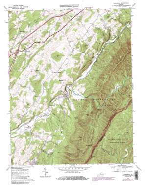
Cornwall Topo Map Virginia
To zoom in, hover over the map of Cornwall
USGS Topo Quad 37079g3 - 1:24,000 scale
| Topo Map Name: | Cornwall |
| USGS Topo Quad ID: | 37079g3 |
| Print Size: | ca. 21 1/4" wide x 27" high |
| Southeast Coordinates: | 37.75° N latitude / 79.25° W longitude |
| Map Center Coordinates: | 37.8125° N latitude / 79.3125° W longitude |
| U.S. State: | VA |
| Filename: | o37079g3.jpg |
| Download Map JPG Image: | Cornwall topo map 1:24,000 scale |
| Map Type: | Topographic |
| Topo Series: | 7.5´ |
| Map Scale: | 1:24,000 |
| Source of Map Images: | United States Geological Survey (USGS) |
| Alternate Map Versions: |
Cornwall VA 1967, updated 1969 Download PDF Buy paper map Cornwall VA 1967, updated 1984 Download PDF Buy paper map Cornwall VA 1967, updated 1986 Download PDF Buy paper map Cornwall VA 2011 Download PDF Buy paper map Cornwall VA 2013 Download PDF Buy paper map Cornwall VA 2016 Download PDF Buy paper map |
| FStopo: | US Forest Service topo Cornwall is available: Download FStopo PDF Download FStopo TIF |
1:24,000 Topo Quads surrounding Cornwall
> Back to 37079e1 at 1:100,000 scale
> Back to 37078a1 at 1:250,000 scale
> Back to U.S. Topo Maps home
Cornwall topo map: Gazetteer
Cornwall: Crossings
Interchange 195 elevation 390m 1279′Cornwall: Gaps
Chestnut Sag elevation 745m 2444′Whites Gap elevation 788m 2585′
Cornwall: Populated Places
Blacksburg elevation 438m 1437′Cornwall elevation 305m 1000′
Crossroads Store elevation 413m 1354′
Donaldsburg elevation 462m 1515′
Marlbrook elevation 367m 1204′
Midvale elevation 333m 1092′
Mountain View elevation 306m 1003′
Riverside elevation 289m 948′
Stewardsburg elevation 267m 875′
Timber Ridge elevation 433m 1420′
Cornwall: Ridges
Roundtop Ridge elevation 399m 1309′Timber Ridge elevation 507m 1663′
Cornwall: Streams
Craig Creek elevation 406m 1332′Falling Run elevation 347m 1138′
Irish Creek elevation 306m 1003′
Marl Creek elevation 274m 898′
Marlbrook Creek elevation 363m 1190′
Mill Branch elevation 385m 1263′
Nicholson Run elevation 504m 1653′
Rock Branch elevation 365m 1197′
Sheep Creek elevation 291m 954′
Stony Run elevation 293m 961′
Whites Run elevation 305m 1000′
Whitesides Run elevation 341m 1118′
Cornwall: Summits
Buck Hill elevation 507m 1663′Canaan Hill elevation 544m 1784′
Chimney Rock Mountain elevation 741m 2431′
Coates Mountain elevation 769m 2522′
Deckers Hill elevation 390m 1279′
Henry Hill elevation 536m 1758′
McClure Peak elevation 828m 2716′
Mount Atlas elevation 569m 1866′
Paxton Hill elevation 420m 1377′
Prospect Hills elevation 464m 1522′
Round Hill elevation 560m 1837′
South Mountain elevation 851m 2791′
Whites Peak elevation 881m 2890′
Cornwall: Valleys
Big Dark Hollow elevation 400m 1312′Cherry Orchard Hollow elevation 300m 984′
Dismal Hollow elevation 359m 1177′
Cornwall digital topo map on disk
Buy this Cornwall topo map showing relief, roads, GPS coordinates and other geographical features, as a high-resolution digital map file on DVD:
Western Virginia & Southern West Virginia
Buy digital topo maps: Western Virginia & Southern West Virginia


