Longdale Furnace Topo Map Virginia
To zoom in, hover over the map of Longdale Furnace
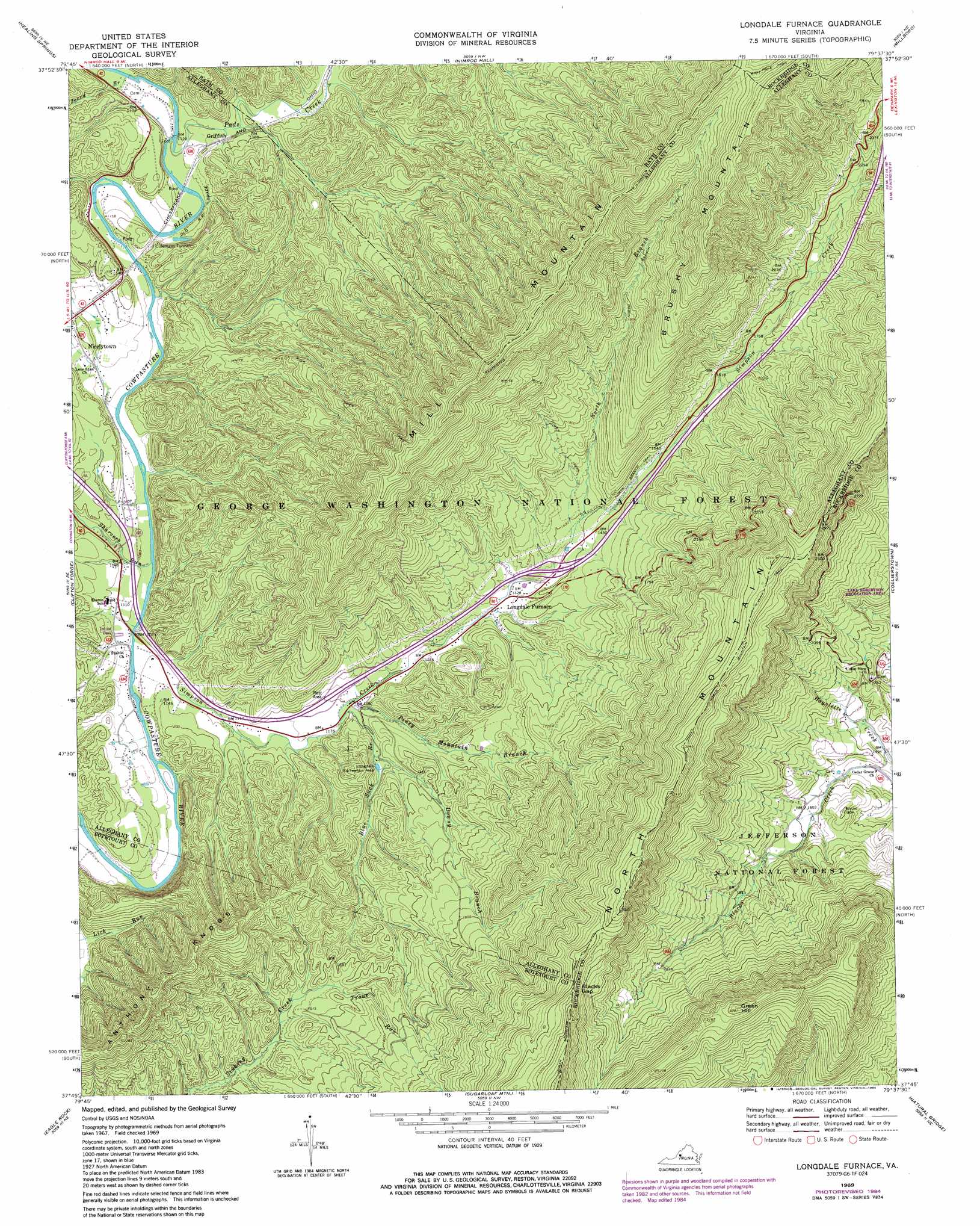
USGS Topo Quad 37079g6 - 1:24,000 scale
| Topo Map Name: | Longdale Furnace |
| USGS Topo Quad ID: | 37079g6 |
| Print Size: | ca. 21 1/4" wide x 27" high |
| Southeast Coordinates: | 37.75° N latitude / 79.625° W longitude |
| Map Center Coordinates: | 37.8125° N latitude / 79.6875° W longitude |
| U.S. State: | VA |
| Filename: | o37079g6.jpg |
| Download Map JPG Image: | Longdale Furnace topo map 1:24,000 scale |
| Map Type: | Topographic |
| Topo Series: | 7.5´ |
| Map Scale: | 1:24,000 |
| Source of Map Images: | United States Geological Survey (USGS) |
| Alternate Map Versions: |
Longdale Furnace VA 1969, updated 1971 Download PDF Buy paper map Longdale Furnace VA 1969, updated 1978 Download PDF Buy paper map Longdale Furnace VA 1969, updated 1984 Download PDF Buy paper map Longdale Furnace VA 2011 Download PDF Buy paper map Longdale Furnace VA 2013 Download PDF Buy paper map Longdale Furnace VA 2016 Download PDF Buy paper map |
| FStopo: | US Forest Service topo Longdale Furnace is available: Download FStopo PDF Download FStopo TIF |
1:24,000 Topo Quads surrounding Longdale Furnace
Mountain Grove |
Warm Springs |
Bath Alum |
Green Valley |
Craigsville |
Falling Spring |
Healing Springs |
Nimrod Hall |
Millboro |
Goshen |
Covington |
Clifton Forge |
Longdale Furnace |
Collierstown |
Lexington |
Strom |
Eagle Rock |
Sugarloaf Mountain |
Natural Bridge |
Glasgow |
Oriskany |
Salisbury |
Buchanan |
Arnold Valley |
Snowden |
> Back to 37079e1 at 1:100,000 scale
> Back to 37078a1 at 1:250,000 scale
> Back to U.S. Topo Maps home
Longdale Furnace topo map: Gazetteer
Longdale Furnace: Crossings
Interchange 35 elevation 410m 1345′Longdale Furnace: Gaps
Blacks Gap elevation 917m 3008′Rich Hole elevation 972m 3188′
Longdale Furnace: Parks
Longdale Recreation Area elevation 384m 1259′Longdale Furnace: Populated Places
Griffith elevation 356m 1167′Longdale Furnace elevation 394m 1292′
Nicelytown elevation 351m 1151′
Longdale Furnace: Streams
Blue Suck Branch elevation 354m 1161′Downy Branch elevation 375m 1230′
Jerry Branch elevation 343m 1125′
North Branch Simpson Creek elevation 425m 1394′
Pads Creek elevation 338m 1108′
Piney Mountain Branch elevation 359m 1177′
Sharvers Run elevation 320m 1049′
Simpson Creek elevation 329m 1079′
Trout Run elevation 442m 1450′
Longdale Furnace: Summits
Anthony Knobs elevation 731m 2398′Brushy Mountain elevation 1088m 3569′
Green Hill elevation 997m 3270′
Longdale Furnace: Trails
North Branch Trail elevation 727m 2385′North Mountain Trail elevation 940m 3083′
Rich Hole Trail elevation 846m 2775′
White Rock Tower Trail elevation 586m 1922′
Longdale Furnace: Tunnels
Colemans Tunnel elevation 378m 1240′Longdale Furnace digital topo map on disk
Buy this Longdale Furnace topo map showing relief, roads, GPS coordinates and other geographical features, as a high-resolution digital map file on DVD:
Western Virginia & Southern West Virginia
Buy digital topo maps: Western Virginia & Southern West Virginia