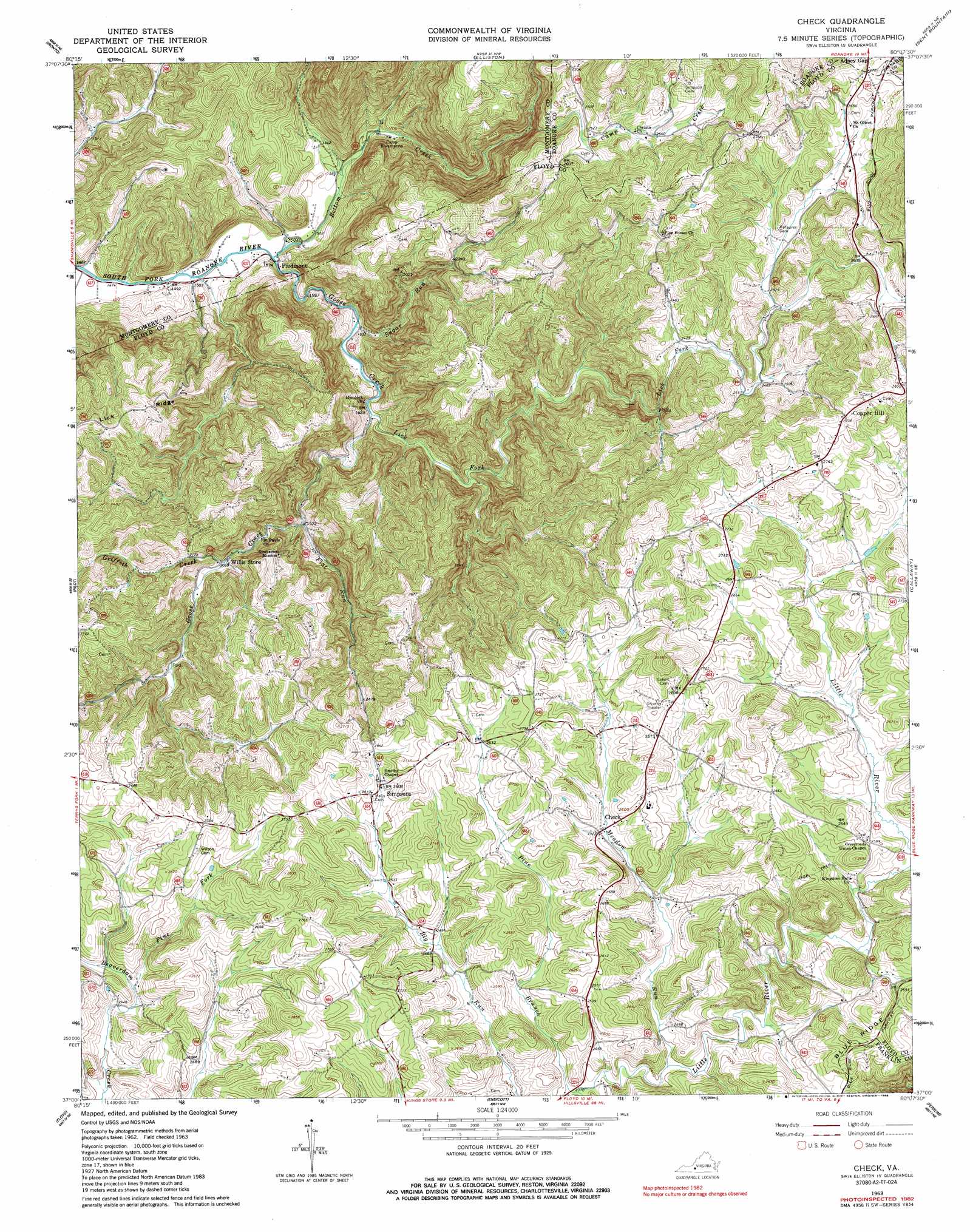
Check Topo Map Virginia
To zoom in, hover over the map of Check
USGS Topo Quad 37080a2 - 1:24,000 scale
| Topo Map Name: | Check |
| USGS Topo Quad ID: | 37080a2 |
| Print Size: | ca. 21 1/4" wide x 27" high |
| Southeast Coordinates: | 37° N latitude / 80.125° W longitude |
| Map Center Coordinates: | 37.0625° N latitude / 80.1875° W longitude |
| U.S. State: | VA |
| Filename: | o37080a2.jpg |
| Download Map JPG Image: | Check topo map 1:24,000 scale |
| Map Type: | Topographic |
| Topo Series: | 7.5´ |
| Map Scale: | 1:24,000 |
| Source of Map Images: | United States Geological Survey (USGS) |
| Alternate Map Versions: |
Check VA 1963, updated 1965 Download PDF Buy paper map Check VA 1963, updated 1984 Download PDF Buy paper map Check VA 1963, updated 1986 Download PDF Buy paper map Check VA 2010 Download PDF Buy paper map Check VA 2013 Download PDF Buy paper map Check VA 2016 Download PDF Buy paper map |
1:24,000 Topo Quads surrounding Check
Newport |
Mcdonalds Mill |
Glenvar |
Salem |
Roanoke |
Blacksburg |
Ironto |
Elliston |
Bent Mountain |
Garden City |
Riner |
Pilot |
Check |
Callaway |
Boones Mill |
Alum Ridge |
Floyd |
Endicott |
Ferrum |
Rocky Mount |
Willis |
Woolwine |
Charity |
Philpott Reservoir |
Bassett |
> Back to 37080a1 at 1:100,000 scale
> Back to 37080a1 at 1:250,000 scale
> Back to U.S. Topo Maps home
Check topo map: Gazetteer
Check: Parks
Piedmont Camp Meeting Grounds Historic District elevation 471m 1545′Check: Populated Places
Copper Hill elevation 871m 2857′Hemlock elevation 583m 1912′
Piedmont elevation 468m 1535′
Simpsons elevation 794m 2604′
Check: Streams
Bottom Creek elevation 463m 1519′Camp Creek elevation 622m 2040′
Flat Run elevation 584m 1916′
Goose Creek elevation 463m 1519′
Griffith Creek elevation 628m 2060′
Lick Fork elevation 517m 1696′
Meadow Run elevation 729m 2391′
Pine Branch elevation 724m 2375′
Pine Fork elevation 743m 2437′
Sugar Run elevation 497m 1630′
Check digital topo map on disk
Buy this Check topo map showing relief, roads, GPS coordinates and other geographical features, as a high-resolution digital map file on DVD:
Western Virginia & Southern West Virginia
Buy digital topo maps: Western Virginia & Southern West Virginia