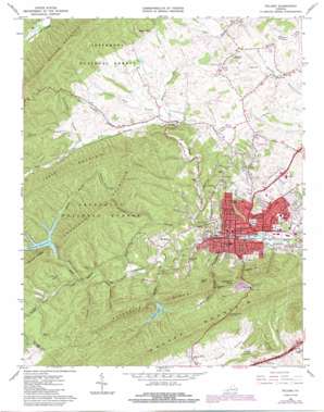
Pulaski Topo Map Virginia
To zoom in, hover over the map of Pulaski
USGS Topo Quad 37080a7 - 1:24,000 scale
| Topo Map Name: | Pulaski |
| USGS Topo Quad ID: | 37080a7 |
| Print Size: | ca. 21 1/4" wide x 27" high |
| Southeast Coordinates: | 37° N latitude / 80.75° W longitude |
| Map Center Coordinates: | 37.0625° N latitude / 80.8125° W longitude |
| U.S. State: | VA |
| Filename: | o37080a7.jpg |
| Download Map JPG Image: | Pulaski topo map 1:24,000 scale |
| Map Type: | Topographic |
| Topo Series: | 7.5´ |
| Map Scale: | 1:24,000 |
| Source of Map Images: | United States Geological Survey (USGS) |
| Alternate Map Versions: |
Pulaski VA 1965, updated 1967 Download PDF Buy paper map Pulaski VA 1965, updated 1971 Download PDF Buy paper map Pulaski VA 1965, updated 1978 Download PDF Buy paper map Pulaski VA 1965, updated 1984 Download PDF Buy paper map Pulaski VA 1976, updated 1983 Download PDF Buy paper map Pulaski VA 2011 Download PDF Buy paper map Pulaski VA 2013 Download PDF Buy paper map Pulaski VA 2016 Download PDF Buy paper map |
| FStopo: | US Forest Service topo Pulaski is available: Download FStopo PDF Download FStopo TIF |
1:24,000 Topo Quads surrounding Pulaski
> Back to 37080a1 at 1:100,000 scale
> Back to 37080a1 at 1:250,000 scale
> Back to U.S. Topo Maps home
Pulaski topo map: Gazetteer
Pulaski: Crossings
Interchange 92 elevation 657m 2155′Pulaski: Dams
Gatewood Dam elevation 642m 2106′Hogan Dam elevation 659m 2162′
Thornhill Dam elevation 642m 2106′
Pulaski: Parks
Calfee Park elevation 607m 1991′Jackson Park elevation 580m 1902′
Pulaski Historic Commercial District elevation 580m 1902′
Pulaski Historic Residential District elevation 608m 1994′
Pulaski Wayside Picnic Area elevation 836m 2742′
Pulaski: Populated Places
Altoona Mines (historical) elevation 706m 2316′Bella Vista elevation 678m 2224′
Clark (historical) elevation 680m 2230′
Gallimore elevation 634m 2080′
Hilton Village elevation 658m 2158′
Mount Olivet elevation 678m 2224′
Pulaski elevation 580m 1902′
Weldon elevation 622m 2040′
Pulaski: Post Offices
Pulaski Post Office elevation 579m 1899′Pulaski: Reservoirs
Gatewood Reservoir elevation 642m 2106′Hogan Lake elevation 659m 2162′
Thornhill Pond elevation 642m 2106′
Pulaski: Ridges
Caseknife Ridge elevation 752m 2467′Pulaski: Streams
Altoona Branch elevation 637m 2089′Bentley Branch elevation 622m 2040′
Big Shuffle Branch elevation 626m 2053′
East Fork Indian Grave Creek elevation 664m 2178′
Eddys Branch elevation 658m 2158′
Fortnerfield Branch elevation 631m 2070′
Harbison Branch elevation 601m 1971′
Hogan Branch elevation 603m 1978′
Indian Grave Creek elevation 632m 2073′
Kent Branch elevation 621m 2037′
Pondlick Branch elevation 596m 1955′
Rocky Branch elevation 608m 1994′
Tract Fork elevation 582m 1909′
Valley Branch elevation 590m 1935′
Pulaski: Summits
Chestnut Mountain elevation 850m 2788′Dusenberry Knob elevation 787m 2582′
Little Mountain elevation 775m 2542′
Tract Mountain elevation 826m 2709′
Pulaski: Valleys
Bateman Hollow elevation 695m 2280′Cricket Hollow elevation 627m 2057′
Dark Hollow elevation 632m 2073′
Tunnel Hollow elevation 632m 2073′
Pulaski digital topo map on disk
Buy this Pulaski topo map showing relief, roads, GPS coordinates and other geographical features, as a high-resolution digital map file on DVD:
Western Virginia & Southern West Virginia
Buy digital topo maps: Western Virginia & Southern West Virginia


