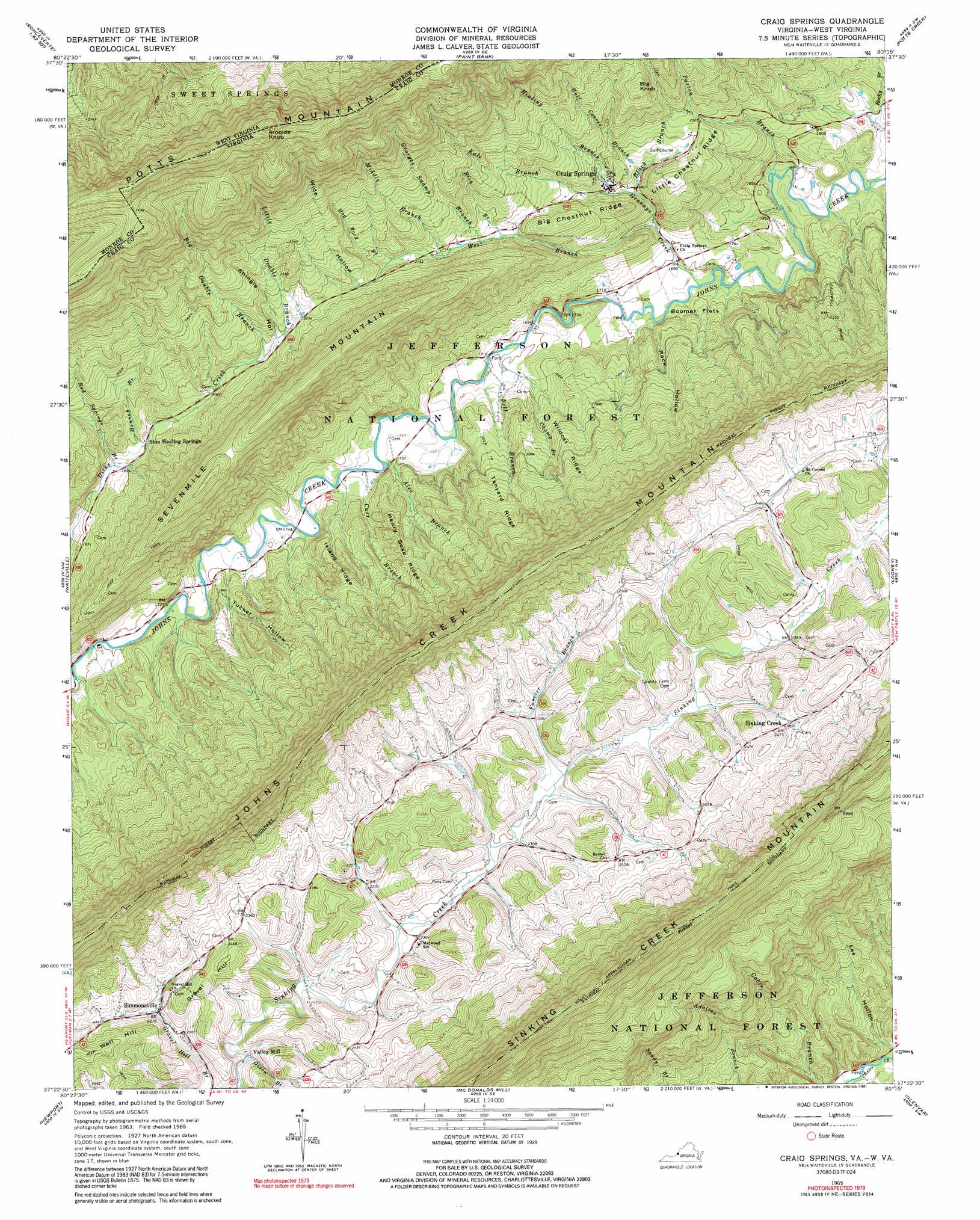
Craig Springs Topo Map Virginia
To zoom in, hover over the map of Craig Springs
USGS Topo Quad 37080d3 - 1:24,000 scale
| Topo Map Name: | Craig Springs |
| USGS Topo Quad ID: | 37080d3 |
| Print Size: | ca. 21 1/4" wide x 27" high |
| Southeast Coordinates: | 37.375° N latitude / 80.25° W longitude |
| Map Center Coordinates: | 37.4375° N latitude / 80.3125° W longitude |
| U.S. States: | VA, WV |
| Filename: | o37080d3.jpg |
| Download Map JPG Image: | Craig Springs topo map 1:24,000 scale |
| Map Type: | Topographic |
| Topo Series: | 7.5´ |
| Map Scale: | 1:24,000 |
| Source of Map Images: | United States Geological Survey (USGS) |
| Alternate Map Versions: |
Craig Springs VA 1965, updated 1967 Download PDF Buy paper map Craig Springs VA 1965, updated 1991 Download PDF Buy paper map Craig Springs VA 2011 Download PDF Buy paper map Craig Springs VA 2013 Download PDF Buy paper map Craig Springs VA 2016 Download PDF Buy paper map |
| FStopo: | US Forest Service topo Craig Springs is available: Download FStopo PDF Download FStopo TIF |
1:24,000 Topo Quads surrounding Craig Springs
Fort Spring |
Ronceverte |
Glace |
Alleghany |
Jordan Mines |
Union |
Gap Mills |
Paint Bank |
Potts Creek |
New Castle |
Interior |
Waiteville |
Craig Springs |
Looney |
Catawba |
Eggleston |
Newport |
Mcdonalds Mill |
Glenvar |
Salem |
Radford North |
Blacksburg |
Ironto |
Elliston |
Bent Mountain |
> Back to 37080a1 at 1:100,000 scale
> Back to 37080a1 at 1:250,000 scale
> Back to U.S. Topo Maps home
Craig Springs topo map: Gazetteer
Craig Springs: Flats
Boomer Flats elevation 523m 1715′Craig Springs: Populated Places
Craig Springs elevation 587m 1925′Simmonsville elevation 691m 2267′
Sinking Creek elevation 749m 2457′
Valley Mill elevation 676m 2217′
Craig Springs: Post Offices
Blue Healing Springs Post Office (historical) elevation 600m 1968′Craig Springs: Ridges
Big Chestnut Ridge elevation 657m 2155′Henry Soap Ridge elevation 639m 2096′
Island Ridge elevation 624m 2047′
Johns Creek Mountain elevation 926m 3038′
Little Chestnut Ridge elevation 648m 2125′
Tanyard Ridge elevation 657m 2155′
Wildcat Ridge elevation 658m 2158′
Craig Springs: Streams
Alec Branch elevation 528m 1732′Bell Branch elevation 514m 1686′
Black Branch elevation 569m 1866′
Carr Branch elevation 528m 1732′
Champ Branch elevation 518m 1699′
Dickey Farm Branch elevation 468m 1535′
Double Branch elevation 650m 2132′
Farrier Branch elevation 705m 2312′
Georges Swamp Branch elevation 628m 2060′
Given Branch elevation 676m 2217′
Golf Course Branch elevation 575m 1886′
Grannys Creek elevation 501m 1643′
Hannah Branch elevation 597m 1958′
Healing Branch elevation 575m 1886′
Hog Rock Branch elevation 655m 2148′
Kale Branch elevation 655m 2148′
Little Double Branch elevation 671m 2201′
Middle Branch elevation 636m 2086′
Paxton Branch elevation 493m 1617′
Red Springs Branch elevation 587m 1925′
Rich Branch elevation 619m 2030′
West Branch Grannys Creek elevation 530m 1738′
Craig Springs: Summits
Arnolds Knob elevation 1192m 3910′Arnolds Knob elevation 1186m 3891′
Big Knob elevation 750m 2460′
Gravel Hill elevation 757m 2483′
Moteshard Mountain elevation 1136m 3727′
Sevenmile Mountain elevation 846m 2775′
Well Hill elevation 770m 2526′
Craig Springs: Valleys
Rack Hollow elevation 516m 1692′Shingle Hollow elevation 667m 2188′
Tucker Hollow elevation 542m 1778′
Wide Hollow elevation 680m 2230′
Craig Springs digital topo map on disk
Buy this Craig Springs topo map showing relief, roads, GPS coordinates and other geographical features, as a high-resolution digital map file on DVD:
Western Virginia & Southern West Virginia
Buy digital topo maps: Western Virginia & Southern West Virginia